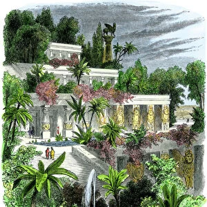
Metal Print > Historic > Ancient civilizations > Mesopotamia > Babylonian empire
Metal Print : Map showing the relation of the Median and second Babylonian (Chaldaean) Empires. From A Short History of the World, published c. 1936
 Empires. From A Short History of the World, published c. 1936")

![]()
Metal Prints From Design Pics
Map showing the relation of the Median and second Babylonian (Chaldaean) Empires. From A Short History of the World, published c. 1936
Map showing the relation of the Median and second Babylonian (Chaldaean) Empires. From A Short History of the World, published c.1936
Design Pics offers Distinctively Different Imagery representing over 1,500 contributors
Media ID 24907577
© Ken Welsh
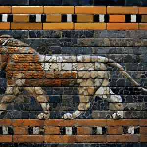
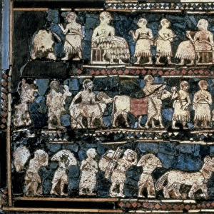
Cartography Countries Empire Geographical Geography Mapmaking Maps Mesopotamia Western Asia Babylonian Chaldaean Chaldean Empires Median Relation Southwest Asia West Asia
16"x20" (51x41cm) Metal Print
Step back in time with our captivating Metal Print of the Median and Second Babylonian (Chaldaean) Empires Map. This intricately detailed historical map, taken from "A Short History of the World" published c.1936 by Ken Welsh, showcases the geographical relationship between these ancient civilizations. The Metal Print's vivid colors and high-quality finish bring the history to life, making it a stunning addition to any home or office. With its durable and water-resistant properties, this Metal Print is not only a beautiful piece of art but also a long-lasting investment. Transport yourself back to the ancient world and explore the rich history of the Medes and Chaldeans with this captivating and informative display.
Made with durable metal and luxurious printing techniques, our metal photo prints go beyond traditional canvases, adding a cool, modern touch to your space. Wall mount on back. Eco-friendly 100% post-consumer recycled ChromaLuxe aluminum surface. The thickness of the print is 0.045". Featuring a Scratch-resistant surface and Rounded corners. Backing hangers are attached to the back of the print and float the print 1/2-inch off the wall when hung, the choice of hanger may vary depending on size and International orders will come with Float Mount hangers only. Finished with a brilliant white high gloss surface for unsurpassed detail and vibrance. Printed using Dye-Sublimation and for best care we recommend a non-ammonia glass cleaner, water, or isopropyl (rubbing) alcohol to prevent harming the print surface. We recommend using a clean, lint-free cloth to wipe off the print. The ultra-hard surface is scratch-resistant, waterproof and weatherproof. Avoid direct sunlight exposure.
Made with durable metal and luxurious printing techniques, metal prints bring images to life and add a modern touch to any space
Estimated Image Size (if not cropped) is 50.8cm x 40.6cm (20" x 16")
Estimated Product Size is 51.4cm x 41.2cm (20.2" x 16.2")
These are individually made so all sizes are approximate
Artwork printed orientated as per the preview above, with landscape (horizontal) orientation to match the source image.
FEATURES IN THESE COLLECTIONS
> Arts
> Artists
> B
> Babylonian Babylonian
> Historic
> Ancient civilizations
> Babylonian Empire
> Historic
> Ancient civilizations
> Mesopotamia
> Babylonian empire
> Maps and Charts
> Early Maps
> Maps and Charts
> World
EDITORS COMMENTS
This print showcases a historical map from A Short History of the World, published around 1936. The map depicts the intricate relationship between two powerful empires - the Median and second Babylonian (Chaldaean) Empires. Mesopotamia, located in Western Asia or what is now known as Southwest Asia, served as the backdrop for these ancient civilizations. Through careful cartography and engraving techniques, this vintage illustration provides a glimpse into the geographical boundaries and territories of these influential empires. The archival quality of this picture allows us to delve into history and explore how these empires shaped their respective countries during that period. It serves as a valuable resource for historians and researchers interested in understanding the political dynamics of ancient Mesopotamia. Ken Welsh's expertise in capturing historical moments through his lens is evident in this remarkable print. His attention to detail brings out the significance of maps as tools for visualizing past events and understanding complex relationships between nations. Whether you are an enthusiast of cartography or simply intrigued by history, this print offers an engaging window into a bygone era – one where empires rose and fell, leaving behind legacies that continue to shape our world today.
MADE IN THE USA
Safe Shipping with 30 Day Money Back Guarantee
FREE PERSONALISATION*
We are proud to offer a range of customisation features including Personalised Captions, Color Filters and Picture Zoom Tools
SECURE PAYMENTS
We happily accept a wide range of payment options so you can pay for the things you need in the way that is most convenient for you
* Options may vary by product and licensing agreement. Zoomed Pictures can be adjusted in the Basket.