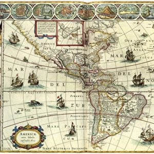
Metal Print > Maps and Charts > Early Maps
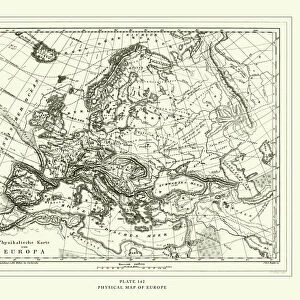
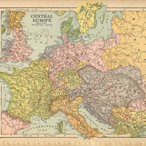
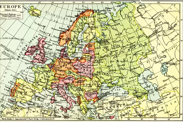
Metal Print : A 1930s Map Of Europe


![]()
Metal Prints from Design Pics
A 1930s Map Of Europe
Design Pics offers Distinctively Different Imagery representing over 1,500 contributors
Media ID 18176902
© Hilary Jane Morgan / Design Pics
1930s 20th Countries Geographical Geography Nineteen Thirties Twentieth
16"x24" (61x41cm) Metal Print
Step back in time with our stunning Media Storehouse Metal Print featuring a captivating 1930s Map of Europe by Hilary Jane Morgan from Design Pics. This vintage map transports you to an era of history filled with intrigue and adventure. The high-quality metal print not only showcases the intricate details of the map but also adds a contemporary twist with its sleek and modern design. With vibrant colors and sharp lines, this unique piece is sure to be a conversation starter in any room. Order now and bring a piece of history into your home or office.
Made with durable metal and luxurious printing techniques, our metal photo prints go beyond traditional canvases, adding a cool, modern touch to your space. Wall mount on back. Eco-friendly 100% post-consumer recycled ChromaLuxe aluminum surface. The thickness of the print is 0.045". Featuring a Scratch-resistant surface and Rounded corners. Backing hangers are attached to the back of the print and float the print 1/2-inch off the wall when hung, the choice of hanger may vary depending on size and International orders will come with Float Mount hangers only. Finished with a brilliant white high gloss surface for unsurpassed detail and vibrance. Printed using Dye-Sublimation and for best care we recommend a non-ammonia glass cleaner, water, or isopropyl (rubbing) alcohol to prevent harming the print surface. We recommend using a clean, lint-free cloth to wipe off the print. The ultra-hard surface is scratch-resistant, waterproof and weatherproof. Avoid direct sunlight exposure.
Made with durable metal and luxurious printing techniques, metal prints bring images to life and add a modern touch to any space
Estimated Product Size is 61.5cm x 41.2cm (24.2" x 16.2")
These are individually made so all sizes are approximate
Artwork printed orientated as per the preview above, with landscape (horizontal) orientation to match the source image.
FEATURES IN THESE COLLECTIONS
> Design Pics
> Design Pics Art
> Art llustrations and Engravings
> Maps and Charts
> Early Maps
> Maps and Charts
> Related Images
EDITORS COMMENTS
This print showcases a remarkable piece of history - a 1930s map of Europe meticulously crafted by the talented Hilary Jane Morgan. With its intricate details and vintage charm, this illustration takes us back to the early 20th century, offering a glimpse into European geography during that era. As we gaze upon this historical gem, our eyes are immediately drawn to the various countries that make up the continent. Each border is delicately outlined, highlighting the diverse nations that existed at that time. From bustling cities to serene countryside landscapes, this map captures Europe's rich tapestry of cultures and traditions. The artist's attention to detail is truly commendable; every river, mountain range, and coastline has been intricately depicted with precision. This stunning visual representation not only serves as an educational tool but also evokes nostalgia for a bygone era when borders were different and geopolitical dynamics were rapidly evolving. Whether you're an avid historian or simply appreciate artistry in its purest form, this 1930s Map of Europe will undoubtedly captivate your imagination. Hang it on your wall or display it proudly in your study – let it transport you back in time while igniting curiosity about how our world has transformed over the decades. Hilary Jane Morgan's masterpiece reminds us of the power maps hold in telling stories about our past and shaping our understanding of the present.
MADE IN THE USA
Safe Shipping with 30 Day Money Back Guarantee
FREE PERSONALISATION*
We are proud to offer a range of customisation features including Personalised Captions, Color Filters and Picture Zoom Tools
SECURE PAYMENTS
We happily accept a wide range of payment options so you can pay for the things you need in the way that is most convenient for you
* Options may vary by product and licensing agreement. Zoomed Pictures can be adjusted in the Cart.