Metal Print > Aerial Photography > Austria
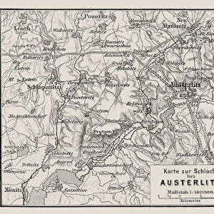
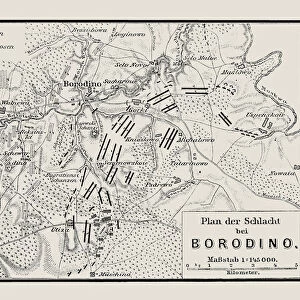
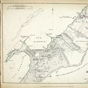
Metal Print : Map of the Battle of Austerlitz, published by William Blackwood and Sons


![]()
Metal Prints from Fine Art Finder
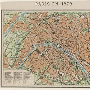
Map of the Battle of Austerlitz, published by William Blackwood and Sons
746911 Map of the Battle of Austerlitz, published by William Blackwood and Sons, Edinburgh & London, 1848 (hand-coloured engraving) by Johnston, Alexander Keith (1804-71); Private Collection; (add.info.: Battle of Austerlitz (2 December 1805)); The Stapleton Collection; Scottish, out of copyright
Media ID 23168512
© The Stapleton Collection / Bridgeman Images
Aerial View Armies Mapping Napoleon Positions
16"x20" (51x41cm) Metal Print
Experience the historical depth of the Battle of Austerlitz with our stunning Metal Prints from Media Storehouse. This exquisite piece features a captivating map, published by William Blackwood and Sons in 1848. Meticulously hand-coloured and originally engraved by Johnston, this detailed representation of the Battle of Austerlitz, a significant victory for Napoleon Bonaparte, is a must-have for history enthusiasts and art collectors alike. Our high-quality Metal Prints bring out the rich colors and intricate details of this Bridgeman Images masterpiece, ensuring a stunning addition to any room in your home or office. Order now and relive the grandeur of the past with this beautiful work of art.
Made with durable metal and luxurious printing techniques, our metal photo prints go beyond traditional canvases, adding a cool, modern touch to your space. Wall mount on back. Eco-friendly 100% post-consumer recycled ChromaLuxe aluminum surface. The thickness of the print is 0.045". Featuring a Scratch-resistant surface and Rounded corners. Backing hangers are attached to the back of the print and float the print 1/2-inch off the wall when hung, the choice of hanger may vary depending on size and International orders will come with Float Mount hangers only. Finished with a brilliant white high gloss surface for unsurpassed detail and vibrance. Printed using Dye-Sublimation and for best care we recommend a non-ammonia glass cleaner, water, or isopropyl (rubbing) alcohol to prevent harming the print surface. We recommend using a clean, lint-free cloth to wipe off the print. The ultra-hard surface is scratch-resistant, waterproof and weatherproof. Avoid direct sunlight exposure.
Made with durable metal and luxurious printing techniques, metal prints bring images to life and add a modern touch to any space
Estimated Image Size (if not cropped) is 50.8cm x 40.6cm (20" x 16")
Estimated Product Size is 51.4cm x 41.2cm (20.2" x 16.2")
These are individually made so all sizes are approximate
Artwork printed orientated as per the preview above, with landscape (horizontal) orientation to match the source image.
FEATURES IN THESE COLLECTIONS
> Fine Art Finder
> Artists
> Alexander Keith Johnston
> Fine Art Finder
> Maps (celestial & Terrestrial)
> Aerial Photography
> Austria
> Aerial Photography
> Related Images
> Aerial Photography
> Scotland
> Arts
> Artists
> A
> William Alexander
> Arts
> Artists
> K
> William Keith
> Europe
> Austria
> Aerial Views
EDITORS COMMENTS
This print showcases a remarkable piece of history, the "Map of the Battle of Austerlitz". Published in 1848 by William Blackwood and Sons, this hand-coloured engraving by Alexander Keith Johnston provides an aerial view of one of Napoleon's most significant victories. The Battle of Austerlitz took place on 2 December 1805 and is also known as the Battle of the Three Emperors. The intricately detailed map allows us to delve into the strategic positions and movements of both French and Austrian armies during this historic clash. It offers a glimpse into the c19th era when cartography was essential for military planning. The presence of Russian forces is also depicted, highlighting their involvement in this monumental battle. As we observe this meticulously crafted engraving from Bridgeman Images' Private Collection, we are transported back in time to witness Napoleon's tactical brilliance unfold before our eyes. The vibrant hand-colouring adds depth and life to every line drawn on this historical document. This extraordinary print not only serves as a testament to Johnston's skillful artistry but also reminds us that even centuries later, battles like these continue to captivate our imagination. It stands as a tribute to those who fought bravely on both sides while offering invaluable insights into an important chapter in European history.
MADE IN THE USA
Safe Shipping with 30 Day Money Back Guarantee
FREE PERSONALISATION*
We are proud to offer a range of customisation features including Personalised Captions, Color Filters and Picture Zoom Tools
SECURE PAYMENTS
We happily accept a wide range of payment options so you can pay for the things you need in the way that is most convenient for you
* Options may vary by product and licensing agreement. Zoomed Pictures can be adjusted in the Cart.