Metal Print > North America > United States of America > Maps
Metal Print : General map of the camps and marche of the army in America on the orders of Rochambeau


![]()
Metal Prints from Fine Art Finder
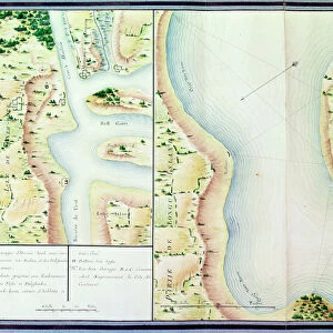
General map of the camps and marche of the army in America on the orders of Rochambeau
XIR440788 General map of the camps and marche of the army in America on the orders of Rochambeau, detail of the left side, from Guerre de l Amerique, c.1780-81 (colour engraving) (see also 440787) by Dubourg, F. (fl.1780-82); Service Historique de la Marine, Vincennes, France; (add.info.: Jean-Baptiste de Vimeur (1725-1807) Count of Rochambeau; ); French, out of copyright
Media ID 18256163
© Service Historique de la Marine, Vincennes, France / Bridgeman Images
American War Of Independence Camps Chesapeake Bay Encampment Encampments Journeys Maryland Orders Revolutionary War Rochambeau
16"x24" (61x41cm) Metal Print
Bring history to life with our stunning Metal Prints from Media Storehouse, featuring the intricately detailed map of the American army's camps and marches, ordered by General Rochambeau. This captivating image from Bridgeman Images, XIR440788, titled "Guerre de l'Amerique: General map of the camps and marche of the army in America on the orders of Rochambeau (detail of the left side)," is a must-have for history enthusiasts and art collectors. Our Metal Prints are known for their vibrant colors, rich textures, and long-lasting durability, making them a beautiful addition to any home or office space. Transport yourself back in time with this exquisite piece of fine art from Fine Art Finder.
Made with durable metal and luxurious printing techniques, our metal photo prints go beyond traditional canvases, adding a cool, modern touch to your space. Wall mount on back. Eco-friendly 100% post-consumer recycled ChromaLuxe aluminum surface. The thickness of the print is 0.045". Featuring a Scratch-resistant surface and Rounded corners. Backing hangers are attached to the back of the print and float the print 1/2-inch off the wall when hung, the choice of hanger may vary depending on size and International orders will come with Float Mount hangers only. Finished with a brilliant white high gloss surface for unsurpassed detail and vibrance. Printed using Dye-Sublimation and for best care we recommend a non-ammonia glass cleaner, water, or isopropyl (rubbing) alcohol to prevent harming the print surface. We recommend using a clean, lint-free cloth to wipe off the print. The ultra-hard surface is scratch-resistant, waterproof and weatherproof. Avoid direct sunlight exposure.
Made with durable metal and luxurious printing techniques, metal prints bring images to life and add a modern touch to any space
Estimated Product Size is 61.5cm x 41.2cm (24.2" x 16.2")
These are individually made so all sizes are approximate
Artwork printed orientated as per the preview above, with landscape (horizontal) orientation to match the source image.
FEATURES IN THESE COLLECTIONS
> Fine Art Finder
> Artists
> F. Dubourg
> Maps and Charts
> Related Images
> North America
> United States of America
> Delaware
> Related Images
> North America
> United States of America
> Maps
> North America
> United States of America
> Maryland
> Related Images
EDITORS COMMENTS
This print showcases a detailed map titled "General Map of the Camps and Marche of the Army in America on the Orders of Rochambeau". Created by French cartographer F. Dubourg around 1780-81, this color engraving provides an invaluable glimpse into the American War of Independence. The left side detail highlights various aspects of this historical journey. It vividly depicts the coastal regions, including Delaware Bay and Chesapeake Bay, where crucial military movements took place during this period. The encampments and campsites are meticulously marked, offering insight into the strategic positioning of troops under General Jean-Baptiste de Vimeur, Count of Rochambeau. As one delves deeper into this remarkable artwork, it becomes evident that every element has been thoughtfully portrayed to convey both geographical accuracy and historical significance. The map serves as a testament to Rochambeau's leadership and his pivotal role in supporting American forces against British rule. Preserved at Service Historique de la Marine in Vincennes, France, this piece represents an essential resource for scholars studying the Revolutionary War era. Its rich details not only provide valuable insights into troop movements but also evoke a sense of awe for those who appreciate cartography as an art form. Through its intricate depiction of coastlines, encampments, and orders given by Rochambeau himself, this extraordinary map offers viewers a window into history—an opportunity to witness firsthand how these brave soldiers navigated through challenging terrain to fight
MADE IN THE USA
Safe Shipping with 30 Day Money Back Guarantee
FREE PERSONALISATION*
We are proud to offer a range of customisation features including Personalised Captions, Color Filters and Picture Zoom Tools
SECURE PAYMENTS
We happily accept a wide range of payment options so you can pay for the things you need in the way that is most convenient for you
* Options may vary by product and licensing agreement. Zoomed Pictures can be adjusted in the Cart.