Metal Print > Europe > Montenegro > Maps
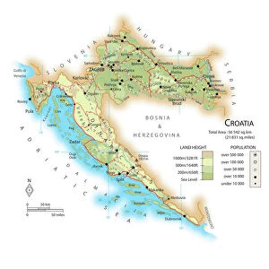
Metal Print : Map of the Kingdom of Dalmatia (present-day Croatia and Montenegro)
")


![]()
Metal Prints from Fine Art Finder
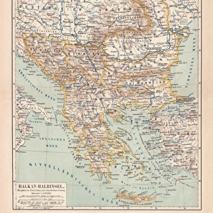
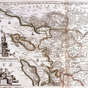
Map of the Kingdom of Dalmatia (present-day Croatia and Montenegro)
LRI4711368 Map of the Kingdom of Dalmatia (present-day Croatia and Montenegro), on the coast of the Gulf of Venice (Adriatic Sea) (Engraving, 1717) by Nolin, Jean-Baptiste (c.1657-1708); Private Collection; (add.info.: Map of the Kingdom of Dalmatia (present-day Croatia and Montenegro), on the coast of the Gulf of Venice (Adriatic Sea) - Engraving from the atlas le theatre du monde, 1717, by Jean Baptiste Nolin (1686-1762) - Map of the Kingdom of Dalmatia - From " Le Theatre du Monde" 1717 by Jean-Baptiste Nolin); Luisa Ricciarini; French, out of copyright
Media ID 22278606
© Luisa Ricciarini / Bridgeman Images
Atlas Book Balkans Croatia Montenegro Geographical Map
16"x20" (51x41cm) Metal Print
Discover the rich history of Dalmatia with our stunning Metal Print of the Map of the Kingdom of Dalmatia, featuring the intricate detail of Luisa Ricciarini's 1717 engraving from Fine Art Finder. This beautiful piece showcases the coastline of present-day Croatia and Montenegro along the Adriatic Sea. Our Metal Prints are known for their vibrant colors, crisp details, and long-lasting durability. Bring history into your home or office with this unique and captivating addition to your decor.
Made with durable metal and luxurious printing techniques, our metal photo prints go beyond traditional canvases, adding a cool, modern touch to your space. Wall mount on back. Eco-friendly 100% post-consumer recycled ChromaLuxe aluminum surface. The thickness of the print is 0.045". Featuring a Scratch-resistant surface and Rounded corners. Backing hangers are attached to the back of the print and float the print 1/2-inch off the wall when hung, the choice of hanger may vary depending on size and International orders will come with Float Mount hangers only. Finished with a brilliant white high gloss surface for unsurpassed detail and vibrance. Printed using Dye-Sublimation and for best care we recommend a non-ammonia glass cleaner, water, or isopropyl (rubbing) alcohol to prevent harming the print surface. We recommend using a clean, lint-free cloth to wipe off the print. The ultra-hard surface is scratch-resistant, waterproof and weatherproof. Avoid direct sunlight exposure.
Made with durable metal and luxurious printing techniques, metal prints bring images to life and add a modern touch to any space
Estimated Image Size (if not cropped) is 50.8cm x 40.6cm (20" x 16")
Estimated Product Size is 51.4cm x 41.2cm (20.2" x 16.2")
These are individually made so all sizes are approximate
Artwork printed orientated as per the preview above, with landscape (horizontal) orientation to match the source image.
FEATURES IN THESE COLLECTIONS
> Fine Art Finder
> Artists
> Jean-Baptiste Nolin
> Europe
> Croatia
> Related Images
> Europe
> Montenegro
> Maps
> Europe
> Montenegro
> Posters
> Europe
> Montenegro
> Related Images
> Maps and Charts
> Montenegro
EDITORS COMMENTS
This engraving, titled "Map of the Kingdom of Dalmatia" takes us back to the year 1717 and offers a glimpse into the historical geography of present-day Croatia and Montenegro. Created by Jean-Baptiste Nolin, a renowned French cartographer, this intricate map showcases the coastal region along the Gulf of Venice (Adriatic Sea). The level of detail in this print is truly remarkable. Every contour line, river, and city is meticulously engraved onto the paper, providing an accurate representation of this significant area in Europe. As we explore this map further, we can see how it captures not only geographical features but also political boundaries. Dalmatia's strategic location on the Balkan Peninsula has made it a coveted territory throughout history. This map allows us to appreciate its importance as it highlights key cities such as Split and Dubrovnik (Ragusa). It serves as a testament to centuries-old trade routes that connected these coastal towns with neighboring regions. Preserved within private collections today, this engraving from Nolin's atlas book "Le Theatre du Monde" transports us back in time. Its ageless charm reminds us of the enduring significance of cartography in understanding our world's past. Luisa Ricciarini expertly captures every detail through her lens while photographing this historical artifact for Fine Art Finder. Her skillful composition ensures that viewers can appreciate both the artistic beauty and educational value held within this remarkable piece from centuries ago.
MADE IN THE USA
Safe Shipping with 30 Day Money Back Guarantee
FREE PERSONALISATION*
We are proud to offer a range of customisation features including Personalised Captions, Color Filters and Picture Zoom Tools
SECURE PAYMENTS
We happily accept a wide range of payment options so you can pay for the things you need in the way that is most convenient for you
* Options may vary by product and licensing agreement. Zoomed Pictures can be adjusted in the Cart.