Metal Print > Europe > United Kingdom > England > London > Towns > Camberwell
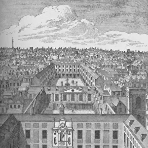
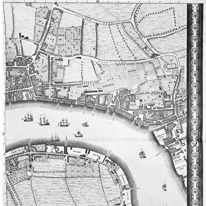
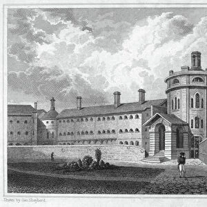
Metal Print : A Map of Bermondsey, London, 1746 (engraving)
")


![]()
Metal Prints from Fine Art Finder
A Map of Bermondsey, London, 1746 (engraving)
XJF438442 A Map of Bermondsey, London, 1746 (engraving) by Rocque, John (c.1704-d.1762); Private Collection; British, out of copyright
Media ID 12881125
© www.bridgemanimages.com
Aerial View Area Bermondsey Camberwell Farm Land Farmland Fields Outskirts Suburb The Grange Turnpike Neckinger
16"x20" (51x41cm) Metal Print
Discover the rich history of Bermondsey, London with our stunning Metal Prints from Media Storehouse. Featuring an intricately detailed engraving of "A Map of Bermondsey, London, 1746" by John Rocque, these prints bring the past to life with their vibrant colors and high-quality metallic finish. This beautifully preserved image, sourced from Bridgeman Images through Fine Art Finder, offers a unique and captivating glimpse into the history of this fascinating area. Elevate your home or office décor with this timeless piece of art, available as a Metal Print from Media Storehouse.
Made with durable metal and luxurious printing techniques, our metal photo prints go beyond traditional canvases, adding a cool, modern touch to your space. Wall mount on back. Eco-friendly 100% post-consumer recycled ChromaLuxe aluminum surface. The thickness of the print is 0.045". Featuring a Scratch-resistant surface and Rounded corners. Backing hangers are attached to the back of the print and float the print 1/2-inch off the wall when hung, the choice of hanger may vary depending on size and International orders will come with Float Mount hangers only. Finished with a brilliant white high gloss surface for unsurpassed detail and vibrance. Printed using Dye-Sublimation and for best care we recommend a non-ammonia glass cleaner, water, or isopropyl (rubbing) alcohol to prevent harming the print surface. We recommend using a clean, lint-free cloth to wipe off the print. The ultra-hard surface is scratch-resistant, waterproof and weatherproof. Avoid direct sunlight exposure.
Made with durable metal and luxurious printing techniques, metal prints bring images to life and add a modern touch to any space
Estimated Image Size (if not cropped) is 40.6cm x 50.8cm (16" x 20")
Estimated Product Size is 41.2cm x 51.4cm (16.2" x 20.2")
These are individually made so all sizes are approximate
Artwork printed orientated as per the preview above, with portrait (vertical) orientation to match the source image.
FEATURES IN THESE COLLECTIONS
> Fine Art Finder
> Artists
> John Rocque
> Aerial Photography
> Related Images
> Arts
> Artists
> F
> John Field
> Arts
> Artists
> R
> John Rocque
> Europe
> France
> Canton
> Landes
> Europe
> United Kingdom
> England
> Kent
> Grange
> Europe
> United Kingdom
> England
> London
> Towns
> Bermondsey
> Europe
> United Kingdom
> England
> London
> Towns
> Camberwell
> Maps and Charts
> Related Images
EDITORS COMMENTS
This print takes us back in time to the year 1746, offering a glimpse into the historical landscape of Bermondsey, London. The intricate engraving by John Rocque showcases the city's evolution during this era, capturing its essence with remarkable detail. As we delve into this visual treasure trove, our eyes wander across the map's expansive canvas. From the bustling heart of the city to its tranquil outskirts and sprawling fields, every inch tells a story of urban growth and rural charm. The old Kent Road winds its way through neighborhoods like Blue Anchor and New Neckinger, revealing their importance as vital arteries connecting different parts of Bermondsey. Our gaze is drawn towards significant landmarks such as Tanners Yard and Turnpike, reminding us of their pivotal roles in shaping daily life for residents at that time. The Grange stands proudly amidst lush surroundings while Hop Walk exudes an air of agricultural prosperity with its flourishing farmland. Beyond Bermondsey's borders lies Cherry Garden and Camberwell, extending our understanding beyond one area to encompass neighboring regions. This aerial view provides a unique perspective on SE1's layout and highlights how interconnected these districts were even centuries ago. Intriguingly rich in history and meticulously crafted by Rocque's skilled hand, this engraving transports us back to an era when London was still taking shape. It serves as a testament to both artistic prowess and cartographic precision—a true masterpiece preserved within private collections for all admirers to appreciate today.
MADE IN THE USA
Safe Shipping with 30 Day Money Back Guarantee
FREE PERSONALISATION*
We are proud to offer a range of customisation features including Personalised Captions, Color Filters and Picture Zoom Tools
SECURE PAYMENTS
We happily accept a wide range of payment options so you can pay for the things you need in the way that is most convenient for you
* Options may vary by product and licensing agreement. Zoomed Pictures can be adjusted in the Cart.