Metal Print > Europe > Netherlands > Maps
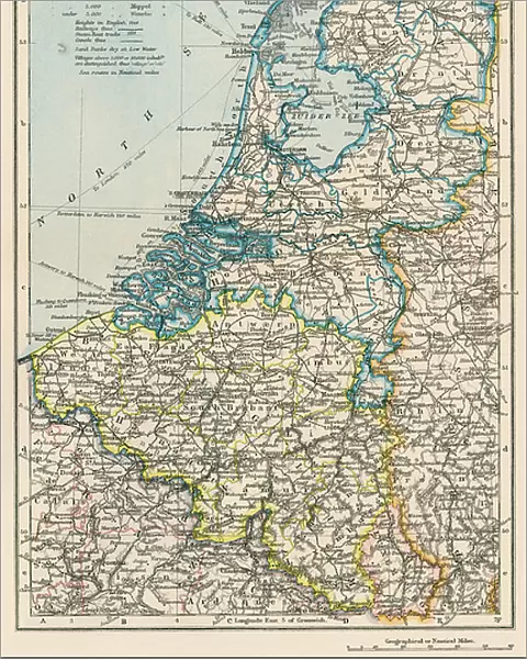
Metal Print : Map of the Netherlands and Belgium, around 1870 - Lithograph 19th century - Map of the Netherlands and Belgium, 1870s - Color lithograph


![]()
Metal Prints from Fine Art Finder
Map of the Netherlands and Belgium, around 1870 - Lithograph 19th century - Map of the Netherlands and Belgium, 1870s - Color lithograph
NWI4872346 Map of the Netherlands and Belgium, around 1870 - Lithograph 19th century - Map of the Netherlands and Belgium, 1870s - Color lithograph; (add.info.: Map of the Netherlands and Belgium, around 1870 - Lithograph 19th century - Map of the Netherlands and Belgium, 1870s - Color lithograph); Photo © North Wind Pictures
Media ID 38335620
© © North Wind Pictures / Bridgeman Images
Belgians Belgium Belgian Dutch Netherlands Geographical Map Hollander Hollanders Netherland Netherlands Holland Dutch The Netherland
16"x20" (51x41cm) Metal Print
Explore the rich history of Europe with our stunning Metal Prints from Bridgeman Images! This vintage map, dating back to around 1870, showcases a beautifully rendered color lithograph of the Netherlands and Belgium during that era. A unique piece for any history enthusiast or art lover, this metal print is sure to add a touch of elegance and sophistication to any room.
Made with durable metal and luxurious printing techniques, our metal photo prints go beyond traditional canvases, adding a cool, modern touch to your space. Wall mount on back. Eco-friendly 100% post-consumer recycled ChromaLuxe aluminum surface. The thickness of the print is 0.045". Featuring a Scratch-resistant surface and Rounded corners. Backing hangers are attached to the back of the print and float the print 1/2-inch off the wall when hung, the choice of hanger may vary depending on size and International orders will come with Float Mount hangers only. Finished with a brilliant white high gloss surface for unsurpassed detail and vibrance. Printed using Dye-Sublimation and for best care we recommend a non-ammonia glass cleaner, water, or isopropyl (rubbing) alcohol to prevent harming the print surface. We recommend using a clean, lint-free cloth to wipe off the print. The ultra-hard surface is scratch-resistant, waterproof and weatherproof. Avoid direct sunlight exposure.
Made with durable metal and luxurious printing techniques, metal prints bring images to life and add a modern touch to any space
Estimated Image Size (if not cropped) is 40.6cm x 50.8cm (16" x 20")
Estimated Product Size is 41.2cm x 51.4cm (16.2" x 20.2")
These are individually made so all sizes are approximate
Artwork printed orientated as per the preview above, with portrait (vertical) orientation to match the source image.
FEATURES IN THESE COLLECTIONS
> Fine Art Finder
> Artists
> Spanish School (after)
> Europe
> Belgium
> Related Images
> Europe
> Netherlands
> Maps
> Europe
> Netherlands
> Posters
> Europe
> Netherlands
> Related Images
> Maps and Charts
> Early Maps
> Maps and Charts
> Netherlands
EDITORS COMMENTS
This stunning lithograph from the 19th century showcases a detailed map of the Netherlands and Belgium, dating back to around 1870. The intricate lines and vibrant colors bring this historical piece to life, offering a glimpse into the geographical landscape of these European countries during that time period.
The map is filled with fascinating details, from the names of cities and towns to rivers and borders. It serves as a valuable historical document, providing insight into the political and cultural boundaries of the region in the late 19th century.
The color lithograph technique used to create this map adds an artistic flair to what could have been a simple cartographic representation. The hues chosen for each area help differentiate between regions and make it easier for viewers to distinguish between different parts of the map.
Whether you are a history buff, geography enthusiast, or simply appreciate fine art, this Map of the Netherlands and Belgium print is sure to captivate your attention. Display it proudly in your home or office as a conversation starter and reminder of days gone by in these beautiful European countries.
MADE IN THE USA
Safe Shipping with 30 Day Money Back Guarantee
FREE PERSONALISATION*
We are proud to offer a range of customisation features including Personalised Captions, Color Filters and Picture Zoom Tools
SECURE PAYMENTS
We happily accept a wide range of payment options so you can pay for the things you need in the way that is most convenient for you
* Options may vary by product and licensing agreement. Zoomed Pictures can be adjusted in the Cart.