Metal Print > Arts > Artists > S > Syrian Syrian
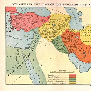
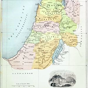
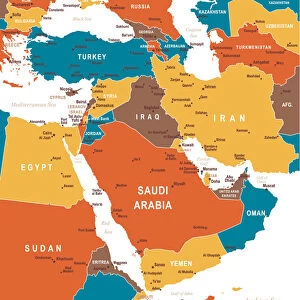
Metal Print : Map of the Middle East: Turkish Empire, Persia and Arabian Peninsula (etching, 1730)
")


![]()
Metal Prints from Fine Art Finder
Map of the Middle East: Turkish Empire, Persia and Arabian Peninsula (etching, 1730)
LRI4706712 Map of the Middle East: Turkish Empire, Persia and Arabian Peninsula (etching, 1730) by Delisle, Guillaume (1675-1726); Private Collection; (add.info.: Map of the Middle East: Turkish Empire, Persia and Arabian Peninsula - Strong water extracted from the " New Atlas containing all parts of the world" 1730 by Guillaume de L Isle (1675-1726)); Luisa Ricciarini; French, out of copyright
Media ID 22278662
© Luisa Ricciarini / Bridgeman Images
Atlas Book Iran Iranian Iraq Iraqi Israel Israeli Jordan Lebanese Lebanon Libya Libyan Saudi Arabia Syria Yemen Geographical Map Grece Turk
16"x20" (51x41cm) Metal Print
Discover the rich history of the Middle East with our stunning Metal Print of the Map of the Middle East: Turkish Empire, Persia and Arabian Peninsula, an exquisite etching from 1730 by Guillaume Delisle. This intricately detailed map, showcasing the Turkish Empire, Persia, and the Arabian Peninsula, is a beautiful addition to any home or office. Meticulously reproduced from the original etching held in a private collection, our Metal Print brings the history and artistry of the past to life in a modern and vibrant way. The high-quality metal print is not only a decorative piece but also a conversation starter, making it a thoughtful gift for history enthusiasts and world travelers alike.
Made with durable metal and luxurious printing techniques, our metal photo prints go beyond traditional canvases, adding a cool, modern touch to your space. Wall mount on back. Eco-friendly 100% post-consumer recycled ChromaLuxe aluminum surface. The thickness of the print is 0.045". Featuring a Scratch-resistant surface and Rounded corners. Backing hangers are attached to the back of the print and float the print 1/2-inch off the wall when hung, the choice of hanger may vary depending on size and International orders will come with Float Mount hangers only. Finished with a brilliant white high gloss surface for unsurpassed detail and vibrance. Printed using Dye-Sublimation and for best care we recommend a non-ammonia glass cleaner, water, or isopropyl (rubbing) alcohol to prevent harming the print surface. We recommend using a clean, lint-free cloth to wipe off the print. The ultra-hard surface is scratch-resistant, waterproof and weatherproof. Avoid direct sunlight exposure.
Made with durable metal and luxurious printing techniques, metal prints bring images to life and add a modern touch to any space
Estimated Image Size (if not cropped) is 50.8cm x 40.6cm (20" x 16")
Estimated Product Size is 51.4cm x 41.2cm (20.2" x 16.2")
These are individually made so all sizes are approximate
Artwork printed orientated as per the preview above, with landscape (horizontal) orientation to match the source image.
FEATURES IN THESE COLLECTIONS
> Fine Art Finder
> Artists
> Guillaume Delisle
> Fine Art Finder
> Artists
> Unknown Artist
> Africa
> Libya
> Related Images
> Arts
> Artists
> S
> Syrian Syrian
> Asia
> Iran
> Related Images
> Asia
> Iraq
> Related Images
> Asia
> Israel
> Related Images
EDITORS COMMENTS
This etching from 1730, titled "Map of the Middle East: Turkish Empire, Persia and Arabian Peninsula" takes us on a visual journey through the intricate geography of the region. Created by Guillaume de L'Isle, a renowned French cartographer, this map offers a glimpse into the political landscape of the time. The delicate lines and intricate details showcase De L'Isle's mastery in capturing geographical accuracy. The map encompasses vast territories including present-day Turkey, Iran, Iraq, Syria, Israel, Saudi Arabia, Lebanon, Jordan, Yemen and parts of Greece and Libya. It provides an invaluable historical record of these regions during the 18th century. As we explore this ancient world through De L'Isle's eyes, we are transported to a time when empires ruled over diverse cultures and landscapes. The Turkish Empire dominates much of the map with its sprawling borders stretching across Anatolia and beyond. We can also trace the Persian influence in what is now modern-day Iran. Beyond political boundaries lie rich topographical features such as rivers snaking their way through arid deserts or lush valleys nestled between towering mountains. This meticulous attention to detail invites us to appreciate not only the political significance but also the natural beauty that defines this part of our world. Luisa Ricciarini has skillfully preserved this historical treasure for future generations to admire. As we gaze upon this remarkable print today, it serves as a reminder that maps are not just tools for navigation but
MADE IN THE USA
Safe Shipping with 30 Day Money Back Guarantee
FREE PERSONALISATION*
We are proud to offer a range of customisation features including Personalised Captions, Color Filters and Picture Zoom Tools
SECURE PAYMENTS
We happily accept a wide range of payment options so you can pay for the things you need in the way that is most convenient for you
* Options may vary by product and licensing agreement. Zoomed Pictures can be adjusted in the Cart.


![[Plaza of Canons, Teheran, Iran] (Maydan-i Top-khaneh), 1840s-60s](/sq/731/plaza-canons-teheran-iran-maydan-i-20172038.jpg.webp)