Metal Print > Arts > Artists > M > Robert Mitchell
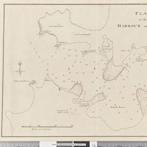
Metal Print : Page 37c Plan of the harbour of St. Lucia


![]()
Metal Prints from Fine Art Finder
Page 37c Plan of the harbour of St. Lucia
5670304 Page 37c Plan of the harbour of St. Lucia by Unknown artist, (18th century); Mitchell Library, State Library of New South Wales; (add.info.: Original Sketches, Drawings, Maps etc Collected by Admiral Isaac Smith / drawings and watercolours, mainly of Captain Cooks Second Voyage (1772-1775) by William Hodges, Henry Roberts etc
Dimensions: Album measures 49 x 70 cm); Mitchell Library, State Library of New South Wales; out of copyright
Media ID 23584930
© Mitchell Library, State Library of New South Wales / Bridgeman Images
Caribbean Cartographic Compass Geographical Label Labelled Lesser Antilles Mapping Numbers Scale Survey Surveying
16"x20" (51x41cm) Metal Print
Bring the historical charm of the 18th century harbor of St. Lucia into your home or office with our Media Storehouse Metal Prints. Featuring the intricate Plan of the harbour of St. Lucia from Bridgeman Images, this fine art print showcases the detail and beauty of this Unknown artist's work from the Mitchell Library, State Library of New South Wales. Our high-quality metal prints are vibrant, waterproof, and scratch-resistant, ensuring your investment is protected while adding a touch of elegance and sophistication to any space. Experience the timeless allure of this historical plan with our premium metal print.
Made with durable metal and luxurious printing techniques, our metal photo prints go beyond traditional canvases, adding a cool, modern touch to your space. Wall mount on back. Eco-friendly 100% post-consumer recycled ChromaLuxe aluminum surface. The thickness of the print is 0.045". Featuring a Scratch-resistant surface and Rounded corners. Backing hangers are attached to the back of the print and float the print 1/2-inch off the wall when hung, the choice of hanger may vary depending on size and International orders will come with Float Mount hangers only. Finished with a brilliant white high gloss surface for unsurpassed detail and vibrance. Printed using Dye-Sublimation and for best care we recommend a non-ammonia glass cleaner, water, or isopropyl (rubbing) alcohol to prevent harming the print surface. We recommend using a clean, lint-free cloth to wipe off the print. The ultra-hard surface is scratch-resistant, waterproof and weatherproof. Avoid direct sunlight exposure.
Made with durable metal and luxurious printing techniques, metal prints bring images to life and add a modern touch to any space
Estimated Image Size (if not cropped) is 50.8cm x 40.6cm (20" x 16")
Estimated Product Size is 51.4cm x 41.2cm (20.2" x 16.2")
These are individually made so all sizes are approximate
Artwork printed orientated as per the preview above, with landscape (horizontal) orientation to match the source image.
FEATURES IN THESE COLLECTIONS
> Fine Art Finder
> Artists
> Unknown Artist
> Fine Art Finder
> Artists
> William Hodges
> Arts
> Artists
> H
> William Hodges
> Arts
> Artists
> K
> Henry Key
> Arts
> Artists
> M
> Robert Mitchell
> Arts
> Artists
> P
> William Page
> Arts
> Artists
> Related Images
> Arts
> Artists
> S
> Robert Smith
> Europe
> United Kingdom
> Wales
> Maps
> Europe
> United Kingdom
> Wales
> Posters
> Europe
> United Kingdom
> Wales
> Related Images
EDITORS COMMENTS
This print showcases "Page 37c Plan of the harbour of St. Lucia" a remarkable piece of cartography from the 18th century. Created by an unknown artist, this map is part of the collection held at Mitchell Library, State Library of New South Wales. The album measures an impressive 49 x 70 cm and features original sketches, drawings, maps, and more collected by Admiral Isaac Smith. The intricately detailed drawing depicts the coastline and shoreline of St. Lucia's harbor with precision and accuracy. Labeled with numbers and accompanied by a key, compass, and scale, this map offers valuable insights into the geography and topography of the Caribbean region during that time. As we delve into its rich history, we are transported back to Captain Cook's Second Voyage (1772-1775), as it includes drawings and watercolors by renowned artists such as William Hodges and Henry Roberts. This fascinating artifact not only serves as a testament to the artistry involved in cartographic surveying but also provides invaluable information about maritime exploration in the XVIIIth century Lesser Antilles region. With its coastal charm and nautical allure, this print captures our imagination while reminding us of centuries past when brave explorers set sail on daring expeditions to uncover new lands.
MADE IN THE USA
Safe Shipping with 30 Day Money Back Guarantee
FREE PERSONALISATION*
We are proud to offer a range of customisation features including Personalised Captions, Color Filters and Picture Zoom Tools
SECURE PAYMENTS
We happily accept a wide range of payment options so you can pay for the things you need in the way that is most convenient for you
* Options may vary by product and licensing agreement. Zoomed Pictures can be adjusted in the Cart.