Metal Print > North America > Related Images
Metal Print : Fort Monroe and its environs


![]()
Metal Prints from Fine Art Storehouse
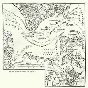
Fort Monroe and its environs
Vintage engraving from 1863 of a map of Fort Monroe and its environs. Fort Monroe played an important role in the American Civil War. It was held by Union forces throughout the Civil War, which launched several sea and land expeditions from there
Unleash your creativity and transform your space into a visual masterpiece!
duncan1890
Media ID 14757184
© duncan1890
American Civil War American Culture Chart Civil War Coastal Feature Document Eastern Usa Equipment Fort Historical War Event Illustrations And Vector Art Image Created 1860 1869 Information Equipment Land Land Feature Maryland Mid Atlantic Usa Navigational Equipment Norfolk Objects Equipment Past Plan Printed Media Styles Traditional Culture Travel Locations Virginia Chesapeake Bay Image Created 19th Century James River Monroe Obsolete The Hamptons
16"x24" (61x41cm) Metal Print
Step back in time with our stunning Metal Print of Fort Monroe and its environs by duncan1890 from the Media Storehouse Fine Art collection. This vintage engraving, originally created in 1863, offers a captivating glimpse into the historical significance of Fort Monroe during the American Civil War. The metallic finish adds a modern and sophisticated touch to this timeless piece, making it an excellent addition to any home or office decor. Bring history to life with this unique and intriguing work of art.
Made with durable metal and luxurious printing techniques, our metal photo prints go beyond traditional canvases, adding a cool, modern touch to your space. Wall mount on back. Eco-friendly 100% post-consumer recycled ChromaLuxe aluminum surface. The thickness of the print is 0.045". Featuring a Scratch-resistant surface and Rounded corners. Backing hangers are attached to the back of the print and float the print 1/2-inch off the wall when hung, the choice of hanger may vary depending on size and International orders will come with Float Mount hangers only. Finished with a brilliant white high gloss surface for unsurpassed detail and vibrance. Printed using Dye-Sublimation and for best care we recommend a non-ammonia glass cleaner, water, or isopropyl (rubbing) alcohol to prevent harming the print surface. We recommend using a clean, lint-free cloth to wipe off the print. The ultra-hard surface is scratch-resistant, waterproof and weatherproof. Avoid direct sunlight exposure.
Made with durable metal and luxurious printing techniques, metal prints bring images to life and add a modern touch to any space
Estimated Product Size is 41.2cm x 61.5cm (16.2" x 24.2")
These are individually made so all sizes are approximate
Artwork printed orientated as per the preview above, with portrait (vertical) orientation to match the source image.
FEATURES IN THESE COLLECTIONS
> Fine Art Storehouse
> History
> Battles & Wars
> American Civil War (1860-1865)
> Fine Art Storehouse
> History
> Battles & Wars
> Historcal Battle Maps and Plans
> Fine Art Storehouse
> Map
> Historical Maps
> Fine Art Storehouse
> Map
> USA Maps
> North America
> Related Images
EDITORS COMMENTS
This vintage engraving from 1863 showcases a meticulously detailed map of Fort Monroe and its environs. A significant historical artifact, this print offers a glimpse into the important role played by Fort Monroe during the American Civil War. Throughout the war, Union forces held this strategic fortification, launching numerous sea and land expeditions from its shores. The image itself exudes an air of antiquity with its woodcut style and engraved details. It transports us back to the 19th century, capturing the essence of that era's cartography. The print depicts not only Fort Monroe but also highlights various coastal features such as the James River and Chesapeake Bay. As we delve into this piece of history, we are reminded of how maps served as crucial navigational tools in a time when technology was limited. This document provides valuable information about travel locations, landmarks, and even built structures like forts. Beyond its practical purpose, this engraving reflects American culture at that time – traditional values intertwined with military prowess. It serves as a testament to our nation's past struggles and triumphs during one of its most defining events: the Civil War. With Maryland and Virginia forming part of its backdrop, this print captures both mid-Atlantic beauty and historical significance. As we admire this antique artwork today, it stands as a reminder of our rich heritage while offering insight into an obsolete yet fascinating era in American history.
MADE IN THE USA
Safe Shipping with 30 Day Money Back Guarantee
FREE PERSONALISATION*
We are proud to offer a range of customisation features including Personalised Captions, Color Filters and Picture Zoom Tools
SECURE PAYMENTS
We happily accept a wide range of payment options so you can pay for the things you need in the way that is most convenient for you
* Options may vary by product and licensing agreement. Zoomed Pictures can be adjusted in the Cart.