Metal Print > Fine Art Storehouse > Map
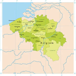
Metal Print : Holland and Belgium map 1875 and Belgium map 1875


![]()
Metal Prints from Fine Art Storehouse
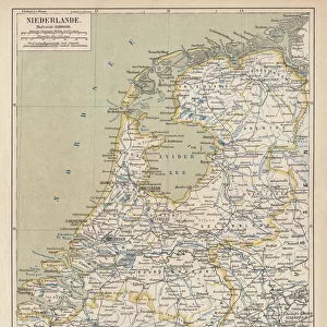
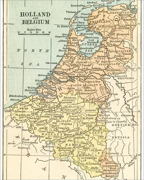
Holland and Belgium map 1875 and Belgium map 1875
The Independent Course Comprehensive Geography by James Monteith, A.S. Barnes & Co, New York & Chicago 1875
Unleash your creativity and transform your space into a visual masterpiece!
THEPALMER
Media ID 13612207
© This content is subject to copyright
Belgium Globe Navigational Equipment Holland Netherlands Paper Drawing Art Product
16"x20" (51x41cm) Metal Print
Step back in time with our stunning Metal Prints featuring intricately detailed maps of Holland and Belgium from 1875. These vintage cartography pieces, sourced from The Independent Course in Comprehensive Geography by James Monteith, are meticulously reproduced onto high-quality metal sheets. The vivid colors and impressive detail bring history to life, making these prints a unique addition to any home or office decor. Discover the rich history of these regions with our Holland and Belgium 1875 Metal Prints from Media Storehouse's Fine Art collection.
Made with durable metal and luxurious printing techniques, our metal photo prints go beyond traditional canvases, adding a cool, modern touch to your space. Wall mount on back. Eco-friendly 100% post-consumer recycled ChromaLuxe aluminum surface. The thickness of the print is 0.045". Featuring a Scratch-resistant surface and Rounded corners. Backing hangers are attached to the back of the print and float the print 1/2-inch off the wall when hung, the choice of hanger may vary depending on size and International orders will come with Float Mount hangers only. Finished with a brilliant white high gloss surface for unsurpassed detail and vibrance. Printed using Dye-Sublimation and for best care we recommend a non-ammonia glass cleaner, water, or isopropyl (rubbing) alcohol to prevent harming the print surface. We recommend using a clean, lint-free cloth to wipe off the print. The ultra-hard surface is scratch-resistant, waterproof and weatherproof. Avoid direct sunlight exposure.
Made with durable metal and luxurious printing techniques, metal prints bring images to life and add a modern touch to any space
Estimated Image Size (if not cropped) is 40.6cm x 50.8cm (16" x 20")
Estimated Product Size is 41.2cm x 51.4cm (16.2" x 20.2")
These are individually made so all sizes are approximate
Artwork printed orientated as per the preview above, with portrait (vertical) orientation to match the source image.
FEATURES IN THESE COLLECTIONS
> Fine Art Storehouse
> The Magical World of Illustration
> Palmer Illustrated Collection
> Fine Art Storehouse
> Map
> Historical Maps
EDITORS COMMENTS
This print takes us back in time to the year 1875, showcasing a detailed map of Holland and Belgium. The map is an exquisite piece from "The Independent Course Comprehensive Geography" by James Monteith, published by A. S. Barnes & Co in New York and Chicago during that era. The image transports us to a world where cartography was meticulously crafted through engraving and etching techniques on paper. It showcases the artistry involved in creating maps before the age of digital technology. With its vertical orientation, this antique map offers a glimpse into the physical geography of both countries. Every line, contour, and border has been intricately drawn to provide accurate representation. As we observe this historical artifact, it becomes evident that it serves as more than just navigational equipment; it is also a work of art. The engraved image captures our attention with its fine details and delicate craftsmanship. "The Holland and Belgium Map 1875" invites us to appreciate the rich history embedded within these lands while marveling at the skillful execution of cartographic illustration over a century ago. THEPALMER's expertise in capturing this remarkable print ensures that viewers can relish in its beauty today. This print allows us to cherish not only the historical significance but also THEPALMER's talent for preserving such timeless works for generations to come.
MADE IN THE USA
Safe Shipping with 30 Day Money Back Guarantee
FREE PERSONALISATION*
We are proud to offer a range of customisation features including Personalised Captions, Color Filters and Picture Zoom Tools
SECURE PAYMENTS
We happily accept a wide range of payment options so you can pay for the things you need in the way that is most convenient for you
* Options may vary by product and licensing agreement. Zoomed Pictures can be adjusted in the Cart.