Metal Print > North America > United States of America > New York > New York > Maps
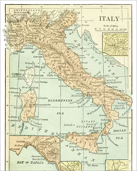
Metal Print : Italy map 1875


![]()
Metal Prints from Fine Art Storehouse
Italy map 1875
The Independent Course Comprehensive Geography by James Monteith, A.S. Barnes & Co, New York & Chicago 1875
Unleash your creativity and transform your space into a visual masterpiece!
THEPALMER
Media ID 13612227
© This content is subject to copyright
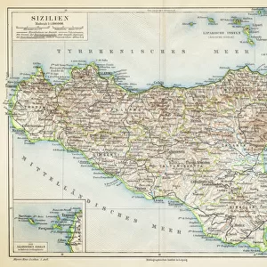
Globe Navigational Equipment Paper Sicily Drawing Art Product
16"x20" (51x41cm) Metal Print
Step back in time with our exquisite Metal Print of the Italy map from 1875, meticulously sourced from The Independent Course in Comprehensive Geography by James Monteith. This vintage map, published by A.S. Barnes & Co in New York & Chicago, showcases intricate detail and historical accuracy. Our high-quality Metal Prints bring the rich history of cartography to your home or office, with a modern and sleek design. The vibrant colors and durable finish ensure that your new addition will be a conversation starter for years to come. Experience the beauty of the past with our Italy Map 1875 Metal Print from Media Storehouse's Fine Art Collection.
Made with durable metal and luxurious printing techniques, our metal photo prints go beyond traditional canvases, adding a cool, modern touch to your space. Wall mount on back. Eco-friendly 100% post-consumer recycled ChromaLuxe aluminum surface. The thickness of the print is 0.045". Featuring a Scratch-resistant surface and Rounded corners. Backing hangers are attached to the back of the print and float the print 1/2-inch off the wall when hung, the choice of hanger may vary depending on size and International orders will come with Float Mount hangers only. Finished with a brilliant white high gloss surface for unsurpassed detail and vibrance. Printed using Dye-Sublimation and for best care we recommend a non-ammonia glass cleaner, water, or isopropyl (rubbing) alcohol to prevent harming the print surface. We recommend using a clean, lint-free cloth to wipe off the print. The ultra-hard surface is scratch-resistant, waterproof and weatherproof. Avoid direct sunlight exposure.
Made with durable metal and luxurious printing techniques, metal prints bring images to life and add a modern touch to any space
Estimated Image Size (if not cropped) is 40.6cm x 50.8cm (16" x 20")
Estimated Product Size is 41.2cm x 51.4cm (16.2" x 20.2")
These are individually made so all sizes are approximate
Artwork printed orientated as per the preview above, with portrait (vertical) orientation to match the source image.
FEATURES IN THESE COLLECTIONS
> Fine Art Storehouse
> The Magical World of Illustration
> Palmer Illustrated Collection
> Fine Art Storehouse
> Map
> Historical Maps
> Fine Art Storehouse
> Map
> Italian Maps
> Europe
> Italy
> Related Images
> Europe
> Italy
> Sicily
> Related Images
> Europe
> Related Images
> Maps and Charts
> Italy
> Maps and Charts
> Related Images
> North America
> United States of America
> Maps
> North America
> United States of America
> New York
> New York
> Maps
> North America
> United States of America
> New York
> Related Images
EDITORS COMMENTS
This print showcases an exquisite piece of history - the Italy map from 1875. A true testament to the artistry and craftsmanship of its time, this map is a remarkable representation of Italy's geography as depicted in James Monteith's renowned work, "The Independent Course Comprehensive Geography". Published by A. S. Barnes & Co in New York and Chicago, this particular edition holds immense historical significance. The intricate details etched onto paper through engraving techniques transport us back to a bygone era. Every contour and boundary line meticulously drawn with precision evokes a sense of awe for both nature's grandeur and human ingenuity. The delicate illustration captures not only the physical geography but also serves as a navigational tool, showcasing Sicily prominently alongside mainland Italy. As we gaze upon this antique masterpiece, we are reminded of the importance cartography held in shaping our understanding of the world during that period. This engraved image offers us a glimpse into how people perceived their surroundings over a century ago. "The Independent Course Comprehensive Geography" map transports us across continents while simultaneously connecting us to our own roots. It stands as an enduring symbol of exploration and discovery, inviting us to appreciate the beauty found within old maps' timeless allure. THEPALMER has masterfully captured this historic artifact through photography, allowing it to be cherished for generations to come.
MADE IN THE USA
Safe Shipping with 30 Day Money Back Guarantee
FREE PERSONALISATION*
We are proud to offer a range of customisation features including Personalised Captions, Color Filters and Picture Zoom Tools
SECURE PAYMENTS
We happily accept a wide range of payment options so you can pay for the things you need in the way that is most convenient for you
* Options may vary by product and licensing agreement. Zoomed Pictures can be adjusted in the Cart.