Metal Print > North America > United States of America > New York > New York > Maps
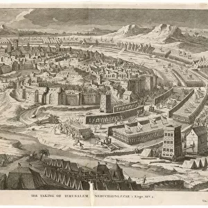
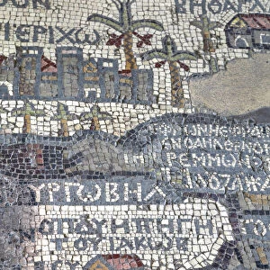
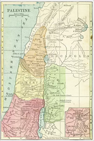
Metal Print : Palestine map 1875

![]()
Metal Prints from Fine Art Storehouse
Palestine map 1875
The Independent Course Comprehensive Geography by James Monteith, A.S. Barnes & Co, New York & Chicago 1875
Unleash your creativity and transform your space into a visual masterpiece!
THEPALMER
Media ID 13612199
© This content is subject to copyright
Globe Navigational Equipment Palestine Paper Drawing Art Product Palestinian Territories
16"x24" (61x41cm) Metal Print
Discover the rich history of Palestine with our stunning Metal Print of the 1875 Palestine map from THEPALMER, available at Media Storehouse's Fine Art Storehouse. This intricately detailed map, originally published in James Monteith's "The Independent Course of Study: Comprehensive Geography" by A.S. Barnes & Co, New York & Chicago, is brought to life through our premium metal print process. The vibrant colors and sharp lines pop against the sleek, modern metal surface, making this a beautiful addition to any home or office. Each print is carefully crafted with museum-quality materials to ensure longevity and durability. Transport yourself back in time and explore the history of Palestine with this unique and captivating piece of art.
Made with durable metal and luxurious printing techniques, our metal photo prints go beyond traditional canvases, adding a cool, modern touch to your space. Wall mount on back. Eco-friendly 100% post-consumer recycled ChromaLuxe aluminum surface. The thickness of the print is 0.045". Featuring a Scratch-resistant surface and Rounded corners. Backing hangers are attached to the back of the print and float the print 1/2-inch off the wall when hung, the choice of hanger may vary depending on size and International orders will come with Float Mount hangers only. Finished with a brilliant white high gloss surface for unsurpassed detail and vibrance. Printed using Dye-Sublimation and for best care we recommend a non-ammonia glass cleaner, water, or isopropyl (rubbing) alcohol to prevent harming the print surface. We recommend using a clean, lint-free cloth to wipe off the print. The ultra-hard surface is scratch-resistant, waterproof and weatherproof. Avoid direct sunlight exposure.
Made with durable metal and luxurious printing techniques, metal prints bring images to life and add a modern touch to any space
Estimated Product Size is 41.2cm x 61.5cm (16.2" x 24.2")
These are individually made so all sizes are approximate
Artwork printed orientated as per the preview above, with portrait (vertical) orientation to match the source image.
FEATURES IN THESE COLLECTIONS
> Fine Art Storehouse
> The Magical World of Illustration
> Palmer Illustrated Collection
> Fine Art Storehouse
> Map
> Historical Maps
> Asia
> Palestine
> Related Images
> Maps and Charts
> Related Images
> North America
> United States of America
> Maps
> North America
> United States of America
> New York
> New York
> Maps
> North America
> United States of America
> New York
> Related Images
EDITORS COMMENTS
This print showcases a historical gem, the "Palestine map 1875" from James Monteith's renowned book, "The Independent Course Comprehensive Geography". Published by A. S. Barnes & Co in New York and Chicago back in 1875, this exquisite piece of cartography takes us on a journey through time. The image captures the essence of an era when maps were meticulously hand-drawn and engraved with utmost precision. Displayed vertically against a backdrop of nature's beauty, this old paper print exudes an air of authenticity that transports us to the past. Its intricate details are brought to life through delicate etching and engraving techniques, showcasing the mastery of artistry during that period. As we gaze upon this antique masterpiece, our eyes are drawn to Palestine's geographical features depicted with great accuracy. This illustration serves as a valuable resource for understanding the physical geography of Palestinian territories at that time. "The Palestine map 1875" is not just an ordinary drawing; it represents a significant milestone in cartographic history. It reminds us how far we have come in terms of navigational equipment and mapping technologies since then. Courtesy of THEPALMER from Fine Art Storehouse, this print allows us to appreciate both its artistic value and historical significance. It serves as a reminder that art can transcend time and space while providing insight into our world's rich heritage.
MADE IN THE USA
Safe Shipping with 30 Day Money Back Guarantee
FREE PERSONALISATION*
We are proud to offer a range of customisation features including Personalised Captions, Color Filters and Picture Zoom Tools
SECURE PAYMENTS
We happily accept a wide range of payment options so you can pay for the things you need in the way that is most convenient for you
* Options may vary by product and licensing agreement. Zoomed Pictures can be adjusted in the Cart.