Metal Print > Arts > Artists > W > Charles White
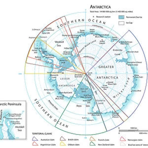
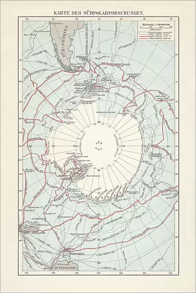
Metal Print : Antarctica map with sea routes of various explorers, lithograph, 1897

![]()
Metal Prints from Fine Art Storehouse
Antarctica map with sea routes of various explorers, lithograph, 1897
Historical map of the unexplored Antarctica with sea routes of various explorers, 18th - 19th century. Lithograph, published in 1897
Unleash your creativity and transform your space into a visual masterpiece!
ZU_09
Media ID 35843106
18th Century Adventure Antarctica Australia Explorer New Zealand Sea Passage South America South Pole Captain Cook Multi Colored White Color
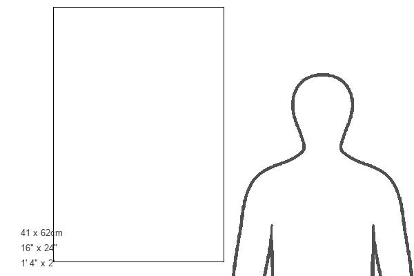
16"x24" (61x41cm) Metal Print
Step back in time with our stunning Antarctica Metal Print from Media Storehouse's Fine Art Collection. This historical lithograph, published in 1897, showcases an intricately detailed map of the unexplored Antarctica, marked with the sea routes of brave explorers from the 18th and 19th centuries. Each metal print is meticulously crafted to bring out the rich textures and vibrant colors of this captivating piece of history. Add a touch of adventure and nostalgia to your home or office decor with this unique and eye-catching Antarctica Metal Print.
Made with durable metal and luxurious printing techniques, our metal photo prints go beyond traditional canvases, adding a cool, modern touch to your space. Wall mount on back. Eco-friendly 100% post-consumer recycled ChromaLuxe aluminum surface. The thickness of the print is 0.045". Featuring a Scratch-resistant surface and Rounded corners. Backing hangers are attached to the back of the print and float the print 1/2-inch off the wall when hung, the choice of hanger may vary depending on size and International orders will come with Float Mount hangers only. Finished with a brilliant white high gloss surface for unsurpassed detail and vibrance. Printed using Dye-Sublimation and for best care we recommend a non-ammonia glass cleaner, water, or isopropyl (rubbing) alcohol to prevent harming the print surface. We recommend using a clean, lint-free cloth to wipe off the print. The ultra-hard surface is scratch-resistant, waterproof and weatherproof. Avoid direct sunlight exposure.
Made with durable metal and luxurious printing techniques, metal prints bring images to life and add a modern touch to any space
Estimated Product Size is 41.2cm x 61.5cm (16.2" x 24.2")
These are individually made so all sizes are approximate
Artwork printed orientated as per the preview above, with portrait (vertical) orientation to match the source image.
FEATURES IN THESE COLLECTIONS
> Fine Art Storehouse
> Map
> Historical Maps
> Arts
> Artists
> W
> Charles White
> Maps and Charts
> Early Maps
> Maps and Charts
> Related Images
> Oceania
> Australia
> Related Images
> Oceania
> New Zealand
> Maps
> Oceania
> New Zealand
> Related Images
> South America
> Related Images
EDITORS COMMENTS
This stunning lithograph, published in 1897, offers a captivating glimpse into the unexplored territories of Antarctica during the late 18th and 19th centuries. The map, adorned with a crisp white background, vividly depicts the icy continent with intricate detail, its vast expanses of ice and water shimmering in blues and whites. At the heart of the map lies the elusive South Pole, a blank space of uncharted territory, beckoning the brave and the curious. The map is a testament to the spirit of adventure and exploration that defined this era. It marks the sea routes of some of the most renowned explorers of the time, including Captain James Cook and Charles Wilkes. Cook's explorations in the Pacific Ocean brought him close to Antarctica, but he was unable to reach the continent. Wilkes, on the other hand, led the United States Exploring Expedition to Antarctica in the 1830s and charted significant portions of the Antarctic coastline. The map also reveals the connections between Antarctica and other parts of the world, with sea passages leading from the Atlantic and Indian Oceans to the Southern Ocean that surrounds Antarctica. The map's vertical orientation and multi-colored engraving add to its aesthetic appeal, making it a fascinating historical document that transports us back in time to an era of discovery and exploration.
MADE IN THE USA
Safe Shipping with 30 Day Money Back Guarantee
FREE PERSONALISATION*
We are proud to offer a range of customisation features including Personalised Captions, Color Filters and Picture Zoom Tools
SECURE PAYMENTS
We happily accept a wide range of payment options so you can pay for the things you need in the way that is most convenient for you
* Options may vary by product and licensing agreement. Zoomed Pictures can be adjusted in the Cart.