Metal Print > Europe > United Kingdom > Scotland > Scottish Borders > Selkirk
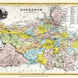
Metal Print : Antique map, Northumberland, Roxburgh, Cumberland 19th Century


![]()
Metal Prints from Fine Art Storehouse
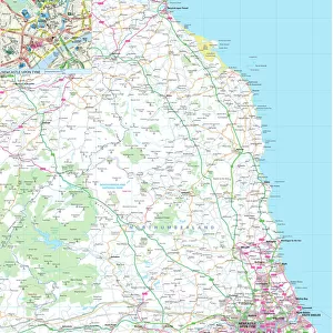
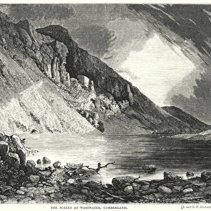
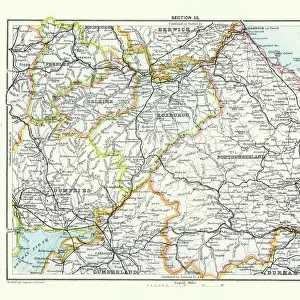
Antique map, Northumberland, Roxburgh, Cumberland 19th Century
Vintage engraving of a Antique map, Northumberland, Roxburgh, Cumberland, Dumfries, Selkirk, Berwick 19th Century
Unleash your creativity and transform your space into a visual masterpiece!
duncan1890
Media ID 15134757
© This content is subject to copyright
16"x20" (51x41cm) Metal Print
Step back in time with our stunning Media Storehouse Metal Print featuring an intricately detailed antique map of Northumberland, Roxburgh, Cumberland, Dumfries, Selkirk, and Berwick from the 19th century. This vintage engraving by duncan1890 from Fine Art Storehouse captures the historical essence of the region with its elegant lines and rich, authentic colors. The high-quality metal print process ensures vibrant, long-lasting colors and a distinctive, modern look. Bring history into your home or office with this beautiful and unique piece of art.
Made with durable metal and luxurious printing techniques, our metal photo prints go beyond traditional canvases, adding a cool, modern touch to your space. Wall mount on back. Eco-friendly 100% post-consumer recycled ChromaLuxe aluminum surface. The thickness of the print is 0.045". Featuring a Scratch-resistant surface and Rounded corners. Backing hangers are attached to the back of the print and float the print 1/2-inch off the wall when hung, the choice of hanger may vary depending on size and International orders will come with Float Mount hangers only. Finished with a brilliant white high gloss surface for unsurpassed detail and vibrance. Printed using Dye-Sublimation and for best care we recommend a non-ammonia glass cleaner, water, or isopropyl (rubbing) alcohol to prevent harming the print surface. We recommend using a clean, lint-free cloth to wipe off the print. The ultra-hard surface is scratch-resistant, waterproof and weatherproof. Avoid direct sunlight exposure.
Made with durable metal and luxurious printing techniques, metal prints bring images to life and add a modern touch to any space
Estimated Image Size (if not cropped) is 50.8cm x 40.6cm (20" x 16")
Estimated Product Size is 51.4cm x 41.2cm (20.2" x 16.2")
These are individually made so all sizes are approximate
Artwork printed orientated as per the preview above, with landscape (horizontal) orientation to match the source image.
FEATURES IN THESE COLLECTIONS
> Fine Art Storehouse
> Map
> Historical Maps
> Europe
> United Kingdom
> England
> Cumberland
> Europe
> United Kingdom
> England
> Northumberland
> Related Images
> Europe
> United Kingdom
> Scotland
> Dumfries and Galloway
> Dumfries
> Europe
> United Kingdom
> Scotland
> Dumfries and Galloway
> Related Images
> Europe
> United Kingdom
> Scotland
> Roxburghshire
> Europe
> United Kingdom
> Scotland
> Scottish Borders
> Selkirk
> Maps and Charts
> Related Images
EDITORS COMMENTS
This print takes us on a journey back in time to the 19th century, immersing us in the rich history of Northumberland, Roxburgh, Cumberland, Dumfries, Selkirk, and Berwick. The vintage engraving beautifully captures the intricate details of an antique map that once guided explorers and adventurers through these enchanting regions. As we gaze upon this piece from Fine Art Storehouse titled "Antique map, Northumberland, Roxburgh, Cumberland 19th Century" we can't help but be transported to a bygone era. The delicate lines and meticulous craftsmanship evoke a sense of awe for the cartographers who painstakingly created this masterpiece. The map showcases not only geographical features but also hints at the cultural heritage and significance of these areas. It invites us to explore hidden gems tucked away within ancient castles or meander along winding rivers that have witnessed centuries of stories unfold. Duncan1890's skillful capture ensures that every minute detail is preserved with utmost clarity. From faded ink markings denoting towns and villages to elegant calligraphy labeling mountain ranges and forests – each element tells its own tale. Whether you are an avid historian or simply appreciate artistry from yesteryears, this print serves as a remarkable conversation starter for any space it graces. Let yourself be captivated by the beauty of antiquity as you delve into the fascinating world depicted within "Antique map, Northumberland, Roxburgh, Cumberland 19th Century. "
MADE IN THE USA
Safe Shipping with 30 Day Money Back Guarantee
FREE PERSONALISATION*
We are proud to offer a range of customisation features including Personalised Captions, Color Filters and Picture Zoom Tools
SECURE PAYMENTS
We happily accept a wide range of payment options so you can pay for the things you need in the way that is most convenient for you
* Options may vary by product and licensing agreement. Zoomed Pictures can be adjusted in the Cart.