Metal Print > Arts > Landscape paintings > Landscape art > Landscape paintings
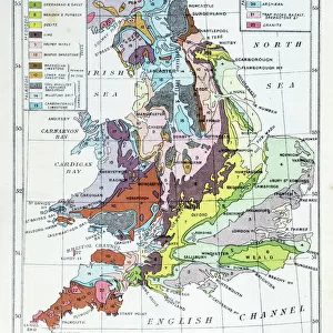
Metal Print : Geological map of southern Germany, Bohemia, Switzerland and Austria, published 1897


![]()
Metal Prints from Fine Art Storehouse
Geological map of southern Germany, Bohemia, Switzerland and Austria, published 1897
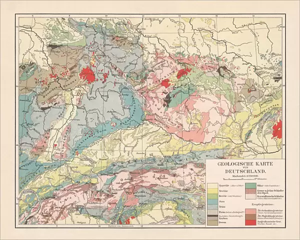
Geological map of southern and central Germany, Bohemia, Switzerland and Austria. Lithograph, published in 1897
Unleash your creativity and transform your space into a visual masterpiece!
Media ID 14756156
© This content is subject to copyright
Austria Bohemia Devon European Alps Geology Igneous Igneous Rock Slate Soil Switzerland Volcanic Carbon Geological Map Jura Minerals Multi Colored Quaternary Silurian Tertiary
16"x20" (51x41cm) Metal Print
Discover the rich geological history of Southern Germany, Bohemia, Switzerland, and Austria with our stunning Metal Print of the 1897 Geological Map. This beautiful lithograph, published over a century ago, showcases intricate details of the geological formations in the region. The high-quality metal print process brings out the vibrant colors and intricate lines of the map, making it a captivating addition to any home or office space. With its durable and waterproof finish, this print is not only a work of art but also a testament to the enduring fascination of geology. Bring a piece of historical cartography into your space and ignite curiosity with our Geological Map of Southern Germany, Bohemia, Switzerland, and Austria Metal Print from the Media Storehouse Fine Art Collection.
Made with durable metal and luxurious printing techniques, our metal photo prints go beyond traditional canvases, adding a cool, modern touch to your space. Wall mount on back. Eco-friendly 100% post-consumer recycled ChromaLuxe aluminum surface. The thickness of the print is 0.045". Featuring a Scratch-resistant surface and Rounded corners. Backing hangers are attached to the back of the print and float the print 1/2-inch off the wall when hung, the choice of hanger may vary depending on size and International orders will come with Float Mount hangers only. Finished with a brilliant white high gloss surface for unsurpassed detail and vibrance. Printed using Dye-Sublimation and for best care we recommend a non-ammonia glass cleaner, water, or isopropyl (rubbing) alcohol to prevent harming the print surface. We recommend using a clean, lint-free cloth to wipe off the print. The ultra-hard surface is scratch-resistant, waterproof and weatherproof. Avoid direct sunlight exposure.
Made with durable metal and luxurious printing techniques, metal prints bring images to life and add a modern touch to any space
Estimated Image Size (if not cropped) is 50.8cm x 40.6cm (20" x 16")
Estimated Product Size is 51.4cm x 41.2cm (20.2" x 16.2")
These are individually made so all sizes are approximate
Artwork printed orientated as per the preview above, with landscape (horizontal) orientation to match the source image.
FEATURES IN THESE COLLECTIONS
> Fine Art Storehouse
> Map
> Historical Maps
> Arts
> Landscape paintings
> Landscape art
> Landscape paintings
> Europe
> Austria
> Related Images
> Europe
> Germany
> Related Images
> Europe
> Switzerland
> Maps
> Europe
> Switzerland
> Posters
> Europe
> Switzerland
> Related Images
EDITORS COMMENTS
This lithograph, published in 1897, showcases a detailed geological map of southern Germany, Bohemia, Switzerland, and Austria. A true testament to the scientific advancements of its time, this print provides a glimpse into the rich history and diverse landscapes of these European regions. The intricate details on this map highlight various geological features that shaped the land over millions of years. From the towering peaks of the European Alps to the sprawling plains dotted with minerals and precious resources, every inch tells a story of Earth's evolution. Layers upon layers are unveiled as we explore this artwork - from quaternary deposits to ancient carbon formations; from Devonian rock formations to igneous outcrops; from slate quarries to Silurian sediments. The map also reveals significant periods such as Jura, Tertiary, Trias - each contributing unique characteristics to these lands. Vibrant colors bring life to this lithograph while providing visual cues about soil composition and volcanic activity across the region. Its horizontal layout allows for easy navigation through an array of information meticulously engraved onto its surface. As we gaze at this remarkable piece, it serves not only as a historical record but also as a reminder that beneath our feet lies an awe-inspiring tapestry woven by nature itself. Whether you're fascinated by geology or simply appreciate fine artistry capturing our planet's wonders – let this exquisite print transport you back in time and ignite your curiosity about Earth's magnificent past.
MADE IN THE USA
Safe Shipping with 30 Day Money Back Guarantee
FREE PERSONALISATION*
We are proud to offer a range of customisation features including Personalised Captions, Color Filters and Picture Zoom Tools
SECURE PAYMENTS
We happily accept a wide range of payment options so you can pay for the things you need in the way that is most convenient for you
* Options may vary by product and licensing agreement. Zoomed Pictures can be adjusted in the Cart.