Metal Print > Maps and Charts > Americas
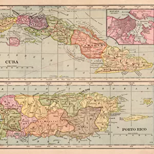
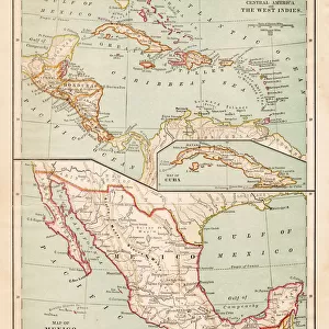
Metal Print : Map of Mexico and Central America 1889


![]()
Metal Prints from Fine Art Storehouse
Map of Mexico and Central America 1889
Indiana Educational Series The Complete Geography - Indianapolis 1889
Unleash your creativity and transform your space into a visual masterpiece!
THEPALMER
Media ID 14756356
© This content is subject to copyright
Caribbean Central America Cuba Dominican Republic Honduras Mexico Nicaragua Panama Puerto Rico West Indies
16"x24" (61x41cm) Metal Print
Discover the rich history and culture of Mexico and Central America with our stunning Metal Print of the Map of Mexico and Central America from 1889. This vintage map, part of the Indiana Educational Series The Complete Geography published in Indianapolis, showcases intricate details and accurate cartography of the region during that era. The high-quality Metal Print preserves the map's authenticity and vibrant colors, making it a unique and captivating addition to your home or office decor. Travel back in time and explore the historical significance of this beautiful region with our premium Metal Print from Media Storehouse's Fine Art Collection.
Made with durable metal and luxurious printing techniques, our metal photo prints go beyond traditional canvases, adding a cool, modern touch to your space. Wall mount on back. Eco-friendly 100% post-consumer recycled ChromaLuxe aluminum surface. The thickness of the print is 0.045". Featuring a Scratch-resistant surface and Rounded corners. Backing hangers are attached to the back of the print and float the print 1/2-inch off the wall when hung, the choice of hanger may vary depending on size and International orders will come with Float Mount hangers only. Finished with a brilliant white high gloss surface for unsurpassed detail and vibrance. Printed using Dye-Sublimation and for best care we recommend a non-ammonia glass cleaner, water, or isopropyl (rubbing) alcohol to prevent harming the print surface. We recommend using a clean, lint-free cloth to wipe off the print. The ultra-hard surface is scratch-resistant, waterproof and weatherproof. Avoid direct sunlight exposure.
Made with durable metal and luxurious printing techniques, metal prints bring images to life and add a modern touch to any space
Estimated Product Size is 61.5cm x 41.2cm (24.2" x 16.2")
These are individually made so all sizes are approximate
Artwork printed orientated as per the preview above, with landscape (horizontal) orientation to match the source image.
FEATURES IN THESE COLLECTIONS
> Fine Art Storehouse
> Map
> Historical Maps
> Maps and Charts
> Related Images
> North America
> Cuba
> Maps
> North America
> Cuba
> Related Images
> North America
> Dominican Republic
> Maps
> North America
> Dominican Republic
> Related Images
> North America
> Honduras
> Maps
> North America
> Honduras
> Related Images
> North America
> Mexico
> Maps
> North America
> Mexico
> Related Images
EDITORS COMMENTS
This print takes us back in time to the year 1889, when cartography was a true art form. The "Map of Mexico and Central America" is part of the esteemed Indiana Educational Series, specifically "The Complete Geography" which was published in Indianapolis during that era. With its intricate details and meticulous craftsmanship, this map offers a glimpse into the geographical landscape of an enchanting region. Stretching from Antillas to Cuba, West Indies to Caribbean, Dominican Republic to Honduras, Nicaragua to Panama, Puerto Rico and beyond - this map encompasses the vast territories that make up Mexico and Central America. Each line represents borders crossed by explorers and settlers alike; each contour showcases mountains climbed and rivers navigated throughout history. As we study this vintage masterpiece by THEPALMER at Fine Art Storehouse, we are transported back in time. We can almost imagine ourselves embarking on an adventurous journey through these lands as they were over a century ago. It serves as a reminder of how our world has evolved since then – politically, culturally, and geographically. Whether you have personal ties to these regions or simply appreciate the beauty of historical maps like this one, let it inspire your imagination. Let it remind you that beneath modern cities and bustling streets lie stories waiting to be discovered – tales etched into the very fabric of our planet's past.
MADE IN THE USA
Safe Shipping with 30 Day Money Back Guarantee
FREE PERSONALISATION*
We are proud to offer a range of customisation features including Personalised Captions, Color Filters and Picture Zoom Tools
SECURE PAYMENTS
We happily accept a wide range of payment options so you can pay for the things you need in the way that is most convenient for you
* Options may vary by product and licensing agreement. Zoomed Pictures can be adjusted in the Cart.