Metal Print > Europe > France > Paris > Maps
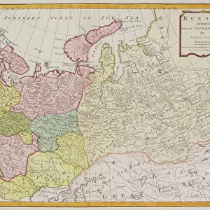
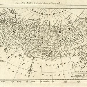
Metal Print : Map of the Russian Empire in Europe and Asia 1780


![]()
Metal Prints from Fine Art Storehouse
Map of the Russian Empire in Europe and Asia 1780
This is a map of the Russian Empire, a copperplate engraving from the Atlas de Toutes les Parties Connues du Globe Terrestre, Dresse Pour l Histoire Philosophique et Politique des Etablissemens et du Commerce des Europeens dans les deux Indes by Raynal and Bonne, published in Paris in 1780. Captions: Carte de l Empire de Russie en Europe et en Asia (Map of the Russian Empire in Europe and in Asia). Liv. V. No. 24. Long, du Meri, de Paris. Separate map scales are provided for Poland; the French community; marine; Dutch or German; Chinese, and Turkey
Unleash your creativity and transform your space into a visual masterpiece!
Whiteway
Media ID 15387387
© Whiteway
Copper Engraving Copperplate Engraving French Culture Image Created 18th Century Russia 1780 Russian Empire
16"x24" (61x41cm) Metal Print
Discover the rich history of the Russian Empire with our stunning Metal Print of the Map of Europe and Asia from 1780 by Whiteway. This intricately detailed copperplate engraving, originally from the Atlas de Toutes les Parties Connues du Globe Terrestre, showcases the vast expanse of the Russian Empire during this historic period. The high-quality Metal Print brings the map to life, with its vibrant colors and textures, making it a beautiful addition to any home or office. Relive the past and explore the history of one of the world's most influential empires with this exquisite piece of fine art.
Made with durable metal and luxurious printing techniques, our metal photo prints go beyond traditional canvases, adding a cool, modern touch to your space. Wall mount on back. Eco-friendly 100% post-consumer recycled ChromaLuxe aluminum surface. The thickness of the print is 0.045". Featuring a Scratch-resistant surface and Rounded corners. Backing hangers are attached to the back of the print and float the print 1/2-inch off the wall when hung, the choice of hanger may vary depending on size and International orders will come with Float Mount hangers only. Finished with a brilliant white high gloss surface for unsurpassed detail and vibrance. Printed using Dye-Sublimation and for best care we recommend a non-ammonia glass cleaner, water, or isopropyl (rubbing) alcohol to prevent harming the print surface. We recommend using a clean, lint-free cloth to wipe off the print. The ultra-hard surface is scratch-resistant, waterproof and weatherproof. Avoid direct sunlight exposure.
Made with durable metal and luxurious printing techniques, metal prints bring images to life and add a modern touch to any space
Estimated Product Size is 61.5cm x 41.2cm (24.2" x 16.2")
These are individually made so all sizes are approximate
Artwork printed orientated as per the preview above, with landscape (horizontal) orientation to match the source image.
FEATURES IN THESE COLLECTIONS
> Fine Art Storehouse
> Map
> Historical Maps
> Asia
> Turkey
> Related Images
> Europe
> France
> Paris
> Maps
> Europe
> Germany
> Paintings
EDITORS COMMENTS
This copperplate engraving, titled "Map of the Russian Empire in Europe and Asia 1780" offers a glimpse into the vastness and grandeur of the Russian Empire during the 18th century. Published in Paris as part of the Atlas de Toutes les Parties Connues du Globe Terrestre, this map was created for Raynal and Bonne's comprehensive work on European establishments and commerce in both Indies. The intricately detailed illustration showcases Russia's territorial expanse across two continents, with separate scales provided for various regions such as Poland, France, marine routes, Dutch or German territories, China, and Turkey. The vibrant colors bring life to this historical artifact while highlighting key geopolitical boundaries that shaped the empire at that time. As we observe this piece from Whiteway's collection at Fine Art Storehouse today, it not only serves as a valuable resource for historians but also provides insight into French culture during the era. This map represents an important intersection between artistry and cartography—a testament to human curiosity about distant lands and their political influence. Immerse yourself in history with this exquisite copper engraving—let your imagination wander through vast landscapes dotted with cities, rivers winding through unexplored territories, and trade routes connecting civilizations. It is a window into a bygone era when empires were expanding their reach across continents—a visual reminder of our collective past.
MADE IN THE USA
Safe Shipping with 30 Day Money Back Guarantee
FREE PERSONALISATION*
We are proud to offer a range of customisation features including Personalised Captions, Color Filters and Picture Zoom Tools
SECURE PAYMENTS
We happily accept a wide range of payment options so you can pay for the things you need in the way that is most convenient for you
* Options may vary by product and licensing agreement. Zoomed Pictures can be adjusted in the Cart.