Metal Print > Oceania > Australia > Maps
Metal Print : Map of South australia 1896


![]()
Metal Prints from Fine Art Storehouse
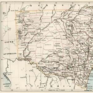
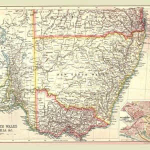
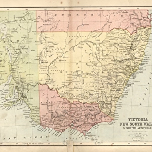
Map of South australia 1896
Andres Allgemeiner Handatlas - Bielefeld und Leipzig 1896
Unleash your creativity and transform your space into a visual masterpiece!
THEPALMER
Media ID 18356997
16"x24" (61x41cm) Metal Print
Discover the rich history of South Australia with our stunning Metal Print of the 1896 Map of South Australia by THEPALMER, from our Media Storehouse Fine Art collection. This intricately detailed map, taken from the Andres Allgemeiner Handatlas published in Bielefeld and Leipzig, showcases the historical boundaries, geographical features, and settlements of South Australia during that era. The high-quality Metal Print brings an elegant and timeless touch to any space, with its vibrant colors and crisp lines beautifully preserved on the durable metal surface. Transport yourself back in time and add a unique piece of historical art to your home or office decor.
Made with durable metal and luxurious printing techniques, our metal photo prints go beyond traditional canvases, adding a cool, modern touch to your space. Wall mount on back. Eco-friendly 100% post-consumer recycled ChromaLuxe aluminum surface. The thickness of the print is 0.045". Featuring a Scratch-resistant surface and Rounded corners. Backing hangers are attached to the back of the print and float the print 1/2-inch off the wall when hung, the choice of hanger may vary depending on size and International orders will come with Float Mount hangers only. Finished with a brilliant white high gloss surface for unsurpassed detail and vibrance. Printed using Dye-Sublimation and for best care we recommend a non-ammonia glass cleaner, water, or isopropyl (rubbing) alcohol to prevent harming the print surface. We recommend using a clean, lint-free cloth to wipe off the print. The ultra-hard surface is scratch-resistant, waterproof and weatherproof. Avoid direct sunlight exposure.
Made with durable metal and luxurious printing techniques, metal prints bring images to life and add a modern touch to any space
Estimated Product Size is 61.5cm x 41.2cm (24.2" x 16.2")
These are individually made so all sizes are approximate
Artwork printed orientated as per the preview above, with landscape (horizontal) orientation to match the source image.
FEATURES IN THESE COLLECTIONS
> Fine Art Storehouse
> Map
> Historical Maps
> Maps and Charts
> Related Images
EDITORS COMMENTS
This print showcases a historical gem, the "Map of South Australia 1896" taken from Andres Allgemeiner Handatlas - Bielefeld und Leipzig in 1896. A true testament to the artistry and precision of cartography, this vintage map transports us back to an era when exploration and discovery were at their peak. With intricate details etched onto its surface, this map offers a fascinating glimpse into the past. The borders of South Australia are clearly defined, displaying cities, towns, rivers, and mountain ranges that once shaped the landscape. Each stroke of ink tells a story of early settlement and development in this vast region. The sepia tones lend an air of nostalgia to this piece while adding depth and character. As we gaze upon it, we can't help but imagine what life was like during those times – horse-drawn carriages traversing dusty roads or pioneers embarking on daring adventures across uncharted territories. "The Map of South Australia 1896" is not just a mere representation; it's a portal into history itself. It serves as a reminder that our world is constantly evolving and that every inch has been explored by intrepid explorers who sought knowledge beyond their own horizons. Brought to you by THEPALMER through Fine Art Storehouse, this print captures both the beauty and significance of cartographic artistry. Whether displayed in your home or office space, it will undoubtedly spark conversations about our rich heritage while igniting wanderlust for those
MADE IN THE USA
Safe Shipping with 30 Day Money Back Guarantee
FREE PERSONALISATION*
We are proud to offer a range of customisation features including Personalised Captions, Color Filters and Picture Zoom Tools
SECURE PAYMENTS
We happily accept a wide range of payment options so you can pay for the things you need in the way that is most convenient for you
* Options may vary by product and licensing agreement. Zoomed Pictures can be adjusted in the Cart.