Metal Print > North America > United States of America > New York > New York > Maps
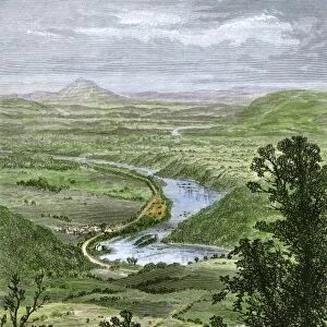
Metal Print : Mexico and Central America map of 1869


![]()
Metal Prints from Fine Art Storehouse
Mexico and Central America map of 1869
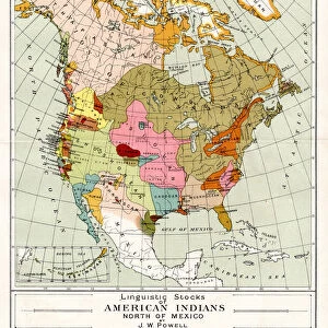
Cornells Grammar School Geography By S.S. Cornell - New York 1869
Unleash your creativity and transform your space into a visual masterpiece!
THEPALMER
Media ID 18106823
© 2014 Roberto Adrian Photography
16"x20" (51x41cm) Metal Print
Discover the rich history of Mexico and Central America with our stunning Metal Print of the 1869 Mexico and Central America map by THEPALMER from the Fine Art Storehouse collection. This intricately detailed map, originally published in S.S. Cornell's Cornells Grammar School Geography, transports you back in time. Each Metal Print is meticulously crafted, with vibrant colors and sharp lines that bring the map to life. The sleek, modern metal surface adds a contemporary twist to this classic piece of cartographic history. Perfect for adding a unique and educational touch to your home or office decor.
Made with durable metal and luxurious printing techniques, our metal photo prints go beyond traditional canvases, adding a cool, modern touch to your space. Wall mount on back. Eco-friendly 100% post-consumer recycled ChromaLuxe aluminum surface. The thickness of the print is 0.045". Featuring a Scratch-resistant surface and Rounded corners. Backing hangers are attached to the back of the print and float the print 1/2-inch off the wall when hung, the choice of hanger may vary depending on size and International orders will come with Float Mount hangers only. Finished with a brilliant white high gloss surface for unsurpassed detail and vibrance. Printed using Dye-Sublimation and for best care we recommend a non-ammonia glass cleaner, water, or isopropyl (rubbing) alcohol to prevent harming the print surface. We recommend using a clean, lint-free cloth to wipe off the print. The ultra-hard surface is scratch-resistant, waterproof and weatherproof. Avoid direct sunlight exposure.
Made with durable metal and luxurious printing techniques, metal prints bring images to life and add a modern touch to any space
Estimated Image Size (if not cropped) is 50.8cm x 40.6cm (20" x 16")
Estimated Product Size is 51.4cm x 41.2cm (20.2" x 16.2")
These are individually made so all sizes are approximate
Artwork printed orientated as per the preview above, with landscape (horizontal) orientation to match the source image.
FEATURES IN THESE COLLECTIONS
> Fine Art Storehouse
> Map
> Historical Maps
> Arts
> Artists
> M
> Mexican School Mexican School
> Maps and Charts
> Related Images
> North America
> Mexico
> Related Images
> North America
> United States of America
> New York
> New York
> Maps
> North America
> United States of America
> New York
> Related Images
EDITORS COMMENTS
This print takes us back in time to the year 1869, immersing us in the rich history of Mexico and Central America. The map, originally featured in "Cornells Grammar School Geography" by S. S. Cornell from New York, serves as a remarkable testament to the meticulous cartographic work of that era. As we gaze upon this vintage masterpiece, our eyes are immediately drawn to the intricate details meticulously etched onto its surface. The delicate lines trace the contours of each country, revealing their geographical boundaries with utmost precision. From Mexico's sprawling landscapes to Central America's enchanting archipelagos and isthmuses, every feature is captured with an artist's touch. The faded hues lend an air of nostalgia to this piece; they evoke a sense of discovery and wonder that must have accompanied explorers during those times. One can almost imagine intrepid adventurers poring over maps like these as they embarked on daring expeditions across uncharted territories. Beyond its historical significance lies a deeper appreciation for the artistry involved in creating such masterful works. This photograph allows us to admire not only the craftsmanship but also the dedication it took to produce such detailed representations without modern technology. "TheMexico and Central America map of 1869" transports us back through time, offering a glimpse into an era when exploration was at its peak and cartography was both science and art combined. It serves as a reminder that even within something as seemingly ordinary as a map lies beauty waiting patiently for our admiration.
MADE IN THE USA
Safe Shipping with 30 Day Money Back Guarantee
FREE PERSONALISATION*
We are proud to offer a range of customisation features including Personalised Captions, Color Filters and Picture Zoom Tools
SECURE PAYMENTS
We happily accept a wide range of payment options so you can pay for the things you need in the way that is most convenient for you
* Options may vary by product and licensing agreement. Zoomed Pictures can be adjusted in the Cart.