Metal Print > Europe > Netherlands > Maps
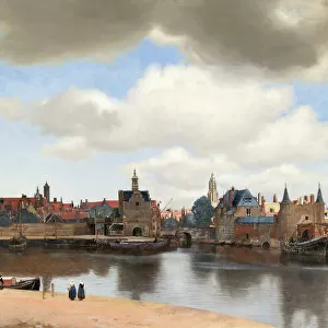
Metal Print : Old map of the Netherlands, steel engraving, published 1857


![]()
Metal Prints from Fine Art Storehouse
Old map of the Netherlands, steel engraving, published 1857
Old map of the Netherlands and Amsterdam. Steel engraving with hand coloured borderlines, published in 1857
Unleash your creativity and transform your space into a visual masterpiece!
ZU_09
Media ID 35842884
16"x20" (51x41cm) Metal Print
Step back in time with our exquisite Metal Print of an Old Map of the Netherlands and Amsterdam. This stunning steel engraving, published in 1857 by ZU_09, showcases intricate details of the Dutch landscape during an era of rich history. The antique map is adorned with hand-colored borderlines, adding an extra layer of charm and authenticity. Our high-quality Metal Print preserves the intricacies and textures of the original engraving, creating a timeless piece that adds character and depth to any space in your home or office. Elevate your decor with a touch of history and beauty. #OldMap #Netherlands #Amsterdam #SteelEngraving #VintageDecor #HomeDecor #OfficeDecor #FineArt
Made with durable metal and luxurious printing techniques, our metal photo prints go beyond traditional canvases, adding a cool, modern touch to your space. Wall mount on back. Eco-friendly 100% post-consumer recycled ChromaLuxe aluminum surface. The thickness of the print is 0.045". Featuring a Scratch-resistant surface and Rounded corners. Backing hangers are attached to the back of the print and float the print 1/2-inch off the wall when hung, the choice of hanger may vary depending on size and International orders will come with Float Mount hangers only. Finished with a brilliant white high gloss surface for unsurpassed detail and vibrance. Printed using Dye-Sublimation and for best care we recommend a non-ammonia glass cleaner, water, or isopropyl (rubbing) alcohol to prevent harming the print surface. We recommend using a clean, lint-free cloth to wipe off the print. The ultra-hard surface is scratch-resistant, waterproof and weatherproof. Avoid direct sunlight exposure.
Made with durable metal and luxurious printing techniques, metal prints bring images to life and add a modern touch to any space
Estimated Image Size (if not cropped) is 40.6cm x 50.8cm (16" x 20")
Estimated Product Size is 41.2cm x 51.4cm (16.2" x 20.2")
These are individually made so all sizes are approximate
Artwork printed orientated as per the preview above, with portrait (vertical) orientation to match the source image.
FEATURES IN THESE COLLECTIONS
> Fine Art Storehouse
> Map
> Historical Maps
> Europe
> Netherlands
> Amsterdam
> Europe
> Netherlands
> Maps
> Europe
> Netherlands
> Posters
> Europe
> Netherlands
> Related Images
> Maps and Charts
> Netherlands
EDITORS COMMENTS
This exquisite steel engraving showcases an old map of the Netherlands and Amsterdam, published in the year 1857. The intricate details of the map are brought to life through the meticulous hand-coloring of the borderlines, adding an elegant and antique charm to the piece. The map provides a fascinating glimpse into the geography and topography of the Netherlands during the mid-19th century. The intricate depiction of the country's waterways, including the Rhine, Meuse, and Waal rivers, highlights the Netherlands' unique relationship with water. The map also reveals the political divisions of the time, with the Dutch East Indies, now known as Indonesia, depicted as part of the Dutch colonial empire. Amsterdam, the capital city of the Netherlands, is prominently featured in the lower right corner of the map. The city's layout is meticulously detailed, with the canals, streets, and major landmarks clearly visible. The map also includes a key, which identifies various points of interest within the city, such as the Dam Square, the Royal Palace, and the Stock Exchange. This old map of the Netherlands and Amsterdam is not only a beautiful piece of art but also a historical document that offers valuable insights into the geography, politics, and culture of the Netherlands during the mid-19th century. The intricate steel engraving and hand-coloring techniques used to create this map add to its antique charm and make it a must-have for any collector of historical maps or art.
MADE IN THE USA
Safe Shipping with 30 Day Money Back Guarantee
FREE PERSONALISATION*
We are proud to offer a range of customisation features including Personalised Captions, Color Filters and Picture Zoom Tools
SECURE PAYMENTS
We happily accept a wide range of payment options so you can pay for the things you need in the way that is most convenient for you
* Options may vary by product and licensing agreement. Zoomed Pictures can be adjusted in the Cart.