Metal Print > Arts > Modern art pieces > Textures and patterns in modern > Modern paintings
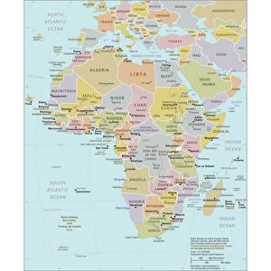
Metal Print : South America Physical map 1897


![]()
Metal Prints from Fine Art Storehouse
South America Physical map 1897
The World-Wide Atlas of Modern Geography, Political and Physical W. & A.K. Johnston - London 1897
Unleash your creativity and transform your space into a visual masterpiece!
THEPALMER
Media ID 14757130
© Roberto A Sanchez
Argentina Atlantic Ocean Atlas Backgrounds Brazil Colombia Country Geographic Area Direction Earth Latin America Pacific Ocean Paper Patina Sepia Toned South America Textured Effect Uruguay Venezuela World Map Retro Styled
16"x20" (51x41cm) Metal Print
Discover the rich history and geography of South America with our stunning Metal Print of the 1897 South America Physical Map by THEPALMER from Fine Art Storehouse. This vintage map, taken from The World-Wide Atlas of Modern Geography, Political and Physical W. & A.K. Johnston, London, transports you back in time with its intricate details and captivating design. The high-quality Metal Print not only showcases the physical features of South America but also adds a touch of vintage charm to any room. Order now and bring a piece of historical cartography into your home or office.
Made with durable metal and luxurious printing techniques, our metal photo prints go beyond traditional canvases, adding a cool, modern touch to your space. Wall mount on back. Eco-friendly 100% post-consumer recycled ChromaLuxe aluminum surface. The thickness of the print is 0.045". Featuring a Scratch-resistant surface and Rounded corners. Backing hangers are attached to the back of the print and float the print 1/2-inch off the wall when hung, the choice of hanger may vary depending on size and International orders will come with Float Mount hangers only. Finished with a brilliant white high gloss surface for unsurpassed detail and vibrance. Printed using Dye-Sublimation and for best care we recommend a non-ammonia glass cleaner, water, or isopropyl (rubbing) alcohol to prevent harming the print surface. We recommend using a clean, lint-free cloth to wipe off the print. The ultra-hard surface is scratch-resistant, waterproof and weatherproof. Avoid direct sunlight exposure.
Made with durable metal and luxurious printing techniques, metal prints bring images to life and add a modern touch to any space
Estimated Image Size (if not cropped) is 40.6cm x 50.8cm (16" x 20")
Estimated Product Size is 41.2cm x 51.4cm (16.2" x 20.2")
These are individually made so all sizes are approximate
Artwork printed orientated as per the preview above, with portrait (vertical) orientation to match the source image.
FEATURES IN THESE COLLECTIONS
> Fine Art Storehouse
> Map
> Historical Maps
> Arts
> Artists
> O
> Oceanic Oceanic
> Arts
> Modern art pieces
> Textures and patterns in modern
> Modern paintings
> Arts
> Modern art pieces
> Textures and patterns in modern
> Europe
> United Kingdom
> England
> London
> Politics
> Related Images
> Maps and Charts
> Related Images
> Maps and Charts
> World
> South America
> Argentina
> Maps
EDITORS COMMENTS
This print takes us back in time to the year 1897, when cartography was a meticulous art form. The South America Physical map featured in this image is part of "The World-Wide Atlas of Modern Geography, Political and Physical" by W. & A. K. Johnston - London 1897. With its retro-styled appearance and antique charm, this engraved image showcases the intricate details of South America's physical geography. From Venezuela to Uruguay, Colombia to Brazil, Argentina to every country within the region, each geographic area is meticulously depicted with precision and accuracy. The sepia-toned textured effect adds an extra layer of nostalgia, as if we are peering into a treasured relic from another era. As we gaze upon this piece, we can almost feel the texture of the paper and imagine how it would have been held in hands long ago. The vastness of South America unfolds before our eyes as we observe its borders stretching across both the Pacific Ocean and Atlantic Ocean. The sea surrounding these landmasses serves as a reminder of their connection to the rest of our planet Earth. Every line etched onto this map carries with it a sense of history—a patina that speaks volumes about exploration and discovery during that time period. This print by THEPALMER transports us back in time while simultaneously reminding us of the enduring beauty found within old maps like these.
MADE IN THE USA
Safe Shipping with 30 Day Money Back Guarantee
FREE PERSONALISATION*
We are proud to offer a range of customisation features including Personalised Captions, Color Filters and Picture Zoom Tools
SECURE PAYMENTS
We happily accept a wide range of payment options so you can pay for the things you need in the way that is most convenient for you
* Options may vary by product and licensing agreement. Zoomed Pictures can be adjusted in the Cart.