Metal Print > Asia > India > Maps
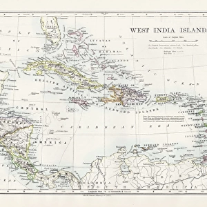
Metal Print : Vintage map of the West India Islands 1860s


![]()
Metal Prints from Fine Art Storehouse
Vintage map of the West India Islands 1860s
Unleash your creativity and transform your space into a visual masterpiece!
duncan1890
Media ID 13666613
© duncan1890
1860 1869 Antilles Bahamas Barbados Caribbean Caribbean Culture Cayman Islands Cuba Dominican Republic Ephemera Geographical Locations Greater Antilles Haiti Hispaniola Illustrations And Vector Art Image Created 1860 1869 Image Date Jamaica Lesser Antilles Navigational Equipment Pacific Islands Puerto Rico The Americas Travel Locations Trinidad And Tobago Turks And Caicos Islands West Indies Windward Islands Caribbean French Antilles Image Created 19th Century Leeward Islands Windward Islands
16"x20" (51x41cm) Metal Print
Step back in time with our exquisite Metal Print of a vintage map of the West India Islands from the 1860s, skillfully crafted by duncan1890 from our Media Storehouse Fine Art collection. This stunning piece of historical artistry is meticulously transferred onto a sturdy metal panel, ensuring a vibrant and long-lasting display. Bring the rich history of the West Indies into your home or office, and add a unique touch of character to any space. Order your Vintage Map of the West India Islands 1860s Metal Print today and let the stories of the past come alive in your world.
Made with durable metal and luxurious printing techniques, our metal photo prints go beyond traditional canvases, adding a cool, modern touch to your space. Wall mount on back. Eco-friendly 100% post-consumer recycled ChromaLuxe aluminum surface. The thickness of the print is 0.045". Featuring a Scratch-resistant surface and Rounded corners. Backing hangers are attached to the back of the print and float the print 1/2-inch off the wall when hung, the choice of hanger may vary depending on size and International orders will come with Float Mount hangers only. Finished with a brilliant white high gloss surface for unsurpassed detail and vibrance. Printed using Dye-Sublimation and for best care we recommend a non-ammonia glass cleaner, water, or isopropyl (rubbing) alcohol to prevent harming the print surface. We recommend using a clean, lint-free cloth to wipe off the print. The ultra-hard surface is scratch-resistant, waterproof and weatherproof. Avoid direct sunlight exposure.
Made with durable metal and luxurious printing techniques, metal prints bring images to life and add a modern touch to any space
Estimated Image Size (if not cropped) is 50.8cm x 40.6cm (20" x 16")
Estimated Product Size is 51.4cm x 41.2cm (20.2" x 16.2")
These are individually made so all sizes are approximate
Artwork printed orientated as per the preview above, with landscape (horizontal) orientation to match the source image.
FEATURES IN THESE COLLECTIONS
> Fine Art Storehouse
> Map
> Historical Maps
> Asia
> India
> Related Images
> Maps and Charts
> India
> Maps and Charts
> Related Images
> North America
> The Bahamas
> Maps
> North America
> The Bahamas
> Related Images
EDITORS COMMENTS
This vintage map of the West India Islands from the 1860s takes us on a journey back in time. With its intricate details and exquisite engraving, it showcases the beauty and cultural richness of the Caribbean region during that era. The map encompasses a vast area, stretching from the Leeward Islands to Labadee, capturing islands such as Turks and Caicos, Trinidad and Tobago, Haiti, Puerto Rico, Cuba, Jamaica, and many more. It offers a glimpse into the historical significance of these places within the context of trade routes and colonial influence. Painted with an illustration technique characteristic of the 19th century, this image serves as both a piece of artistry and an important historical document. Its depiction of navigational equipment adds another layer to its charm by reminding us of past exploration endeavors. As we explore this antique map further, we are transported to a time when cartography was not only about practicality but also about aesthetics. The attention to detail is evident in every stroke: from geographical locations meticulously marked to delicate illustrations scattered across landmasses. This print captures not just history but also evokes curiosity about how life might have been in these vibrant Caribbean islands over 150 years ago. It is truly a treasure for any lover of art or history seeking to delve into the enchanting world that once existed in this corner of "the Americas. "
MADE IN THE USA
Safe Shipping with 30 Day Money Back Guarantee
FREE PERSONALISATION*
We are proud to offer a range of customisation features including Personalised Captions, Color Filters and Picture Zoom Tools
SECURE PAYMENTS
We happily accept a wide range of payment options so you can pay for the things you need in the way that is most convenient for you
* Options may vary by product and licensing agreement. Zoomed Pictures can be adjusted in the Cart.