Metal Print > Aerial Photography > Related Images
Metal Print : Eugene Oregon US City Street Map

![]()
Metal Prints from Fine Art Storehouse
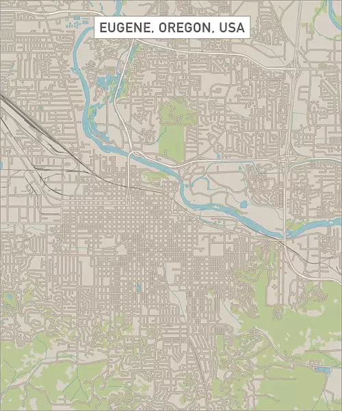
Eugene Oregon US City Street Map
Vector Illustration of a City Street Map of Eugene, Oregon, USA. Scale 1:60, 000.
All source data is in the public domain.
U.S. Geological Survey, US Topo
Used Layers:
USGS The National Map: National Hydrography Dataset (NHD)
USGS The National Map: National Transportation Dataset (NTD)
Unleash your creativity and transform your space into a visual masterpiece!
Frank Ramspott
Media ID 15055009
© Frank Ramspott, all rights reserved
Aerial View City Map Computer Graphic Directly Above Downtown District Gray Oregon Road Map Text Willamette River Digitally Generated Image Eugene White Color
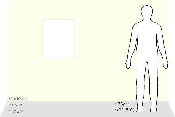
20"x24" (61x51cm) Metal Print
Discover the charm of Eugene, Oregon with our stunning Metal Print of the city street map by Frank Ramspott from Media Storehouse's Fine Art Storehouse. This exquisite vector illustration, featuring a 1:60,000 scale city map of Eugene, is meticulously crafted from public domain data. Transform your space with this unique and captivating representation of the US city, brought to life on high-quality metal. Experience the vibrant colors and intricate details that only a Metal Print can deliver. Add a touch of modern art and local pride to your home or office decor. Order yours today and bring the beauty of Eugene right to your walls.
Made with durable metal and luxurious printing techniques, our metal photo prints go beyond traditional canvases, adding a cool, modern touch to your space. Wall mount on back. Eco-friendly 100% post-consumer recycled ChromaLuxe aluminum surface. The thickness of the print is 0.045". Featuring a Scratch-resistant surface and Rounded corners. Backing hangers are attached to the back of the print and float the print 1/2-inch off the wall when hung, the choice of hanger may vary depending on size and International orders will come with Float Mount hangers only. Finished with a brilliant white high gloss surface for unsurpassed detail and vibrance. Printed using Dye-Sublimation and for best care we recommend a non-ammonia glass cleaner, water, or isopropyl (rubbing) alcohol to prevent harming the print surface. We recommend using a clean, lint-free cloth to wipe off the print. The ultra-hard surface is scratch-resistant, waterproof and weatherproof. Avoid direct sunlight exposure.
Made with durable metal and luxurious printing techniques, metal prints bring images to life and add a modern touch to any space
Estimated Image Size (if not cropped) is 50.8cm x 60.9cm (20" x 24")
Estimated Product Size is 51.4cm x 61.5cm (20.2" x 24.2")
These are individually made so all sizes are approximate
Artwork printed orientated as per the preview above, with portrait (vertical) orientation to match the source image.
FEATURES IN THESE COLLECTIONS
> Fine Art Storehouse
> Map
> Street Maps
> Fine Art Storehouse
> Map
> USA Maps
> Aerial Photography
> Related Images
> Arts
> Contemporary art
> Digital artwork
> Street art
> Arts
> Landscape paintings
> Waterfall and river artworks
> River artworks
> Arts
> Portraits
> Pop art gallery
> Street art portraits
> Arts
> Street art graffiti
> Digital art
> Digital paintings
> Arts
> Street art graffiti
> Digital art
> Vector illustrations
> Maps and Charts
> Geological Map
> Maps and Charts
> Related Images
> North America
> United States of America
> Lakes
> Related Images
> North America
> United States of America
> Maps
EDITORS COMMENTS
This print showcases a meticulously detailed city street map of Eugene, Oregon, USA. With a scale of 1:60,000, this vector illustration provides an accurate representation of the city's layout and features. The source data used to create this masterpiece is in the public domain and comes from reputable sources such as the U. S. Geological Survey and US Topo. The map highlights various elements that make Eugene unique and vibrant. From the meandering Willamette River to the bustling downtown district, every landmark is intricately depicted. The presence of lakes, rivers, streets, and roads adds depth to this comprehensive city map. Created using advanced cartography techniques and digitally generated imagery, this visually stunning artwork captures Eugene's essence with precision. The absence of people allows viewers to focus solely on exploring the urban landscape presented before them. Rendered in shades of gray with accents of blue and white text against a neutral background further enhances its aesthetic appeal. This aerial view directly above Eugene offers a fresh perspective on its physical geography while showcasing its well-planned road network. Ideal for both residents seeking familiar landmarks or visitors looking for guidance around town, this art piece by Frank Ramspott serves as an invaluable resource for anyone interested in discovering all that Eugene has to offer.
MADE IN THE USA
Safe Shipping with 30 Day Money Back Guarantee
FREE PERSONALISATION*
We are proud to offer a range of customisation features including Personalised Captions, Color Filters and Picture Zoom Tools
SECURE PAYMENTS
We happily accept a wide range of payment options so you can pay for the things you need in the way that is most convenient for you
* Options may vary by product and licensing agreement. Zoomed Pictures can be adjusted in the Cart.