Metal Print > Aerial Photography > Related Images
Metal Print : Santa Fe New Mexico US City Street Map


![]()
Metal Prints from Fine Art Storehouse
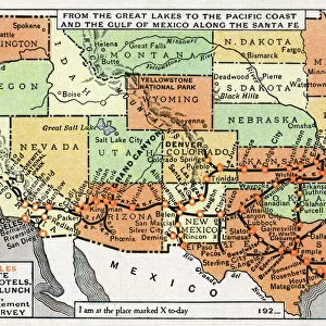
Santa Fe New Mexico US City Street Map
Vector Illustration of a City Street Map of Santa Fe, New Mexico, USA. Scale 1:60, 000.
All source data is in the public domain.
U.S. Geological Survey, US Topo
Used Layers:
USGS The National Map: National Hydrography Dataset (NHD)
USGS The National Map: National Transportation Dataset (NTD)
Unleash your creativity and transform your space into a visual masterpiece!
Frank Ramspott
Media ID 15215838
© Frank Ramspott, all rights reserved
Aerial View City Map Computer Graphic Directly Above Downtown District Gray New Mexico Road Map Text Digitally Generated Image Green Color Santa Fe White Color
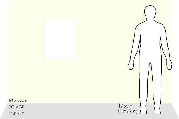
20"x24" (61x51cm) Metal Print
Discover the enchanting charm of Santa Fe, New Mexico with our Metal Print of the city street map by Frank Ramspott from Media Storehouse. This exquisite vector illustration, featuring a 1:60,000 scale representation of the city, is derived from public domain source data. Transform your space with this unique and captivating piece, meticulously printed on high-quality metal for a vibrant, long-lasting display. Bring the essence of Santa Fe right into your home or office, and let the magic of this historic city unfold before your eyes.
Made with durable metal and luxurious printing techniques, our metal photo prints go beyond traditional canvases, adding a cool, modern touch to your space. Wall mount on back. Eco-friendly 100% post-consumer recycled ChromaLuxe aluminum surface. The thickness of the print is 0.045". Featuring a Scratch-resistant surface and Rounded corners. Backing hangers are attached to the back of the print and float the print 1/2-inch off the wall when hung, the choice of hanger may vary depending on size and International orders will come with Float Mount hangers only. Finished with a brilliant white high gloss surface for unsurpassed detail and vibrance. Printed using Dye-Sublimation and for best care we recommend a non-ammonia glass cleaner, water, or isopropyl (rubbing) alcohol to prevent harming the print surface. We recommend using a clean, lint-free cloth to wipe off the print. The ultra-hard surface is scratch-resistant, waterproof and weatherproof. Avoid direct sunlight exposure.
Made with durable metal and luxurious printing techniques, metal prints bring images to life and add a modern touch to any space
Estimated Image Size (if not cropped) is 50.8cm x 60.9cm (20" x 24")
Estimated Product Size is 51.4cm x 61.5cm (20.2" x 24.2")
These are individually made so all sizes are approximate
Artwork printed orientated as per the preview above, with portrait (vertical) orientation to match the source image.
FEATURES IN THESE COLLECTIONS
> Fine Art Storehouse
> Map
> Street Maps
> Fine Art Storehouse
> Map
> USA Maps
> Fine Art Storehouse
> Travel Imagery
> Travel Destinations
> Santa Fe, New Mexico
> Aerial Photography
> Related Images
> Animals
> Insects
> Hemiptera
> Green Scale
> Arts
> Contemporary art
> Digital artwork
> Street art
> Arts
> Landscape paintings
> Waterfall and river artworks
> River artworks
> Arts
> Portraits
> Pop art gallery
> Street art portraits
> Arts
> Street art graffiti
> Digital art
> Digital paintings
> Arts
> Street art graffiti
> Digital art
> Vector illustrations
> Maps and Charts
> Geological Map
> Maps and Charts
> Related Images
> North America
> Mexico
> Lakes
> Related Images
EDITORS COMMENTS
This print showcases a meticulously crafted vector illustration of the enchanting city street map of Santa Fe, New Mexico. With a scale of 1:60,000, every intricate detail is brought to life in this stunning artwork. The source data used for this creation is derived from the public domain, specifically the U. S. Geological Survey and US Topo. The layers utilized include the USGS National Hydrography Dataset (NHD) and National Transportation Dataset (NTD), ensuring accuracy and precision in depicting the city's hydrographic features and transportation networks. From its downtown district to its serene lake and river, this image beautifully captures Santa Fe's essence. Rendered in vibrant colors such as gray, blue, white, and green, this digitally generated image provides an aerial view directly above Santa Fe. Its design seamlessly blends cartography with modern computer graphics techniques. With no people present in the scene, all attention is drawn towards exploring every corner of this visually striking city map. This fine art piece by Frank Ramspott serves as both a functional road map for navigation enthusiasts and an exquisite display of Santa Fe's physical geography
MADE IN THE USA
Safe Shipping with 30 Day Money Back Guarantee
FREE PERSONALISATION*
We are proud to offer a range of customisation features including Personalised Captions, Color Filters and Picture Zoom Tools
SECURE PAYMENTS
We happily accept a wide range of payment options so you can pay for the things you need in the way that is most convenient for you
* Options may vary by product and licensing agreement. Zoomed Pictures can be adjusted in the Cart.