Metal Print > Arts > Street art graffiti > Digital art > Vector illustrations
Metal Print : Torrance California US City Street Map


![]()
Metal Prints from Fine Art Storehouse
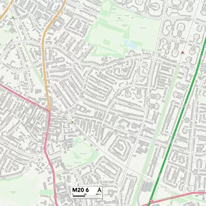
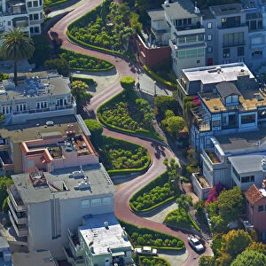
Torrance California US City Street Map
Vector Illustration of a City Street Map of Torrance, California, USA. Scale 1:60, 000.
All source data is in the public domain.
U.S. Geological Survey, US Topo
Used Layers:
USGS The National Map: National Hydrography Dataset (NHD)
USGS The National Map: National Transportation Dataset (NTD)
Unleash your creativity and transform your space into a visual masterpiece!
Frank Ramspott
Media ID 15055093
© Frank Ramspott, all rights reserved
Aerial View California City Map Computer Graphic Directly Above Downtown District Gray Pacific Ocean Road Map Text Digitally Generated Image Green Color Torrance White Color
20"x24" (61x51cm) Metal Print
Discover the charm of Torrance, California with our stunning Metal Print of a city street map by Frank Ramspott from Media Storehouse. This exquisite vector illustration, featuring a 1:60,000 scale City Street Map of Torrance, USA, is meticulously crafted from public domain source data. Transform your space with this unique and captivating piece, bringing the essence of Torrance right into your home or office. The sleek and modern Metal Print not only showcases the intricate details of the map but also adds a touch of sophistication and style. Explore the beauty of Torrance in a whole new way with Media Storehouse's Metal Print.
Made with durable metal and luxurious printing techniques, our metal photo prints go beyond traditional canvases, adding a cool, modern touch to your space. Wall mount on back. Eco-friendly 100% post-consumer recycled ChromaLuxe aluminum surface. The thickness of the print is 0.045". Featuring a Scratch-resistant surface and Rounded corners. Backing hangers are attached to the back of the print and float the print 1/2-inch off the wall when hung, the choice of hanger may vary depending on size and International orders will come with Float Mount hangers only. Finished with a brilliant white high gloss surface for unsurpassed detail and vibrance. Printed using Dye-Sublimation and for best care we recommend a non-ammonia glass cleaner, water, or isopropyl (rubbing) alcohol to prevent harming the print surface. We recommend using a clean, lint-free cloth to wipe off the print. The ultra-hard surface is scratch-resistant, waterproof and weatherproof. Avoid direct sunlight exposure.
Made with durable metal and luxurious printing techniques, metal prints bring images to life and add a modern touch to any space
Estimated Image Size (if not cropped) is 50.8cm x 60.9cm (20" x 24")
Estimated Product Size is 51.4cm x 61.5cm (20.2" x 24.2")
These are individually made so all sizes are approximate
Artwork printed orientated as per the preview above, with portrait (vertical) orientation to match the source image.
FEATURES IN THESE COLLECTIONS
> Fine Art Storehouse
> Map
> Street Maps
> Fine Art Storehouse
> Map
> USA Maps
> Aerial Photography
> Related Images
> Animals
> Insects
> Hemiptera
> Green Scale
> Animals
> Mammals
> Cricetidae
> California Mouse
> Arts
> Artists
> O
> Oceanic Oceanic
> Arts
> Contemporary art
> Digital artwork
> Street art
> Arts
> Landscape paintings
> Waterfall and river artworks
> River artworks
> Arts
> Portraits
> Pop art gallery
> Street art portraits
> Arts
> Street art graffiti
> Digital art
> Digital paintings
> Arts
> Street art graffiti
> Digital art
> Vector illustrations
> Maps and Charts
> Geological Map
EDITORS COMMENTS
This print showcases a meticulously detailed city street map of Torrance, California, USA. With a scale of 1:60,000, this vector illustration provides an accurate representation of the city's layout and infrastructure. The image encompasses various elements such as the Pacific Ocean glistening in the background, the bustling downtown district with its vibrant streets, and even a river and lake adding to the natural beauty of Torrance. Created using data from reliable sources like USGS The National Map: National Hydrography Dataset (NHD) and USGS The National Map: National Transportation Dataset (NTD), this digitally generated map is both visually stunning and informative. Its design incorporates shades of gray, green, blue, and white to highlight different features while maintaining clarity. The aerial view captured directly above allows viewers to appreciate the entirety of Torrance at once. This color image not only serves as an excellent tool for navigation but also offers a glimpse into the physical geography of this charming city. Displayed without any people present in order to focus solely on its cartographic details, this artwork by Frank Ramspott is perfect for those who appreciate fine craftsmanship in map-making. Whether you are a resident or visitor looking to explore Torrance or simply an admirer of beautiful maps, this print will undoubtedly add sophistication and elegance to any space it adorns.
MADE IN THE USA
Safe Shipping with 30 Day Money Back Guarantee
FREE PERSONALISATION*
We are proud to offer a range of customisation features including Personalised Captions, Color Filters and Picture Zoom Tools
SECURE PAYMENTS
We happily accept a wide range of payment options so you can pay for the things you need in the way that is most convenient for you
* Options may vary by product and licensing agreement. Zoomed Pictures can be adjusted in the Cart.