Metal Print > Europe > France > Canton > Maine
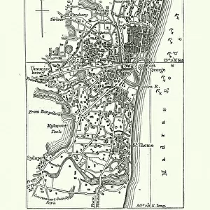
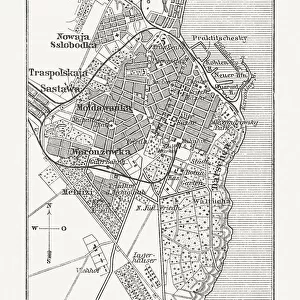
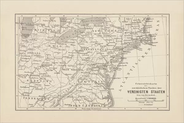
Metal Print : Map of Northeast United States, published in 1882


![]()
Metal Prints from Fine Art Storehouse
Map of Northeast United States, published in 1882
Map of the Northeast United States of America. Wood engraving, published in 1882
Unleash your creativity and transform your space into a visual masterpiece!
Media ID 13666947
© ZU_09
Connecticut East East Coast Indiana Kentucky Maine Maryland Maryland State Massachusetts Michigan New Hampshire New Jersey New York City New York State North North America North Carolina North Carolina Us State Ohio Pennsylvania Tennessee The Americas Vermont Virginia Virginia Us State Washington Dc Washington State West Virginia Wood Engraving
16"x24" (61x41cm) Metal Print
Step back in time with our vintage Map of the Northeast United States of America Metal Print from the Fine Art Storehouse. This beautiful wood engraving, published in 1882, showcases intricate details of the Northeastern region during an era of great historical significance. The metal print gives a modern twist to this classic piece, making it a unique addition to any home or office decor. Relive the history and charm of the past with this captivating piece from the Media Storehouse collection.
Made with durable metal and luxurious printing techniques, our metal photo prints go beyond traditional canvases, adding a cool, modern touch to your space. Wall mount on back. Eco-friendly 100% post-consumer recycled ChromaLuxe aluminum surface. The thickness of the print is 0.045". Featuring a Scratch-resistant surface and Rounded corners. Backing hangers are attached to the back of the print and float the print 1/2-inch off the wall when hung, the choice of hanger may vary depending on size and International orders will come with Float Mount hangers only. Finished with a brilliant white high gloss surface for unsurpassed detail and vibrance. Printed using Dye-Sublimation and for best care we recommend a non-ammonia glass cleaner, water, or isopropyl (rubbing) alcohol to prevent harming the print surface. We recommend using a clean, lint-free cloth to wipe off the print. The ultra-hard surface is scratch-resistant, waterproof and weatherproof. Avoid direct sunlight exposure.
Made with durable metal and luxurious printing techniques, metal prints bring images to life and add a modern touch to any space
Estimated Product Size is 61.5cm x 41.2cm (24.2" x 16.2")
These are individually made so all sizes are approximate
Artwork printed orientated as per the preview above, with landscape (horizontal) orientation to match the source image.
FEATURES IN THESE COLLECTIONS
> Fine Art Storehouse
> Map
> Historical Maps
> Fine Art Storehouse
> Map
> USA Maps
> Europe
> France
> Canton
> Maine
> Europe
> United Kingdom
> England
> Hampshire
> Related Images
> Maps and Charts
> Early Maps
> Maps and Charts
> Related Images
> North America
> Related Images
> North America
> United States of America
> Connecticut
> Related Images
> North America
> United States of America
> Indiana
> Related Images
> North America
> United States of America
> Kentucky
> Related Images
> North America
> United States of America
> Maine
> Related Images
EDITORS COMMENTS
This wood engraving, a Map of Northeast United States published in 1882, takes us on a journey through time to explore the intricate details of this antique cartographic masterpiece. The horizontal composition showcases the eastern region of North America, revealing an array of states that shaped the history and culture of the United States. From Washington D. C. to Washington State, from Maine to West Virginia, this map encompasses a vast territory filled with historical significance. Each state is meticulously etched into the woodcut with precision and artistry, capturing their unique shapes and boundaries. As we delve deeper into this ancient print, our eyes are drawn to prominent landmarks such as New York City's bustling metropolis or Pennsylvania's majestic mountains. The delicate lines and intricate patterns reveal not only geographical features but also provide insight into transportation routes and topographical variations. The absence of people in this image invites us to imagine how these landscapes might have appeared over a century ago - untamed wildernesses waiting for exploration or thriving cities brimming with life. This wood engraving serves as both an artistic treasure and a valuable historical artifact. It reminds us of the rich heritage embedded within these lands while showcasing the skillful craftsmanship employed by cartographers during that era. A true testament to human curiosity and ingenuity, this map offers endless opportunities for exploration and discovery even today.
MADE IN THE USA
Safe Shipping with 30 Day Money Back Guarantee
FREE PERSONALISATION*
We are proud to offer a range of customisation features including Personalised Captions, Color Filters and Picture Zoom Tools
SECURE PAYMENTS
We happily accept a wide range of payment options so you can pay for the things you need in the way that is most convenient for you
* Options may vary by product and licensing agreement. Zoomed Pictures can be adjusted in the Cart.