Metal Print > Arts > Artists > O > Oceanic Oceanic
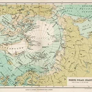
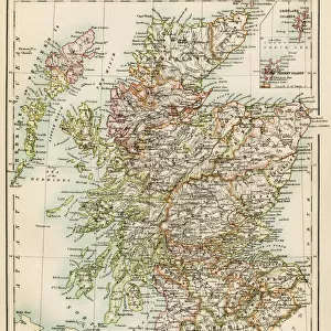
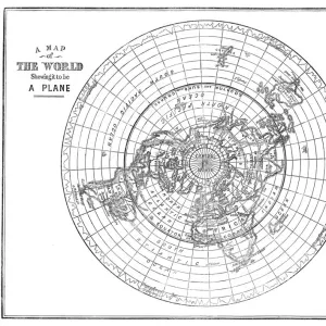
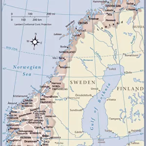
Metal Print : Ancient map of the Arctic Region, lithograph, published in 1883


![]()
Metal Prints from Fine Art Storehouse
Ancient map of the Arctic Region, lithograph, published in 1883
Ancient map of the Arctic Region. Lithograph, published in 1883
Unleash your creativity and transform your space into a visual masterpiece!
Media ID 13666939
© ZU_09
62990 78279 Alaska Us State Arctic Arctic Ocean Canada Circle Earth Ethnocultural History Globe Man Made Object Globe Navigational Equipment Greenland Island North Pole Norway Polar Climate Russia Scandinavia Siberia Spitsbergen Square Svalbard And Jan Mayen Topography World Map Bering Sea Globus Image Created 19th Century Northwest Passage
20"x24" (61x51cm) Metal Print
Step back in time with our captivating Ancient Arctic Map Metal Print from the Media Storehouse collection. This exquisite lithograph, published in 1883, offers a fascinating glimpse into the historical exploration of the Arctic region. With intricate details and vibrant colors, this metal print brings the past to life, making it a stunning addition to any home or office. The high-quality metal print preserves the intricacies of the original lithograph, ensuring a long-lasting and eye-catching display. Travel back in time and add a touch of history to your space with this beautiful Ancient Arctic Map Metal Print from Fine Art Storehouse.
Made with durable metal and luxurious printing techniques, our metal photo prints go beyond traditional canvases, adding a cool, modern touch to your space. Wall mount on back. Eco-friendly 100% post-consumer recycled ChromaLuxe aluminum surface. The thickness of the print is 0.045". Featuring a Scratch-resistant surface and Rounded corners. Backing hangers are attached to the back of the print and float the print 1/2-inch off the wall when hung, the choice of hanger may vary depending on size and International orders will come with Float Mount hangers only. Finished with a brilliant white high gloss surface for unsurpassed detail and vibrance. Printed using Dye-Sublimation and for best care we recommend a non-ammonia glass cleaner, water, or isopropyl (rubbing) alcohol to prevent harming the print surface. We recommend using a clean, lint-free cloth to wipe off the print. The ultra-hard surface is scratch-resistant, waterproof and weatherproof. Avoid direct sunlight exposure.
Made with durable metal and luxurious printing techniques, metal prints bring images to life and add a modern touch to any space
Estimated Image Size (if not cropped) is 50.8cm x 60.9cm (20" x 24")
Estimated Product Size is 51.4cm x 61.5cm (20.2" x 24.2")
These are individually made so all sizes are approximate
Artwork printed orientated as per the preview above, with portrait (vertical) orientation to match the source image.
FEATURES IN THESE COLLECTIONS
> Fine Art Storehouse
> Map
> Historical Maps
> Fine Art Storehouse
> Map
> USA Maps
> Fine Art Storehouse
> Travel Imagery
> Remote Places
> Svalbard, Norway
> Arts
> Artists
> O
> Oceanic Oceanic
> Europe
> Norway
> Related Images
> Europe
> Russia
> Related Images
> Maps and Charts
> Early Maps
EDITORS COMMENTS
This lithograph, published in 1883, unveils an ancient map of the Arctic Region, offering a glimpse into the world as it was over a century ago. The intricate details and exquisite craftsmanship of this engraved image transport us back to a time when cartography was both an art form and a scientific endeavor. The map showcases the vast expanse of the Arctic, with its polar climate and icy waters dominating the scene. From Asia's Siberia to Russia's Spitsbergen, from Norway's Scandinavia to Greenland in Europe, every corner is meticulously depicted. The Northwest Passage stands out prominently, symbolizing centuries of exploration and failed attempts at finding a navigable route through these treacherous waters. As we explore further, our eyes are drawn to North America's Alaska and Canada—two key players in the ethnocultural history of this region. Islands dotting the Arctic Ocean come alive on this historical document while reminding us of their significance in shaping global politics and trade routes. This lithograph not only serves as a window into our past but also highlights how humans have always sought knowledge about our planet. It reminds us that even before satellite imagery or GPS systems existed, intrepid explorers relied on maps like these for navigation across uncharted territories. With no people present within its borders, this ancient map invites us to ponder humanity's relationship with nature throughout history. As we gaze upon this remarkable piece of artistry created during the 19th century—a testament to human curiosity—we are
MADE IN THE USA
Safe Shipping with 30 Day Money Back Guarantee
FREE PERSONALISATION*
We are proud to offer a range of customisation features including Personalised Captions, Color Filters and Picture Zoom Tools
SECURE PAYMENTS
We happily accept a wide range of payment options so you can pay for the things you need in the way that is most convenient for you
* Options may vary by product and licensing agreement. Zoomed Pictures can be adjusted in the Cart.