Metal Print > Arts > Artists > B > Willem Blaeu
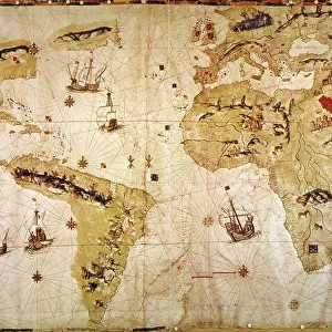
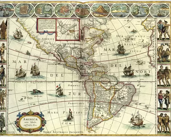
Metal Print : MAP: AMERICAS, c1630. A map of North and South America created by Dutch cartographer


![]()
Metal Prints from Granger
MAP: AMERICAS, c1630. A map of North and South America created by Dutch cartographer
MAP: AMERICAS, c1630.
A map of North and South America created by Dutch cartographer and atlas maker Willem Blaeu. Map, c1630
Granger holds millions of images spanning more than 25,000 years of world history, from before the Stone Age to the dawn of the Space Age
Media ID 12321418
1630 Atlas Blaeu Dutch Exploration New World North America South America Willem
16"x20" (51x41cm) Metal Print
Discover history with our stunning Metal Print of the MAP: AMERICAS, c1630. This captivating piece, sourced from The Granger Collection through Granger Art on Demand, showcases an intricately detailed map of North and South America. Created by Dutch cartographer Willem Blaeu in 1630, this vintage map brings the explorations of the New World to life. The high-quality Metal Print enhances the vibrant colors and intricate details, making it a perfect addition to any room in your home or office. Experience the rich history of the Americas like never before with this beautiful and unique decorative piece.
Made with durable metal and luxurious printing techniques, our metal photo prints go beyond traditional canvases, adding a cool, modern touch to your space. Wall mount on back. Eco-friendly 100% post-consumer recycled ChromaLuxe aluminum surface. The thickness of the print is 0.045". Featuring a Scratch-resistant surface and Rounded corners. Backing hangers are attached to the back of the print and float the print 1/2-inch off the wall when hung, the choice of hanger may vary depending on size and International orders will come with Float Mount hangers only. Finished with a brilliant white high gloss surface for unsurpassed detail and vibrance. Printed using Dye-Sublimation and for best care we recommend a non-ammonia glass cleaner, water, or isopropyl (rubbing) alcohol to prevent harming the print surface. We recommend using a clean, lint-free cloth to wipe off the print. The ultra-hard surface is scratch-resistant, waterproof and weatherproof. Avoid direct sunlight exposure.
Made with durable metal and luxurious printing techniques, metal prints bring images to life and add a modern touch to any space
Estimated Image Size (if not cropped) is 50.8cm x 40.6cm (20" x 16")
Estimated Product Size is 51.4cm x 41.2cm (20.2" x 16.2")
These are individually made so all sizes are approximate
Artwork printed orientated as per the preview above, with landscape (horizontal) orientation to match the source image.
FEATURES IN THESE COLLECTIONS
> Granger Art on Demand
> Maps
> Arts
> Artists
> B
> Willem Blaeu
> Maps and Charts
> Early Maps
> Maps and Charts
> Related Images
> Maps and Charts
> World
> South America
> Related Images
EDITORS COMMENTS
MAP: AMERICAS, c1630. A glimpse into the early exploration of the New World". This print showcases a remarkable map of North and South America, meticulously crafted by the renowned Dutch cartographer and atlas maker, Willem Blaeu. Created in 1630, this historic piece offers a fascinating window into the early days of exploration. As we delve into this intricately detailed map, we are transported back to a time when vast territories were yet to be fully discovered and understood. Every contour line and carefully placed landmark tells a story of intrepid explorers venturing into uncharted territories. Blaeu's expertise shines through as he captures both the grandeur and diversity of these two continents. From the rugged coastlines to majestic mountain ranges, every feature is rendered with precision and artistry. It is evident that his passion for cartography was matched only by his deep curiosity about these new lands. This extraordinary map serves not only as an invaluable historical artifact but also as a testament to human ingenuity and our insatiable thirst for knowledge. It reminds us that there was once a time when much of what we now take for granted remained undiscovered. Granger Art on Demand has preserved this remarkable piece from their collection, allowing us to marvel at its beauty centuries later. Let it transport you back in time as you explore the wonders depicted within its borders – an enduring tribute to Willem Blaeu's legacy in mapping the Americas.
MADE IN THE USA
Safe Shipping with 30 Day Money Back Guarantee
FREE PERSONALISATION*
We are proud to offer a range of customisation features including Personalised Captions, Color Filters and Picture Zoom Tools
SECURE PAYMENTS
We happily accept a wide range of payment options so you can pay for the things you need in the way that is most convenient for you
* Options may vary by product and licensing agreement. Zoomed Pictures can be adjusted in the Cart.