Metal Print > Historic > Ancient civilizations > Roman Empire > Roman art
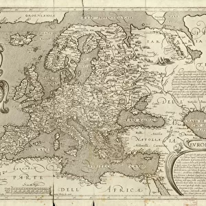
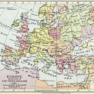
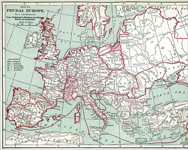
Metal Print : MAP OF EUROPE, 12th CENTURY. A 19th century map of Europe as it was politically constituted in the


![]()
Metal Prints from Granger
MAP OF EUROPE, 12th CENTURY. A 19th century map of Europe as it was politically constituted in the
MAP OF EUROPE, 12th CENTURY. A 19th century map of Europe as it was politically constituted in the 12th century
Granger holds millions of images spanning more than 25,000 years of world history, from before the Stone Age to the dawn of the Space Age
Media ID 6622533
12th Century Europe European Holy Roman Empire
16"x20" (51x41cm) Metal Print
Step back in time with our Media Storehouse Metal Print of a 12th century map of Europe. This captivating vintage reproduction, sourced from The Granger Collection at Granger Art on Demand, showcases Europe as it appeared during the Middle Ages. The intricate details of the map are brought to life through our high-quality metal print, creating a stunning and unique piece of decor for your home or office. Travel back in history and add a touch of ancient charm to your space with this beautifully detailed and historically significant map print.
Made with durable metal and luxurious printing techniques, our metal photo prints go beyond traditional canvases, adding a cool, modern touch to your space. Wall mount on back. Eco-friendly 100% post-consumer recycled ChromaLuxe aluminum surface. The thickness of the print is 0.045". Featuring a Scratch-resistant surface and Rounded corners. Backing hangers are attached to the back of the print and float the print 1/2-inch off the wall when hung, the choice of hanger may vary depending on size and International orders will come with Float Mount hangers only. Finished with a brilliant white high gloss surface for unsurpassed detail and vibrance. Printed using Dye-Sublimation and for best care we recommend a non-ammonia glass cleaner, water, or isopropyl (rubbing) alcohol to prevent harming the print surface. We recommend using a clean, lint-free cloth to wipe off the print. The ultra-hard surface is scratch-resistant, waterproof and weatherproof. Avoid direct sunlight exposure.
Made with durable metal and luxurious printing techniques, metal prints bring images to life and add a modern touch to any space
Estimated Image Size (if not cropped) is 50.8cm x 40.6cm (20" x 16")
Estimated Product Size is 51.4cm x 41.2cm (20.2" x 16.2")
These are individually made so all sizes are approximate
Artwork printed orientated as per the preview above, with landscape (horizontal) orientation to match the source image.
FEATURES IN THESE COLLECTIONS
> Granger Art on Demand
> Maps
> Arts
> Art Movements
> Medieval Art
> Arts
> Artists
> R
> Roman Roman
> Arts
> Landscape paintings
> Waterfall and river artworks
> River artworks
> Europe
> Related Images
> Historic
> Ancient civilizations
> Roman Empire
> Roman art
> Maps and Charts
> Related Images
EDITORS COMMENTS
This 19th century print showcases a meticulously detailed map of Europe, transporting us back to the political landscape of the 12th century. The artist's intricate craftsmanship allows us to explore the medieval boundaries and territories that shaped this ancient continent. The map highlights various kingdoms, principalities, and empires that dominated Europe during this era. One prominent feature is the Holy Roman Empire, which sprawls across central Europe with its vast influence and power. Its borders are clearly defined, emphasizing its significance as a dominant force in European politics. Rivers meander gracefully throughout the map, serving as vital trade routes connecting different regions and facilitating cultural exchange between diverse communities. These waterways were essential for transportation and played a crucial role in shaping economic growth during this period. As we delve into this historical masterpiece, we can't help but marvel at how much has changed over time. This print serves as a reminder of our rich heritage and offers an opportunity to reflect on the immense transformations that have occurred since then. Whether you're an avid history enthusiast or simply appreciate artistry at its finest, this Granger Collection print is sure to captivate your imagination and transport you back in time to witness Europe's political landscape during the enchanting 12th century.
MADE IN THE USA
Safe Shipping with 30 Day Money Back Guarantee
FREE PERSONALISATION*
We are proud to offer a range of customisation features including Personalised Captions, Color Filters and Picture Zoom Tools
SECURE PAYMENTS
We happily accept a wide range of payment options so you can pay for the things you need in the way that is most convenient for you
* Options may vary by product and licensing agreement. Zoomed Pictures can be adjusted in the Cart.