Metal Print > North America > Mexico > Maps
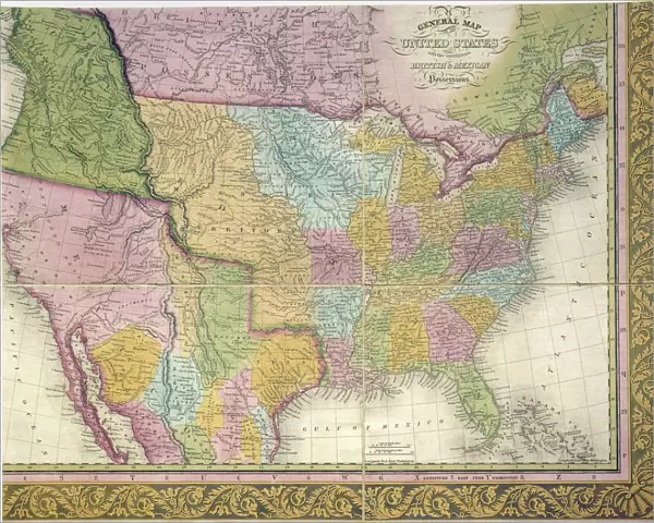
Metal Print : MAP: UNITED STATES, 1849. A General Map of the United States with the contiguous


![]()
Metal Prints from Granger
MAP: UNITED STATES, 1849. A General Map of the United States with the contiguous
MAP: UNITED STATES, 1849.
A General Map of the United States with the contiguous British & Mexican Possessions: engraved map published, 1849, by Samuel A. Mitchell at Philadelphia
Granger holds millions of images spanning more than 25,000 years of world history, from before the Stone Age to the dawn of the Space Age
Media ID 12321050
1849 Canada Latin America Mesoamerica Mexico United States
16"x20" (51x41cm) Metal Print
Discover history with our stunning Metal Prints featuring the "A General Map of the United States with the Contiguous British & Mexican Possessions," published in 1849 by Samuel A. Mitchell. This intricately detailed map showcases the United States as it looked during a pivotal period in American history. Each Metal Print is crafted with premium quality materials, ensuring vibrant colors and sharp details that bring history to life. Add a touch of history to your home or office with this beautiful and unique piece from Media Storehouse's range of Metal Prints.
Made with durable metal and luxurious printing techniques, our metal photo prints go beyond traditional canvases, adding a cool, modern touch to your space. Wall mount on back. Eco-friendly 100% post-consumer recycled ChromaLuxe aluminum surface. The thickness of the print is 0.045". Featuring a Scratch-resistant surface and Rounded corners. Backing hangers are attached to the back of the print and float the print 1/2-inch off the wall when hung, the choice of hanger may vary depending on size and International orders will come with Float Mount hangers only. Finished with a brilliant white high gloss surface for unsurpassed detail and vibrance. Printed using Dye-Sublimation and for best care we recommend a non-ammonia glass cleaner, water, or isopropyl (rubbing) alcohol to prevent harming the print surface. We recommend using a clean, lint-free cloth to wipe off the print. The ultra-hard surface is scratch-resistant, waterproof and weatherproof. Avoid direct sunlight exposure.
Made with durable metal and luxurious printing techniques, metal prints bring images to life and add a modern touch to any space
Estimated Image Size (if not cropped) is 50.8cm x 40.6cm (20" x 16")
Estimated Product Size is 51.4cm x 41.2cm (20.2" x 16.2")
These are individually made so all sizes are approximate
Artwork printed orientated as per the preview above, with landscape (horizontal) orientation to match the source image.
FEATURES IN THESE COLLECTIONS
> Granger Art on Demand
> Maps
> Maps and Charts
> Related Images
> North America
> Canada
> Maps
> North America
> Canada
> Related Images
> North America
> Mexico
> Maps
> North America
> Mexico
> Related Images
EDITORS COMMENTS
This print showcases a historical treasure, the "MAP: UNITED STATES, 1849". It is a remarkable representation of the United States during that era, meticulously engraved by Samuel A. Mitchell and published in Philadelphia in 1849. The map encompasses not only the contiguous states but also provides insight into the British and Mexican possessions at that time. As we delve into this piece of art, it transports us back to an important period in American history. With its intricate details and precise cartography, this map offers a glimpse into the vastness of America's expansion during the mid-19th century. From coast to coast, it captures every state with utmost accuracy. Beyond just depicting borders and territories, this map serves as a visual testament to America's influence on its neighboring regions. It highlights Canada to the north and various Latin American countries to the south, including Mexico and Mesoamerica. The inclusion of major rivers further enhances our understanding of how these waterways played crucial roles in shaping transportation routes and trade networks across different parts of America. Through this print from Granger Art on Demand, viewers can appreciate both the artistic beauty and historical significance encapsulated within this exquisite engraving. Whether you are an avid historian or simply intrigued by maps' ability to tell stories about our past, "MAP: UNITED STATES, 1849" is sure to captivate your imagination for hours on end.
MADE IN THE USA
Safe Shipping with 30 Day Money Back Guarantee
FREE PERSONALISATION*
We are proud to offer a range of customisation features including Personalised Captions, Color Filters and Picture Zoom Tools
SECURE PAYMENTS
We happily accept a wide range of payment options so you can pay for the things you need in the way that is most convenient for you
* Options may vary by product and licensing agreement. Zoomed Pictures can be adjusted in the Cart.