Metal Print > Arts > Artists > C > Samuel de Champlain
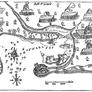
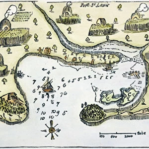
Metal Print : PLYMOUTH, MA, MAP 1605. Samuel de Champlains map of Port St. Louis, later settled by the English as Plymouth, Massachusetts, drawn during an expedetion of 1605


![]()
Metal Prints from Granger
PLYMOUTH, MA, MAP 1605. Samuel de Champlains map of Port St. Louis, later settled by the English as Plymouth, Massachusetts, drawn during an expedetion of 1605
PLYMOUTH, MA, MAP 1605.
Samuel de Champlains map of Port St. Louis, later settled by the English as Plymouth, Massachusetts, drawn during an expedetion of 1605
Granger holds millions of images spanning more than 25,000 years of world history, from before the Stone Age to the dawn of the Space Age
Media ID 6622567
1605 Champlain Colony Samuel Settlement Topography Wood Cut
16"x20" (51x41cm) Metal Print
Step back in time with our vintage Map Print of Plymouth, MA (1605), featuring Samuel de Champlains original map of Port St. Louis. This historical piece showcases the early exploration of New England, as the area was later settled by the English and named Plymouth. The intricate details of the map, including the coastline, settlements, and annotations, are brought to life through our high-quality metal print process. Add a touch of history and character to your space with this unique and captivating piece from the Media Storehouse range of Metal Prints.
Made with durable metal and luxurious printing techniques, our metal photo prints go beyond traditional canvases, adding a cool, modern touch to your space. Wall mount on back. Eco-friendly 100% post-consumer recycled ChromaLuxe aluminum surface. The thickness of the print is 0.045". Featuring a Scratch-resistant surface and Rounded corners. Backing hangers are attached to the back of the print and float the print 1/2-inch off the wall when hung, the choice of hanger may vary depending on size and International orders will come with Float Mount hangers only. Finished with a brilliant white high gloss surface for unsurpassed detail and vibrance. Printed using Dye-Sublimation and for best care we recommend a non-ammonia glass cleaner, water, or isopropyl (rubbing) alcohol to prevent harming the print surface. We recommend using a clean, lint-free cloth to wipe off the print. The ultra-hard surface is scratch-resistant, waterproof and weatherproof. Avoid direct sunlight exposure.
Made with durable metal and luxurious printing techniques, metal prints bring images to life and add a modern touch to any space
Estimated Image Size (if not cropped) is 50.8cm x 40.6cm (20" x 16")
Estimated Product Size is 51.4cm x 41.2cm (20.2" x 16.2")
These are individually made so all sizes are approximate
Artwork printed orientated as per the preview above, with landscape (horizontal) orientation to match the source image.
FEATURES IN THESE COLLECTIONS
> Granger Art on Demand
> Maps
> Arts
> Artists
> C
> Samuel de Champlain
> Arts
> Landscape paintings
> Waterfall and river artworks
> River artworks
> Maps and Charts
> Related Images
> North America
> Related Images
EDITORS COMMENTS
This print showcases Samuel de Champlain's map of Port St. Louis, which would later become known as Plymouth, Massachusetts. Created during his 1605 expedition, this woodcut map provides a fascinating glimpse into the early settlement and colonization of North America. Champlain's meticulous attention to detail is evident in this topographical masterpiece. The intricate lines and precise markings reveal the contours of the land, highlighting the river that flows through Port St. Louis. This map serves as both a historical document and a work of art, capturing an important moment in American history. The significance of this map lies not only in its accuracy but also in its connection to the English settlers who would eventually make Plymouth their home. It symbolizes the beginning of a new chapter for these colonists as they embarked on their journey towards establishing one of the most influential colonies in American history. As we gaze upon this remarkable piece from The Granger Collection, New York, we are transported back to 1605 when exploration and discovery were at their peak. It reminds us of our roots and how far we have come since those early days. Whether you are an avid historian or simply appreciate beautiful artwork, this print encapsulates both elements seamlessly. It serves as a reminder that every place has its own unique story waiting to be uncovered and shared with future generations.
MADE IN THE USA
Safe Shipping with 30 Day Money Back Guarantee
FREE PERSONALISATION*
We are proud to offer a range of customisation features including Personalised Captions, Color Filters and Picture Zoom Tools
SECURE PAYMENTS
We happily accept a wide range of payment options so you can pay for the things you need in the way that is most convenient for you
* Options may vary by product and licensing agreement. Zoomed Pictures can be adjusted in the Cart.