Metal Print > Arts > Landscape paintings > Waterfall and river artworks > River artworks
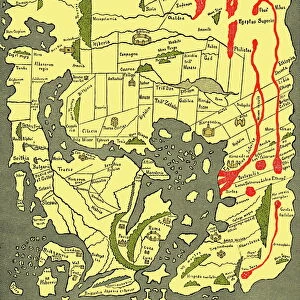
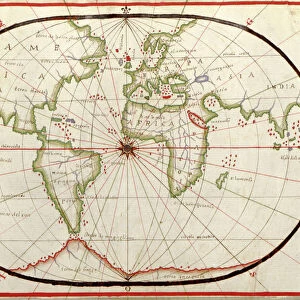
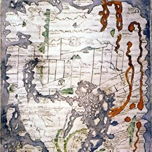
Metal Print : WORLD MAP 2ND CENTURY. World map according to Roman geographers of the 2nd century A. D


![]()
Metal Prints from Granger
WORLD MAP 2ND CENTURY. World map according to Roman geographers of the 2nd century A. D
WORLD MAP 2ND CENTURY. World map according to Roman geographers of the 2nd century A.D
Granger holds millions of images spanning more than 25,000 years of world history, from before the Stone Age to the dawn of the Space Age
Media ID 6622317
16"x24" (61x41cm) Metal Print
Step back in time with our stunning Metal Print of the World Map from the 2nd century A.D. This captivating piece, sourced from The Granger Collection at Granger Art on Demand, offers a unique glimpse into ancient Roman geography. The intricate details of this world map, created by Roman geographers over 1,800 years ago, are beautifully preserved in this high-quality Metal Print. Add an element of history and culture to your space with this captivating and conversation-starting artwork.
Made with durable metal and luxurious printing techniques, our metal photo prints go beyond traditional canvases, adding a cool, modern touch to your space. Wall mount on back. Eco-friendly 100% post-consumer recycled ChromaLuxe aluminum surface. The thickness of the print is 0.045". Featuring a Scratch-resistant surface and Rounded corners. Backing hangers are attached to the back of the print and float the print 1/2-inch off the wall when hung, the choice of hanger may vary depending on size and International orders will come with Float Mount hangers only. Finished with a brilliant white high gloss surface for unsurpassed detail and vibrance. Printed using Dye-Sublimation and for best care we recommend a non-ammonia glass cleaner, water, or isopropyl (rubbing) alcohol to prevent harming the print surface. We recommend using a clean, lint-free cloth to wipe off the print. The ultra-hard surface is scratch-resistant, waterproof and weatherproof. Avoid direct sunlight exposure.
Made with durable metal and luxurious printing techniques, metal prints bring images to life and add a modern touch to any space
Estimated Product Size is 61.5cm x 41.2cm (24.2" x 16.2")
These are individually made so all sizes are approximate
Artwork printed orientated as per the preview above, with landscape (horizontal) orientation to match the source image.
FEATURES IN THESE COLLECTIONS
> Granger Art on Demand
> Maps
> Arts
> Artists
> R
> Roman Roman
> Arts
> Landscape paintings
> Waterfall and river artworks
> River artworks
> Maps and Charts
> Related Images
> Maps and Charts
> World
EDITORS COMMENTS
This print titled "WORLD MAP 2ND CENTURY" takes us back in time to the era of Roman geographers in the 2nd century A. D. The image showcases a world map meticulously crafted by these ancient scholars, offering a glimpse into their understanding of the globe during that period. The map itself is an intriguing blend of accuracy and speculation, reflecting the knowledge and limitations of its creators. It depicts various continents, regions, and rivers known to them at the time. As we explore this historical artifact, we can almost imagine how Roman explorers would have navigated through vast oceans or traversed mighty rivers on their quests for conquest or trade. What makes this particular print from Granger Art on Demand even more fascinating is its attention to detail and authenticity. Every line drawn with precision tells a story about how our ancestors perceived their place in the world centuries ago. It serves as a reminder that human curiosity has always driven us to explore beyond our immediate surroundings. Whether you are an avid history enthusiast or simply appreciate art that transports you through time, this print will undoubtedly captivate your imagination. Display it proudly on your wall as a testament to humanity's enduring quest for knowledge and exploration throughout different eras.
MADE IN THE USA
Safe Shipping with 30 Day Money Back Guarantee
FREE PERSONALISATION*
We are proud to offer a range of customisation features including Personalised Captions, Color Filters and Picture Zoom Tools
SECURE PAYMENTS
We happily accept a wide range of payment options so you can pay for the things you need in the way that is most convenient for you
* Options may vary by product and licensing agreement. Zoomed Pictures can be adjusted in the Cart.