Metal Print > Arts > Landscape paintings > Waterfall and river artworks > River artworks
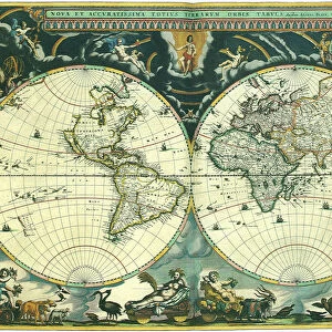
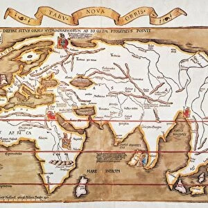
Metal Print : WORLD MAP, c1300. Map, late 19th century, depicting the extent of knowledge of the worlds geography c1300, and including the route of Marco Polos return voyage from China


![]()
Metal Prints from Granger
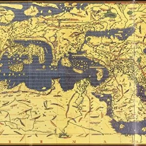
WORLD MAP, c1300. Map, late 19th century, depicting the extent of knowledge of the worlds geography c1300, and including the route of Marco Polos return voyage from China
WORLD MAP, c1300. Map, late 19th century, depicting the extent of knowledge of the worlds geography c1300, and including the route of Marco Polos return voyage from China in 1292
Granger holds millions of images spanning more than 25,000 years of world history, from before the Stone Age to the dawn of the Space Age
Media ID 6616407
1300 Exploration Mappa Mundi Mark Polo World
16"x24" (61x41cm) Metal Print
Step back in time with our stunning Media Storehouse Metal Print of a World Map from the late 19th century. This captivating map takes you back to the year 1300, showcasing the world's geographical knowledge during that era. A true testament to human curiosity and exploration, this map includes the remarkable route of Marco Polo's return voyage from China in 1292. Bring history to life in your home or office with this intricately detailed and beautifully preserved piece from The Granger Collection. Order your Metal Print today and let the adventure begin!
Made with durable metal and luxurious printing techniques, our metal photo prints go beyond traditional canvases, adding a cool, modern touch to your space. Wall mount on back. Eco-friendly 100% post-consumer recycled ChromaLuxe aluminum surface. The thickness of the print is 0.045". Featuring a Scratch-resistant surface and Rounded corners. Backing hangers are attached to the back of the print and float the print 1/2-inch off the wall when hung, the choice of hanger may vary depending on size and International orders will come with Float Mount hangers only. Finished with a brilliant white high gloss surface for unsurpassed detail and vibrance. Printed using Dye-Sublimation and for best care we recommend a non-ammonia glass cleaner, water, or isopropyl (rubbing) alcohol to prevent harming the print surface. We recommend using a clean, lint-free cloth to wipe off the print. The ultra-hard surface is scratch-resistant, waterproof and weatherproof. Avoid direct sunlight exposure.
Made with durable metal and luxurious printing techniques, metal prints bring images to life and add a modern touch to any space
Estimated Product Size is 61.5cm x 41.2cm (24.2" x 16.2")
These are individually made so all sizes are approximate
Artwork printed orientated as per the preview above, with landscape (horizontal) orientation to match the source image.
FEATURES IN THESE COLLECTIONS
> Granger Art on Demand
> Maps
> Arts
> Art Movements
> Medieval Art
> Arts
> Landscape paintings
> Waterfall and river artworks
> River artworks
> Maps and Charts
> Related Images
> Maps and Charts
> World
EDITORS COMMENTS
This print showcases a remarkable piece of history - the "WORLD MAP, c1300". Created in the late 19th century, this map depicts the extent of knowledge regarding global geography during the 14th century. It offers a fascinating glimpse into how people perceived and understood the world at that time. The map not only displays various continents and countries but also highlights significant exploration journeys undertaken during this period. One notable route depicted is that of Marco Polo's return voyage from China in 1292. This adds an exciting dimension to the artwork as it represents one of history's most renowned explorers and his incredible adventures. As we delve into this medieval treasure trove, we are transported back to a time when cartography was still evolving. The intricate details and delicate craftsmanship on display demonstrate both artistic skill and scientific curiosity prevalent during this era. The inclusion of rivers throughout the map further emphasizes its significance as waterways played a vital role in trade routes, transportation, and communication networks during medieval times. Overall, this stunning print from The Granger Collection serves as a visual testament to humanity's thirst for knowledge and exploration. It invites us to reflect on our ancestors' efforts to understand their place in an ever-expanding world while reminding us of our own ongoing journey towards discovery and understanding.
MADE IN THE USA
Safe Shipping with 30 Day Money Back Guarantee
FREE PERSONALISATION*
We are proud to offer a range of customisation features including Personalised Captions, Color Filters and Picture Zoom Tools
SECURE PAYMENTS
We happily accept a wide range of payment options so you can pay for the things you need in the way that is most convenient for you
* Options may vary by product and licensing agreement. Zoomed Pictures can be adjusted in the Cart.