Metal Print > Arts > Artists > W > Robert Walker
Metal Print : Map of the Battle of Le Mans, 11 January 1871, (c1872). Creator: R. Walker
. Creator: R. Walker")

![]()
Metal Prints from Heritage Images
Map of the Battle of Le Mans, 11 January 1871, (c1872). Creator: R. Walker
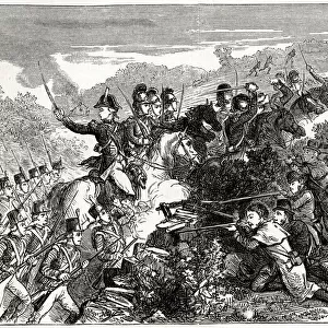
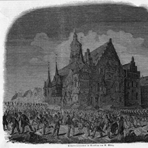
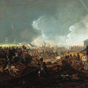
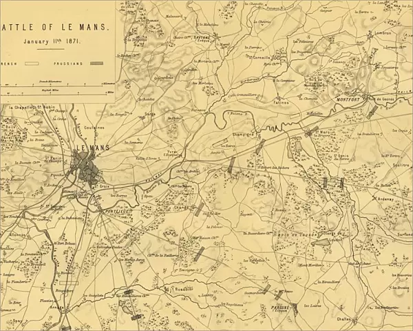
Map of the Battle of Le Mans, 11 January 1871, (c1872). Map: Drawn under the Superintendence of Captain Hozier, showing the enemy positions. The Battle of Le Mans, fought in northern France, was a decisive victory for the Germans and ended French resistance. From " The Franco-Prussian War: its causes, incidents and consequences", Volume II, by Captain H M Hozier. [William Mackenzie, London, 1872]
Heritage Images features heritage image collections
Media ID 19778729
© The Print Collector/Heritage Images
1870 1871 Adversary Bamp W Enemy Franco Prussian War Front Line Frontline H M Hozier Henry Montague Henry Montague Hozier Hozier Le Mans Lines Mackenzie Prussia Prussian Prussian Army R Walker Robert Walker Sarthe Sir Henry Montagu Hozier Walker William Mackenzie Battlefield
16"x20" (51x41cm) Metal Print
Step back in time with our vintage Map of the Battle of Le Mans, 11 January 1871, from the Media Storehouse Metal Prints collection. This intricately detailed map, created by R. Walker around 1872, was drawn under the superintendence of Captain Hozier and shows the enemy positions. Bring history into your home or office with this unique and captivating piece. Our high-quality Metal Prints are waterproof, scratch-resistant, and UV protected, ensuring your investment is long-lasting. Add this historical map to your decor and start a conversation about the rich history of the Battle of Le Mans.
Made with durable metal and luxurious printing techniques, our metal photo prints go beyond traditional canvases, adding a cool, modern touch to your space. Wall mount on back. Eco-friendly 100% post-consumer recycled ChromaLuxe aluminum surface. The thickness of the print is 0.045". Featuring a Scratch-resistant surface and Rounded corners. Backing hangers are attached to the back of the print and float the print 1/2-inch off the wall when hung, the choice of hanger may vary depending on size and International orders will come with Float Mount hangers only. Finished with a brilliant white high gloss surface for unsurpassed detail and vibrance. Printed using Dye-Sublimation and for best care we recommend a non-ammonia glass cleaner, water, or isopropyl (rubbing) alcohol to prevent harming the print surface. We recommend using a clean, lint-free cloth to wipe off the print. The ultra-hard surface is scratch-resistant, waterproof and weatherproof. Avoid direct sunlight exposure.
Made with durable metal and luxurious printing techniques, metal prints bring images to life and add a modern touch to any space
Estimated Image Size (if not cropped) is 50.8cm x 40.6cm (20" x 16")
Estimated Product Size is 51.4cm x 41.2cm (20.2" x 16.2")
These are individually made so all sizes are approximate
Artwork printed orientated as per the preview above, with landscape (horizontal) orientation to match the source image.
FEATURES IN THESE COLLECTIONS
> Arts
> Artists
> W
> Robert Walker
> Arts
> Artists
> W
> Robert White
> Arts
> Artists
> W
> William White
> Arts
> Landscape paintings
> Waterfall and river artworks
> River artworks
> Europe
> France
> Canton
> Sarthe
> Historic
> Battles
> Related Images
EDITORS COMMENTS
This print showcases the "Map of the Battle of Le Mans, 11 January 1871". Created by R. Walker and drawn under the superintendence of Captain Hozier, this map provides a detailed depiction of enemy positions during this significant battle fought in northern France. The Battle of Le Mans marked a decisive victory for the Germans, ultimately bringing an end to French resistance. As we observe this historical map, we can't help but be transported back to that tumultuous time in history when armed forces clashed on these very grounds. The intricate lines and geographical features depicted on this map serve as a testament to the strategic planning and execution required during warfare in the 19th century. The battlefield itself is etched with intensity, representing both adversary positions and potential areas for advancement. Through this print, we gain insight into not only the physical layout of the battlefield but also into the minds behind military operations. Captain Hozier's meticulous supervision ensures that every detail is accurately represented. As we delve deeper into "The Franco-Prussian War: its causes, incidents and consequences". Volume II by Captain H M Hozier, published by William Mackenzie in London in 1872, we uncover valuable insights about one of history's most significant conflicts – The Franco-Prussian War.
MADE IN THE USA
Safe Shipping with 30 Day Money Back Guarantee
FREE PERSONALISATION*
We are proud to offer a range of customisation features including Personalised Captions, Color Filters and Picture Zoom Tools
SECURE PAYMENTS
We happily accept a wide range of payment options so you can pay for the things you need in the way that is most convenient for you
* Options may vary by product and licensing agreement. Zoomed Pictures can be adjusted in the Cart.