Metal Print > Arts > Artists > W > Robert Walker
Metal Print : Map of the Battle of Sedan, 1 September 1870, (c1872). Creator: R. Walker
. Creator: R. Walker")


![]()
Metal Prints from Heritage Images
Map of the Battle of Sedan, 1 September 1870, (c1872). Creator: R. Walker
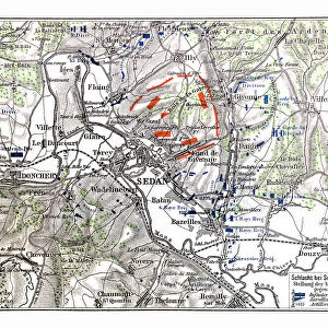
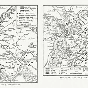
Map of the Battle of Sedan, 1 September 1870, (c1872). Map: Drawn under the Superintendance of Captain Hozier, showing the enemy positions. The Battle of Sedan was a national humiliation for the French, as their army was decisively defeated by the Prussians commanded by Moltke, and the Emperor Napoleon III captured. The defeat led to the fall of the French Second Empire and the occupation of Paris by the Germans and, in 1871, the creation of the German Empire. From " The Franco-Prussian War: its causes, incidents and consequences", Volume I, by Captain H M Hozier. [William Mackenzie, London, 1872]
Heritage Images features heritage image collections
Media ID 19778677
© The Print Collector/Heritage Images
1870 1871 Adversary Bamp W Battle Of Sedan Border Enemy Franco Prussian War Front Line Frontier Frontline H M Hozier Henry Montague Henry Montague Hozier Hozier Lines Mackenzie Prussia Prussian Prussian Army R Walker Robert Walker Sedan Sir Henry Montagu Hozier Walker William Mackenzie Battlefield
16"x24" (61x41cm) Metal Print
Step back in time with our stunning Metal Print of the Battle of Sedan Map (c1872), an intriguing piece of historical cartography. This detailed and captivating map, created by R. Walker under the supervision of Captain Hozier, depicts the strategic positions of the opposing forces during the Battle of Sedan on 1 September 1870. Each Metal Print is meticulously crafted, providing a unique and vibrant display of history. Bring this piece of the past into your home or office and start fascinating conversations with its intriguing details. Order your Metal Print of the Battle of Sedan Map today and add a touch of history to your space.
Made with durable metal and luxurious printing techniques, our metal photo prints go beyond traditional canvases, adding a cool, modern touch to your space. Wall mount on back. Eco-friendly 100% post-consumer recycled ChromaLuxe aluminum surface. The thickness of the print is 0.045". Featuring a Scratch-resistant surface and Rounded corners. Backing hangers are attached to the back of the print and float the print 1/2-inch off the wall when hung, the choice of hanger may vary depending on size and International orders will come with Float Mount hangers only. Finished with a brilliant white high gloss surface for unsurpassed detail and vibrance. Printed using Dye-Sublimation and for best care we recommend a non-ammonia glass cleaner, water, or isopropyl (rubbing) alcohol to prevent harming the print surface. We recommend using a clean, lint-free cloth to wipe off the print. The ultra-hard surface is scratch-resistant, waterproof and weatherproof. Avoid direct sunlight exposure.
Made with durable metal and luxurious printing techniques, metal prints bring images to life and add a modern touch to any space
Estimated Product Size is 61.5cm x 41.2cm (24.2" x 16.2")
These are individually made so all sizes are approximate
Artwork printed orientated as per the preview above, with landscape (horizontal) orientation to match the source image.
FEATURES IN THESE COLLECTIONS
> Arts
> Artists
> W
> Robert Walker
> Arts
> Artists
> W
> Robert White
> Arts
> Artists
> W
> William White
> Arts
> Landscape paintings
> Forest and woodland scenes
> Forest artwork
> Arts
> Landscape paintings
> Waterfall and river artworks
> River artworks
> Europe
> France
> Paris
> Maps
> Europe
> France
> Paris
> Related Images
> Historic
> Battles
> Related Images
EDITORS COMMENTS
This print showcases a historical map of the Battle of Sedan, which took place on 1 September 1870. Created by R. Walker and drawn under the supervision of Captain Hozier, this map provides a detailed depiction of enemy positions during the battle. The Battle of Sedan was a significant event in French history as it resulted in a decisive defeat for the French army at the hands of Prussian forces led by Moltke. This defeat not only brought national humiliation to France but also led to the fall of the French Second Empire and subsequent occupation of Paris by German forces. The map captures the geographical features surrounding Sedan, including forests, rivers, and country borders. It serves as a visual representation of warfare strategies employed during this 19th-century conflict between France and Prussia. This historic print is part of "The Franco-Prussian War: its causes, incidents and consequences". Volume I by Captain H. M. Hozier published in London in 1872 by William Mackenzie. The creator Robert Walker has skillfully illustrated both sides' front lines with precision while highlighting key locations relevant to understanding this pivotal battle. As an important artifact from one of Europe's defining conflicts, this print offers viewers an opportunity to delve into military history while reflecting upon its far-reaching consequences on nations involved in war during that era.
MADE IN THE USA
Safe Shipping with 30 Day Money Back Guarantee
FREE PERSONALISATION*
We are proud to offer a range of customisation features including Personalised Captions, Color Filters and Picture Zoom Tools
SECURE PAYMENTS
We happily accept a wide range of payment options so you can pay for the things you need in the way that is most convenient for you
* Options may vary by product and licensing agreement. Zoomed Pictures can be adjusted in the Cart.