Metal Print > North America > Martinique > Maps
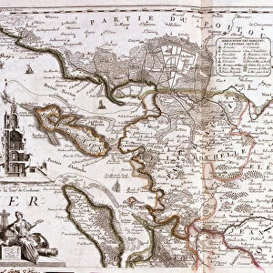
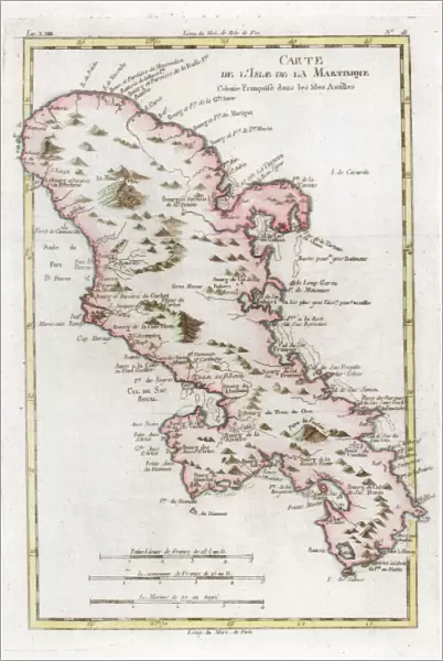
Metal Print : Map of the Caribbean island of Martinique, c1783

![]()
Metal Prints from Heritage Images
Map of the Caribbean island of Martinique, c1783
Heritage Images features heritage image collections
Media ID 14953530
© The Print Collector / Heritage-Images
Caribbean Cartography Colony Indies Island Map Making Martinique Print Collector21 Topographical Topography West Indian West Indies
16"x24" (61x41cm) Metal Print
Discover the rich history of the Caribbean with our stunning Metal Prints featuring a captivating Map of Martinique from 1783. This vintage map, sourced from Heritage Images, showcases the intricate details of the island's geography during an era of exploration and discovery. Bring the allure of the Caribbean into your home or office with this unique and eye-catching decor piece. Our high-quality Metal Prints are waterproof, scratch-resistant, and UV-protected, ensuring your investment remains vibrant and beautiful for years to come.
Made with durable metal and luxurious printing techniques, our metal photo prints go beyond traditional canvases, adding a cool, modern touch to your space. Wall mount on back. Eco-friendly 100% post-consumer recycled ChromaLuxe aluminum surface. The thickness of the print is 0.045". Featuring a Scratch-resistant surface and Rounded corners. Backing hangers are attached to the back of the print and float the print 1/2-inch off the wall when hung, the choice of hanger may vary depending on size and International orders will come with Float Mount hangers only. Finished with a brilliant white high gloss surface for unsurpassed detail and vibrance. Printed using Dye-Sublimation and for best care we recommend a non-ammonia glass cleaner, water, or isopropyl (rubbing) alcohol to prevent harming the print surface. We recommend using a clean, lint-free cloth to wipe off the print. The ultra-hard surface is scratch-resistant, waterproof and weatherproof. Avoid direct sunlight exposure.
Made with durable metal and luxurious printing techniques, metal prints bring images to life and add a modern touch to any space
Estimated Product Size is 41.2cm x 61.5cm (16.2" x 24.2")
These are individually made so all sizes are approximate
Artwork printed orientated as per the preview above, with portrait (vertical) orientation to match the source image.
FEATURES IN THESE COLLECTIONS
> Maps and Charts
> Related Images
> North America
> Martinique
> Maps
> North America
> Martinique
> Related Images
EDITORS COMMENTS
This print showcases a beautifully detailed map of the Caribbean island of Martinique, dating back to the late 18th century. Created by an unknown cartographer, this exquisite engraving offers a glimpse into the colonial era and highlights the French influence on this vibrant island. The map is adorned with vivid colors that bring to life the topography and geographical features of Martinique. From its stunning coastline that stretches along the azure waters of the Caribbean Sea to its lush interior dotted with mountains and valleys, every detail has been meticulously captured. As one explores this historic map, it becomes evident how important Martinique was as a strategic location in the West Indies during this period. Its position within the region made it a valuable colony for France, serving as a hub for trade and commerce between Europe and its colonies in America. The craftsmanship displayed in this print reflects both artistic skill and scientific precision. Map making was not only an art form but also an essential tool for exploration and navigation during these times. Today, this remarkable piece serves as a testament to our fascination with history and geography. It allows us to appreciate how far we have come while reminding us of our interconnectedness across time and space.
MADE IN THE USA
Safe Shipping with 30 Day Money Back Guarantee
FREE PERSONALISATION*
We are proud to offer a range of customisation features including Personalised Captions, Color Filters and Picture Zoom Tools
SECURE PAYMENTS
We happily accept a wide range of payment options so you can pay for the things you need in the way that is most convenient for you
* Options may vary by product and licensing agreement. Zoomed Pictures can be adjusted in the Cart.