Metal Print > Europe > United Kingdom > England > London > Sights > London Eye
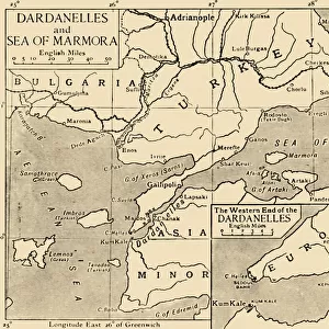
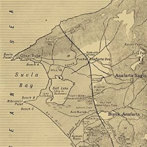
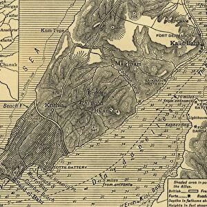
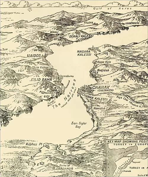
Metal Print : Map of the Dardanelles, First World War, 1915, (c1920). Creator: Unknown
. Creator: Unknown")
![]()
Metal Prints from Heritage Images
Map of the Dardanelles, First World War, 1915, (c1920). Creator: Unknown
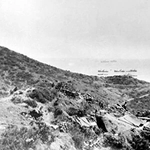
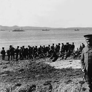
Map of the Dardanelles, First World War, 1915, (c1920). Bird s-eye View of the Dardanelles from the Entrance to the Straits to the Narrows. From " The Great World War - A History" Volume III, edited by Frank A Mumby. [The Gresham Publishing Company Ltd, London, c1920]
Heritage Images features heritage image collections
Media ID 19175361
© The Print Collector/Heritage Images
Aerial View Dardanelles Dardanelles Campaign Frank Arthur Frank Arthur Mumby George Philip And Son George Philip And Son Ltd Gresham Publishing Co Ltd Gresham Publishing Company Hellespont Keystone Archives London Geographical Institute Mumby Mumby Frank Arthur Philip Strait The Great World War A History Theatre Of War Turkey
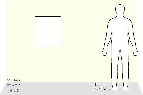
20"x24" (61x51cm) Metal Print
Step back in time with our vintage Map of the Dardanelles Metal Print from Media Storehouse. This captivating image, originally from Heritage Images, dates back to the First World War era, around 1920. The bird's-eye view of the Dardanelles Straits, from the entrance to the narrows, offers a unique perspective of this historically significant region. The intricate details of the map are beautifully preserved in this metal print, making it a perfect addition to any history or military-themed decor. Relive the past with this stunning, unknown creator's work and bring a piece of history into your home or office.
Made with durable metal and luxurious printing techniques, our metal photo prints go beyond traditional canvases, adding a cool, modern touch to your space. Wall mount on back. Eco-friendly 100% post-consumer recycled ChromaLuxe aluminum surface. The thickness of the print is 0.045". Featuring a Scratch-resistant surface and Rounded corners. Backing hangers are attached to the back of the print and float the print 1/2-inch off the wall when hung, the choice of hanger may vary depending on size and International orders will come with Float Mount hangers only. Finished with a brilliant white high gloss surface for unsurpassed detail and vibrance. Printed using Dye-Sublimation and for best care we recommend a non-ammonia glass cleaner, water, or isopropyl (rubbing) alcohol to prevent harming the print surface. We recommend using a clean, lint-free cloth to wipe off the print. The ultra-hard surface is scratch-resistant, waterproof and weatherproof. Avoid direct sunlight exposure.
Made with durable metal and luxurious printing techniques, metal prints bring images to life and add a modern touch to any space
Estimated Image Size (if not cropped) is 50.8cm x 60.9cm (20" x 24")
Estimated Product Size is 51.4cm x 61.5cm (20.2" x 24.2")
These are individually made so all sizes are approximate
Artwork printed orientated as per the preview above, with portrait (vertical) orientation to match the source image.
FEATURES IN THESE COLLECTIONS
> Aerial Photography
> Related Images
> Asia
> Turkey
> Related Images
> Europe
> United Kingdom
> England
> London
> Art
> Theatre
> Europe
> United Kingdom
> England
> London
> Sights
> London Eye
> Historic
> World War I and II
> World War I
> Historic
> World War I and II
> Maps and Charts
> Related Images
> Maps and Charts
> World
EDITORS COMMENTS
This print showcases a historically significant map of the Dardanelles during the First World War. Taken from "The Great World War - A History". Volume III, edited by Frank A Mumby, this aerial view provides a bird's-eye perspective of the strategic region. The Dardanelles campaign was a crucial theater of war in which various nations fought for control over this narrow strait connecting the Aegean Sea to the Sea of Marmara. The creator of this remarkable piece remains unknown, but their attention to detail is evident as they depict not only the geographical features but also the mountains surrounding this vital waterway. Published around 1920 by The Gresham Publishing Company Ltd in London, it serves as an invaluable historical artifact that sheds light on one of the most significant conflicts in modern history. With its intricate depiction and accurate representation, this map offers viewers a glimpse into an era defined by turmoil and conflict. It stands as a testament to human resilience and determination during times of war. Whether you are an avid historian or simply intrigued by world events, this print transports you back to a pivotal moment in time when nations clashed for supremacy amidst breathtaking natural landscapes.
MADE IN THE USA
Safe Shipping with 30 Day Money Back Guarantee
FREE PERSONALISATION*
We are proud to offer a range of customisation features including Personalised Captions, Color Filters and Picture Zoom Tools
SECURE PAYMENTS
We happily accept a wide range of payment options so you can pay for the things you need in the way that is most convenient for you
* Options may vary by product and licensing agreement. Zoomed Pictures can be adjusted in the Cart.