Metal Print > Arts > Artists > C > William Caxton
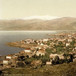
Metal Print : Map To Illustrate The Campaign in Palestine, 1919. Creator: London Geographical Institute


![]()
Metal Prints from Heritage Images
Map To Illustrate The Campaign in Palestine, 1919. Creator: London Geographical Institute
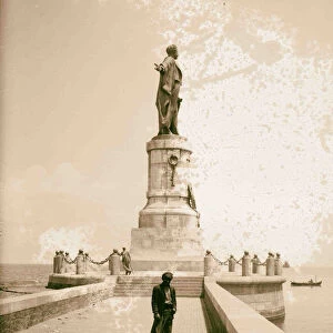
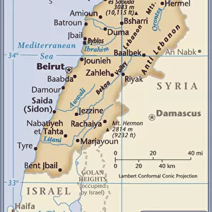
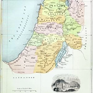
Map To Illustrate The Campaign in Palestine, 1919. Map of the Eastern Mediterrean and the Middle East, showing Cyprus, Port Said in Egypt, parts of Turkey and what are now Syria, the Lebanon, Israel and the Occupied Territories including Gaza. From " The History of the Great European War: its causes and effects", Vol. IX, by W. Stanley Macbean Knight. [Caxton Pulishing Company, Limited, London, 1919]
Heritage Images features heritage image collections
Media ID 19047561
© The Print Collector/Heritage Images
Beirut Bur Said Campaign Caxton Publishing Company Caxton Pulishing Company Caxton Pulishing Company Lim Caxton Pulishing Company Limited Caxton Pulishing Company Ltd Cyprus Israel Knight Lebanon Limited London Geographical Institute Mediterranean Palestine Port Said Stanley Macbean Stanley Macbean Knight Syria Turkey W Stanley Macbean W Stanley Macbean Knight William Stanley Macbean William Stanley Macbean Knight Gaza
16"x24" (61x41cm) Metal Print
Discover history through the lens of a bygone era with Media Storehouse's Metal Prints featuring the "Map to Illustrate The Campaign in Palestine, 1919" from Heritage Images. This captivating vintage map, created by the London Geographical Institute, offers a unique perspective on the Eastern Mediterranean and the Middle East during a pivotal moment in history. Depicting Cyprus, Port Said in Egypt, parts of Turkey, and what are now Syria and Lebanon, this intricately detailed map is a must-have for history enthusiasts, geography buffs, and anyone seeking to add a touch of nostalgia to their space. Our high-quality Metal Prints bring out the rich colors and intricate details of this historical map, making it a stunning addition to any room. Order yours today and let this piece of history tell its story in your home or office.
Made with durable metal and luxurious printing techniques, our metal photo prints go beyond traditional canvases, adding a cool, modern touch to your space. Wall mount on back. Eco-friendly 100% post-consumer recycled ChromaLuxe aluminum surface. The thickness of the print is 0.045". Featuring a Scratch-resistant surface and Rounded corners. Backing hangers are attached to the back of the print and float the print 1/2-inch off the wall when hung, the choice of hanger may vary depending on size and International orders will come with Float Mount hangers only. Finished with a brilliant white high gloss surface for unsurpassed detail and vibrance. Printed using Dye-Sublimation and for best care we recommend a non-ammonia glass cleaner, water, or isopropyl (rubbing) alcohol to prevent harming the print surface. We recommend using a clean, lint-free cloth to wipe off the print. The ultra-hard surface is scratch-resistant, waterproof and weatherproof. Avoid direct sunlight exposure.
Made with durable metal and luxurious printing techniques, metal prints bring images to life and add a modern touch to any space
Estimated Product Size is 41.2cm x 61.5cm (16.2" x 24.2")
These are individually made so all sizes are approximate
Artwork printed orientated as per the preview above, with portrait (vertical) orientation to match the source image.
FEATURES IN THESE COLLECTIONS
> Africa
> Egypt
> Related Images
> Arts
> Artists
> C
> William Caxton
> Arts
> Artists
> S
> Syrian Syrian
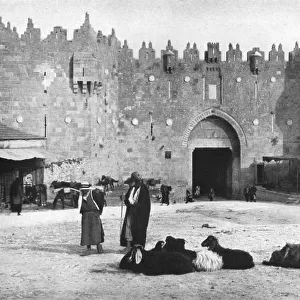
> Asia
> Cyprus
> Related Images
> Asia
> Israel
> Related Images
EDITORS COMMENTS
This print showcases a historic map titled "Map To Illustrate The Campaign in Palestine, 1919". Created by the esteemed London Geographical Institute, this detailed map takes us back to the early 20th century during World War I. It depicts the Eastern Mediterranean and Middle East regions, featuring significant locations such as Cyprus, Port Said in Egypt, parts of Turkey, Syria, Lebanon, Israel, and the Occupied Territories including Gaza. Originally published in "The History of the Great European War: its causes and effects". Volume IX by W. Stanley Macbean Knight in 1919 under Caxton Publishing Company Limited in London. This remarkable piece offers valuable insights into the geographical features and strategic importance of these areas during that time. With vibrant colors highlighting coastlines and urban centers like Beirut in Lebanon and Bur Said in Egypt along with sea routes connecting various territories across the Mediterranean Sea, this map serves as a visual representation of an era marked by conflict and transformation. As we delve into this historical artifact captured by The Print Collector from Heritage Images collection, we are transported to a pivotal moment where world powers were vying for control over these lands amidst the chaos of war. It stands as a testament to human endeavors to understand our surroundings while shedding light on how past events have shaped our present reality.
MADE IN THE USA
Safe Shipping with 30 Day Money Back Guarantee
FREE PERSONALISATION*
We are proud to offer a range of customisation features including Personalised Captions, Color Filters and Picture Zoom Tools
SECURE PAYMENTS
We happily accept a wide range of payment options so you can pay for the things you need in the way that is most convenient for you
* Options may vary by product and licensing agreement. Zoomed Pictures can be adjusted in the Cart.