Metal Print > Europe > United Kingdom > England > London > Art > Theatre
Metal Print : Map illustrating the Operations of the First Army... First World War, 1915, (c1920)
")


![]()
Metal Prints from Heritage Images
Map illustrating the Operations of the First Army... First World War, 1915, (c1920)
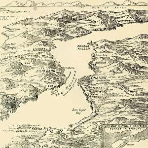
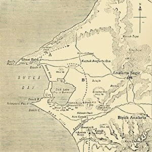
Map illustrating the Operations of the First Army, under Sir Douglas Haig, during May and June, 1915, First World War, (c1920). Part of northern France showing British positions near the town of Neuve-Chapelle. From " The Great World War - A History" Volume III, edited by Frank A Mumby. [The Gresham Publishing Company Ltd, London, c1920]
Heritage Images features heritage image collections
Media ID 19175529
© The Print Collector/Heritage Images
1st Earl Haig A History Butcher Haig Douglas Haig Douglas Haig 1st Earl Haig Earl Haig Field Marshal Sir Douglas Haig Field Marshall Douglas Haig Frank Arthur Frank Arthur Mumby Front Line Frontline Gresham Publishing Co Ltd Gresham Publishing Company Haig Haig Douglas Haig Sir Douglas Keystone Archives Mumby Mumby Frank Arthur Neuve Chapelle Nord Pas De Calais Pas De Calais Position Positions Sir Douglas Sir Douglas Haig The Great World War The Great World War A History Theatre Of War Battlefield
16"x20" (51x41cm) Metal Print
Step back in time with our exclusive Media Storehouse Metal Print featuring a historic map illustrating the Operations of the First Army during May and June 1915, from the First World War. This captivating vintage map, dated circa 1920, showcases the strategic movements of Sir Douglas Haig's First Army, bringing a piece of military history into your home or office. The high-quality metal print not only preserves the intricate details of this rare map but also adds a distinctive, modern twist with its vibrant colors and sleek finish. Elevate your space with this unique and educational piece of art that tells the story of a pivotal moment in world history. From Heritage Images, this is more than just a print – it's a window into the past.
Made with durable metal and luxurious printing techniques, our metal photo prints go beyond traditional canvases, adding a cool, modern touch to your space. Wall mount on back. Eco-friendly 100% post-consumer recycled ChromaLuxe aluminum surface. The thickness of the print is 0.045". Featuring a Scratch-resistant surface and Rounded corners. Backing hangers are attached to the back of the print and float the print 1/2-inch off the wall when hung, the choice of hanger may vary depending on size and International orders will come with Float Mount hangers only. Finished with a brilliant white high gloss surface for unsurpassed detail and vibrance. Printed using Dye-Sublimation and for best care we recommend a non-ammonia glass cleaner, water, or isopropyl (rubbing) alcohol to prevent harming the print surface. We recommend using a clean, lint-free cloth to wipe off the print. The ultra-hard surface is scratch-resistant, waterproof and weatherproof. Avoid direct sunlight exposure.
Made with durable metal and luxurious printing techniques, metal prints bring images to life and add a modern touch to any space
Estimated Image Size (if not cropped) is 40.6cm x 50.8cm (16" x 20")
Estimated Product Size is 41.2cm x 51.4cm (16.2" x 20.2")
These are individually made so all sizes are approximate
Artwork printed orientated as per the preview above, with portrait (vertical) orientation to match the source image.
FEATURES IN THESE COLLECTIONS
> Europe
> France
> Canton
> Nord
> Europe
> France
> Canton
> Pas de Calais
> Europe
> United Kingdom
> England
> London
> Art
> Theatre
> Historic
> World War I and II
> Battlefields
> Historic
> World War I and II
> World War I
> Historic
> World War I and II
EDITORS COMMENTS
This print showcases a historic map titled "Map illustrating the Operations of the First Army, under Sir Douglas Haig, during May and June 1915" from the First World War. The image is taken from the book "The Great World War - A History" edited by Frank A Mumby and published by The Gresham Publishing Company Ltd in London around 1920. The map provides a detailed overview of northern France, specifically highlighting British positions near the town of Neuve-Chapelle. It offers a glimpse into one of the significant battlegrounds where brave soldiers fought for their nations during this tumultuous period in history. Sir Douglas Haig, known as "Butcher Haig" to some due to his controversial decisions during the war, commanded the First Army depicted on this map. He played a crucial role in shaping military strategies and leading troops through treacherous conditions. The print captures not only an important historical document but also serves as a visual representation of warfare tactics employed during that time. It symbolizes both triumphs and tragedies experienced by those who served on these frontlines. With its intricate details and evocative nature, this photograph invites viewers to reflect upon the sacrifices made by countless individuals amidst one of humanity's most devastating conflicts.
MADE IN THE USA
Safe Shipping with 30 Day Money Back Guarantee
FREE PERSONALISATION*
We are proud to offer a range of customisation features including Personalised Captions, Color Filters and Picture Zoom Tools
SECURE PAYMENTS
We happily accept a wide range of payment options so you can pay for the things you need in the way that is most convenient for you
* Options may vary by product and licensing agreement. Zoomed Pictures can be adjusted in the Cart.