Metal Print > Arts > Literature > Illustration
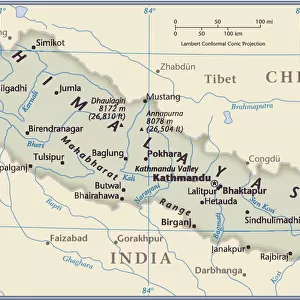
Metal Print : Map of Nepaul, c1891. Creator: James Grant


![]()
Metal Prints from Heritage Images
Map of Nepaul, c1891. Creator: James Grant
Map of Nepaul, c1891. From " Cassells Illustrated History of India Vol. I.", by James Grant. [Cassell Petter & Galpin, London, Paris and New York]
Heritage Images features heritage image collections
Media ID 25322560
© The Print Collector/Heritage Images
British India British Protectorate British Raj Cassell Petter Galpin Cassells Illustrated History Of India Galpin Grant James Himalayas Imperialism James Grant Mountain Range Nepal Petter And Petter And Galpin The Raj British Empire Cassell
16"x20" (51x41cm) Metal Print
Step back in time with our stunning Metal Print of a historical map of Nepal, created by James Grant in 1891. This intricately detailed map, originally published in "Cassell's Illustrated History of India," transports you to a bygone era. The vibrant colors and sharp lines of the map are beautifully preserved in our high-quality Metal Print, making it a captivating addition to any room. Bring history into your home with this unique and eye-catching piece of art.
Made with durable metal and luxurious printing techniques, our metal photo prints go beyond traditional canvases, adding a cool, modern touch to your space. Wall mount on back. Eco-friendly 100% post-consumer recycled ChromaLuxe aluminum surface. The thickness of the print is 0.045". Featuring a Scratch-resistant surface and Rounded corners. Backing hangers are attached to the back of the print and float the print 1/2-inch off the wall when hung, the choice of hanger may vary depending on size and International orders will come with Float Mount hangers only. Finished with a brilliant white high gloss surface for unsurpassed detail and vibrance. Printed using Dye-Sublimation and for best care we recommend a non-ammonia glass cleaner, water, or isopropyl (rubbing) alcohol to prevent harming the print surface. We recommend using a clean, lint-free cloth to wipe off the print. The ultra-hard surface is scratch-resistant, waterproof and weatherproof. Avoid direct sunlight exposure.
Made with durable metal and luxurious printing techniques, metal prints bring images to life and add a modern touch to any space
Estimated Image Size (if not cropped) is 50.8cm x 40.6cm (20" x 16")
Estimated Product Size is 51.4cm x 41.2cm (20.2" x 16.2")
These are individually made so all sizes are approximate
Artwork printed orientated as per the preview above, with landscape (horizontal) orientation to match the source image.
FEATURES IN THESE COLLECTIONS
> Arts
> Literature
> Illustration
> Asia
> India
> Related Images
> Asia
> Nepal
> Related Images
> Europe
> France
> Paris
> Maps
> Historic
> Colonial history
> Colonial art and artists
> Maps and Charts
> British Empire Maps
> Maps and Charts
> India
EDITORS COMMENTS
This print showcases a historical treasure - the "Map of Nepaul, c1891" created by James Grant. Taken from his renowned work "Cassells Illustrated History of India Vol. I. ", this map offers a fascinating glimpse into the rich heritage of British India during the 19th century. The intricate details on this close-up view allow us to explore the geography and geographical features of Nepal, nestled amidst the majestic Himalayas. As we trace our eyes along its contours, we are transported back in time to an era when colonialism and imperialism shaped the world. Grant's illustration skillfully captures not only the physical landscape but also reflects upon Nepal's significance as a British protectorate within their vast empire. The mountains that dominate this map serve as a reminder of both nature's beauty and challenges faced by those who traversed these lands. As we delve deeper into this piece, it becomes evident that it is more than just a map; it is an invaluable literary artifact that sheds light on history itself. Its inclusion in "Cassells Illustrated History of India" speaks volumes about its importance in documenting the British Raj and their influence over Asia. This print serves as a testament to James Grant's expertise as well as his contribution to literature and cartography during his time. Preserved with care by The Print Collector, it allows us to appreciate not only its artistic value but also provides valuable insights into our shared past.
MADE IN THE USA
Safe Shipping with 30 Day Money Back Guarantee
FREE PERSONALISATION*
We are proud to offer a range of customisation features including Personalised Captions, Color Filters and Picture Zoom Tools
SECURE PAYMENTS
We happily accept a wide range of payment options so you can pay for the things you need in the way that is most convenient for you
* Options may vary by product and licensing agreement. Zoomed Pictures can be adjusted in the Cart.