Metal Print > Arts > Artists > K > Athanasius Kircher
Metal Print : Use of the magnetic compass in map making, 1643


![]()
Metal Prints from Heritage Images
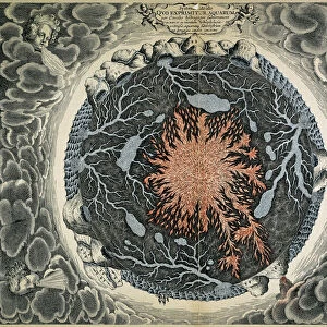
Use of the magnetic compass in map making, 1643
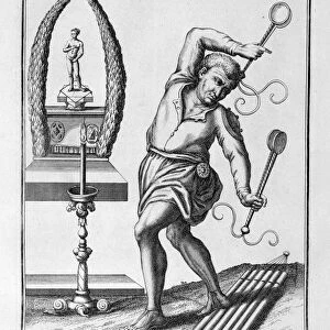
Use of the magnetic compass in map making, 1643. Diagram of the use of the compass by cartographers and surveyors. Bor (Borealis) is north and Aust (Australis) is south. From Magnes: sive de arte magnetica by Athanasius Kircher. (Rome, 1643)
Heritage Images features heritage image collections
Media ID 14865934
© Oxford Science Archive / Heritage-Images
Arithmetic Athanasius Athanasius Kircher Athanasius Kirchner Cartography Compass Innovation Kircher Kirchner Athanasius Magnetic Magnetism Map Making Mathematics Maths Navigation Navigational Device North Oxford Science Archive Physics South Surveying World
16"x20" (51x41cm) Metal Print
Discover the captivating allure of the past with our Media Storehouse Metal Print featuring the iconic diagram, "Use of the Magnetic Compass in Map Making," by Athanasius Kircher from Heritage Images. This intriguing 17th-century illustration showcases the essential role of the magnetic compass in cartography and surveying, with Bor (Borealis) representing the North and Aust (Australis) the South. Bring history to life in your home or office with this stunning, high-definition metal print. Its vibrant colors and exceptional detail are sure to captivate and inspire, making it a unique and thought-provoking addition to any space. Order yours today and let the story of map making unfold before your eyes.
Made with durable metal and luxurious printing techniques, our metal photo prints go beyond traditional canvases, adding a cool, modern touch to your space. Wall mount on back. Eco-friendly 100% post-consumer recycled ChromaLuxe aluminum surface. The thickness of the print is 0.045". Featuring a Scratch-resistant surface and Rounded corners. Backing hangers are attached to the back of the print and float the print 1/2-inch off the wall when hung, the choice of hanger may vary depending on size and International orders will come with Float Mount hangers only. Finished with a brilliant white high gloss surface for unsurpassed detail and vibrance. Printed using Dye-Sublimation and for best care we recommend a non-ammonia glass cleaner, water, or isopropyl (rubbing) alcohol to prevent harming the print surface. We recommend using a clean, lint-free cloth to wipe off the print. The ultra-hard surface is scratch-resistant, waterproof and weatherproof. Avoid direct sunlight exposure.
Made with durable metal and luxurious printing techniques, metal prints bring images to life and add a modern touch to any space
Estimated Image Size (if not cropped) is 40.6cm x 50.8cm (16" x 20")
Estimated Product Size is 41.2cm x 51.4cm (16.2" x 20.2")
These are individually made so all sizes are approximate
Artwork printed orientated as per the preview above, with portrait (vertical) orientation to match the source image.
FEATURES IN THESE COLLECTIONS
> Animals
> Mammals
> Cricetidae
> Australis
> Animals
> Mammals
> Delphinidae
> Australis
> Animals
> Mammals
> Molossidae
> Australis
> Arts
> Artists
> K
> Athanasius Kircher
> Europe
> Italy
> Lazio
> Rome
> Maps and Charts
> Related Images
> Maps and Charts
> World
EDITORS COMMENTS
This print takes us back to the 17th century, showcasing the use of a magnetic compass in map making. The diagram depicted here is from Athanasius Kircher's renowned work "Magnes: sive de arte magnetica" published in Rome in 1643. It beautifully illustrates how cartographers and surveyors utilized this navigational device to determine directions on maps. Intriguingly, the woodcut diagram reveals that Bor (Borealis) represents north, while Aust (Australis) signifies south. This simple yet groundbreaking concept revolutionized map making during this era. The image captures the essence of innovation and technology merging with traditional cartography techniques. Kircher's work not only showcases his expertise in mathematics but also highlights his deep understanding of magnetism and its application to navigation. His contributions to science and physics are evident through this remarkable piece of art. As we gaze upon this monochrome print, we are transported into a world where exploration was at its peak, and accurate mapping was crucial for navigation across vast territories. This photograph serves as a reminder of the significant advancements made during the seventeenth century in terms of geographical knowledge and scientific discoveries. Preserved by Oxford Science Archive, this print allows us to appreciate Athanasius Kircher's legacy as an influential figure in both cartography and scientific research.
MADE IN THE USA
Safe Shipping with 30 Day Money Back Guarantee
FREE PERSONALISATION*
We are proud to offer a range of customisation features including Personalised Captions, Color Filters and Picture Zoom Tools
FREE COLORIZATION SERVICE
You can choose advanced AI Colorization for this picture at no extra charge!
SECURE PAYMENTS
We happily accept a wide range of payment options so you can pay for the things you need in the way that is most convenient for you
* Options may vary by product and licensing agreement. Zoomed Pictures can be adjusted in the Cart.