Metal Print > Europe > United Kingdom > Scotland > Maps
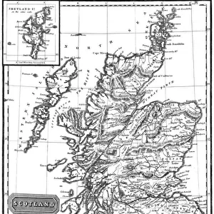
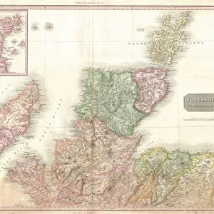
Metal Print : 1772, Bonne Map of Scotland, Rigobert Bonne 1727 - 1794, one of the most important


![]()
Metal Prints from Liszt Collection
1772, Bonne Map of Scotland, Rigobert Bonne 1727 - 1794, one of the most important
1772, Bonne Map of Scotland, Rigobert Bonne 1727 - 1794, one of the most important cartographers of the late 18th century
Liszt Collection of nineteenth-century engravings and images to browse and enjoy
Media ID 14006728
© Artokoloro Quint Lox Limited
1772 Rigobert Bonne 1727 1794 Rigobert Bonne 1727 – 1794 Rigobert Bonne 17271794 Antique Map Latitude Longitude Mappa Mundi Old Antique Plan Old Antique View Ols Antique Map Rare Old Maps Topo
16"x20" (51x41cm) Metal Print
Discover history through the lens of cartography with our Media Storehouse Metal Print of the 1772 Bonne Map of Scotland. This exquisite piece showcases the masterful work of Rigobert Bonne, a renowned cartographer of the late 18th century. With intricate detail and vivid colors, this metal print brings the historical map to life. The 1772 Bonne Map of Scotland is a prized addition to any home or office, perfect for history enthusiasts, cartography collectors, or those who appreciate the beauty of historical art. Experience the rich history of Scotland as you've never seen it before with this stunning metal print.
Made with durable metal and luxurious printing techniques, our metal photo prints go beyond traditional canvases, adding a cool, modern touch to your space. Wall mount on back. Eco-friendly 100% post-consumer recycled ChromaLuxe aluminum surface. The thickness of the print is 0.045". Featuring a Scratch-resistant surface and Rounded corners. Backing hangers are attached to the back of the print and float the print 1/2-inch off the wall when hung, the choice of hanger may vary depending on size and International orders will come with Float Mount hangers only. Finished with a brilliant white high gloss surface for unsurpassed detail and vibrance. Printed using Dye-Sublimation and for best care we recommend a non-ammonia glass cleaner, water, or isopropyl (rubbing) alcohol to prevent harming the print surface. We recommend using a clean, lint-free cloth to wipe off the print. The ultra-hard surface is scratch-resistant, waterproof and weatherproof. Avoid direct sunlight exposure.
Made with durable metal and luxurious printing techniques, metal prints bring images to life and add a modern touch to any space
Estimated Image Size (if not cropped) is 50.8cm x 40.6cm (20" x 16")
Estimated Product Size is 51.4cm x 41.2cm (20.2" x 16.2")
These are individually made so all sizes are approximate
Artwork printed orientated as per the preview above, with landscape (horizontal) orientation to match the source image.
FEATURES IN THESE COLLECTIONS
> Europe
> France
> Canton
> Landes
> Europe
> United Kingdom
> Scotland
> Maps
> Europe
> United Kingdom
> Scotland
> Posters
> Europe
> United Kingdom
> Scotland
> Related Images
> Historic
> Space exploration
> Maps and Charts
> Early Maps
> Maps and Charts
> Related Images
> Maps and Charts
> World
EDITORS COMMENTS
This vintage print showcases the remarkable 1772 Bonne Map of Scotland, created by the renowned cartographer Rigobert Bonne. Bonne, one of the most influential mapmakers of the late 18th century, meticulously crafted this masterpiece with an unwavering attention to detail. The map captures Scotland's topography and geography in exquisite fashion, providing a comprehensive illustration of its diverse landscapes and regions. Its precise depiction is a testament to Bonne's expertise in cartography and his dedication to accurately representing the world. Printed on aged paper, this historical artifact exudes an air of antiquity that transports us back to a time when exploration and discovery were at their peak. It serves as a captivating window into our past, offering glimpses into how people navigated through unknown territories centuries ago. With its decorative elements and intricate grid system indicating latitude and longitude lines, this antique map not only served practical purposes but also held artistic value. Its elegant design reflects both scientific precision and aesthetic beauty—a true mappa mundi capturing the essence of Scotland's rich history. Whether you are an avid traveler or simply fascinated by ancient maps, this rare find from the Liszt Collection is sure to ignite your curiosity about our world's past. Let it transport you on a journey through time as you explore Scotland through the eyes of Rigobert Bonne himself.
MADE IN THE USA
Safe Shipping with 30 Day Money Back Guarantee
FREE PERSONALISATION*
We are proud to offer a range of customisation features including Personalised Captions, Color Filters and Picture Zoom Tools
SECURE PAYMENTS
We happily accept a wide range of payment options so you can pay for the things you need in the way that is most convenient for you
* Options may vary by product and licensing agreement. Zoomed Pictures can be adjusted in the Cart.