Metal Print > Europe > United Kingdom > England > Tyne and Wear > Gateshead
Metal Print : Old Map of Newcastle upon Tyne 1851 by John Tallis


![]()
Metal Prints from MapSeeker
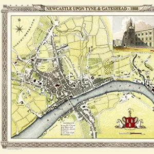
Old Map of Newcastle upon Tyne 1851 by John Tallis
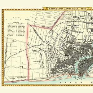
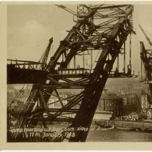
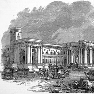
Newcastle 1851, Gateshead is to the bottom of the John Tallis 1851 plan of Newcastle in Tyne and Wear with the famous High Level Railway crossing the River Tyne into Newcastle Central station. There are four attractive illustrations finishing the plan. These illustrations are the Railway Bridge, Central Station, the Castle and a view of the High Level Bridge from Gateshead to Newcastle
Welcome to the Mapseeker Image library and enter an historic gateway to one of the largest on-line collections of Historic Maps, Nostalgic Views, Vista's and Panorama's from a World gone by.
Media ID 20347620
Historic Map John Tallis John Tallis Map Old Town Plan Tallis Map Gateshead Newcastle
16"x24" (61x41cm) Metal Print
Step back in time with our stunning Metal Print of the Old Map of Newcastle upon Tyne from 1851 by John Tallis. This intricately detailed map offers a captivating glimpse into the history of Newcastle and Gateshead, featuring the iconic High Level Railway crossing the River Tyne into Newcastle Central station. Our Metal Prints are known for their vibrant colors and exceptional clarity, ensuring that every line and detail of this historic map is brought to life. Add a touch of history and character to your home or office with this beautiful and unique piece of wall art.
Made with durable metal and luxurious printing techniques, our metal photo prints go beyond traditional canvases, adding a cool, modern touch to your space. Wall mount on back. Eco-friendly 100% post-consumer recycled ChromaLuxe aluminum surface. The thickness of the print is 0.045". Featuring a Scratch-resistant surface and Rounded corners. Backing hangers are attached to the back of the print and float the print 1/2-inch off the wall when hung, the choice of hanger may vary depending on size and International orders will come with Float Mount hangers only. Finished with a brilliant white high gloss surface for unsurpassed detail and vibrance. Printed using Dye-Sublimation and for best care we recommend a non-ammonia glass cleaner, water, or isopropyl (rubbing) alcohol to prevent harming the print surface. We recommend using a clean, lint-free cloth to wipe off the print. The ultra-hard surface is scratch-resistant, waterproof and weatherproof. Avoid direct sunlight exposure.
Made with durable metal and luxurious printing techniques, metal prints bring images to life and add a modern touch to any space
Estimated Product Size is 61.5cm x 41.2cm (24.2" x 16.2")
These are individually made so all sizes are approximate
Artwork printed orientated as per the preview above, with landscape (horizontal) orientation to match the source image.
FEATURES IN THESE COLLECTIONS
> MapSeeker
> British Town And City Plans
> English & Welsh PORTFOLIO
> Arts
> Artists
> T
> John Tallis
> Europe
> United Kingdom
> England
> Tyne and Wear
> Gateshead
> Europe
> United Kingdom
> England
> Tyne and Wear
> Newcastle upon Tyne
> Europe
> United Kingdom
> England
> Tyne and Wear
> Related Images
> Europe
> United Kingdom
> Northern Ireland
> County Down
> Newcastle
> Historic
> Medieval architecture
> Castles and fortresses
> Historic castles
> Maps and Charts
> Related Images
> Popular Themes
> Railway Posters
EDITORS COMMENTS
This print showcases an exquisite piece of history - the "Old Map of Newcastle upon Tyne 1851" by John Tallis. Transporting us back in time, this meticulously detailed map offers a glimpse into the bustling cityscape of Newcastle during the mid-19th century. The map encompasses both Newcastle and Gateshead, with Gateshead positioned at the bottom. One prominent feature is the iconic High Level Railway, elegantly crossing over the River Tyne and leading directly into Newcastle Central station. This railway served as a lifeline for transportation and trade, connecting these two vibrant towns. Accompanying this remarkable plan are four enchanting illustrations that add further charm to its composition. The first illustration captures the majestic Railway Bridge in all its grandeur, showcasing its architectural brilliance. The second depicts Central Station, a hub of activity where countless journeys began or ended. The third illustration portrays the historic Castle, standing tall as a symbol of strength and heritage within Newcastle's landscape. Lastly, we are treated to a captivating view from Gateshead towards Newcastle's High Level Bridge - an awe-inspiring sight that has stood as an engineering marvel for generations. This old town plan serves not only as a testament to John Tallis' artistry but also as a valuable historical artifact documenting how this beloved city once looked like centuries ago. It invites us to explore and appreciate the rich tapestry woven by our ancestors while offering glimpses into their daily lives and aspirations.
MADE IN THE USA
Safe Shipping with 30 Day Money Back Guarantee
FREE PERSONALISATION*
We are proud to offer a range of customisation features including Personalised Captions, Color Filters and Picture Zoom Tools
SECURE PAYMENTS
We happily accept a wide range of payment options so you can pay for the things you need in the way that is most convenient for you
* Options may vary by product and licensing agreement. Zoomed Pictures can be adjusted in the Cart.