Metal Print > Arts > Artists > T > John Tallis
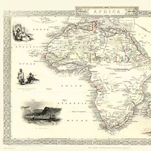
Metal Print : Old Map of Northern Africa 1851 by John Tallis


![]()
Metal Prints from MapSeeker
Old Map of Northern Africa 1851 by John Tallis
A fine facimile artworked from an antique original map of Northern Africa, issued as part of the 1851 edition of John Tallis and Companys " The Illustrated Atlas and Modern History of the World"
Welcome to the Mapseeker Image library and enter an historic gateway to one of the largest on-line collections of Historic Maps, Nostalgic Views, Vista's and Panorama's from a World gone by.
Media ID 20347477
© Mapseeker Publishing Ltd
John Tallis John Tallis Map Tallis Tallis Map Northern Africa
16"x24" (61x41cm) Metal Print
Step back in time with our exquisite Metal Prints featuring the Old Map of Northern Africa 1851 by John Tallis and John Rapkin from MapSeeker. This fine facsimile artwork is meticulously reproduced from an original antique map published in the 1851 edition of John Tallis and Company's "The Illustrated Atlas". The intricate details and vibrant colors of the map are beautifully preserved in this premium Metal Print, adding a touch of history and sophistication to any space. Each print is carefully crafted using high-quality materials and state-of-the-art printing techniques to ensure a stunning, long-lasting display. Travel back in time and explore the historical wonders of Northern Africa with this captivating piece of art.
Made with durable metal and luxurious printing techniques, our metal photo prints go beyond traditional canvases, adding a cool, modern touch to your space. Wall mount on back. Eco-friendly 100% post-consumer recycled ChromaLuxe aluminum surface. The thickness of the print is 0.045". Featuring a Scratch-resistant surface and Rounded corners. Backing hangers are attached to the back of the print and float the print 1/2-inch off the wall when hung, the choice of hanger may vary depending on size and International orders will come with Float Mount hangers only. Finished with a brilliant white high gloss surface for unsurpassed detail and vibrance. Printed using Dye-Sublimation and for best care we recommend a non-ammonia glass cleaner, water, or isopropyl (rubbing) alcohol to prevent harming the print surface. We recommend using a clean, lint-free cloth to wipe off the print. The ultra-hard surface is scratch-resistant, waterproof and weatherproof. Avoid direct sunlight exposure.
Made with durable metal and luxurious printing techniques, metal prints bring images to life and add a modern touch to any space
Estimated Product Size is 61.5cm x 41.2cm (24.2" x 16.2")
These are individually made so all sizes are approximate
Artwork printed orientated as per the preview above, with landscape (horizontal) orientation to match the source image.
FEATURES IN THESE COLLECTIONS
> MapSeeker
> Maps of Africa and Oceana
> Old Maps Showing the Continent of
> Arts
> Artists
> T
> John Tallis
> Maps and Charts
> World
Old Map of Northern Africa 1851 - A Glimpse into the Rich History of a Continent
EDITORS COMMENTS
. This print showcases an exquisite facsimile artwork, meticulously reproduced from an antique original map of Northern Africa dating back to 1851. As part of John Tallis and Company's renowned "The Illustrated Atlas and Modern History of the World" this map offers a fascinating glimpse into the past. With intricate details and stunning craftsmanship, this old map takes us on a journey through time, revealing the diverse landscapes and historical significance of Northern Africa. From the vast Sahara Desert to the fertile Nile Valley, every contour is delicately depicted, capturing both geographical accuracy and artistic beauty. John Tallis' expertise in cartography shines through as he presents a comprehensive overview of this region's cities, towns, rivers, mountains, and trade routes. The attention to detail extends beyond geography; it also includes cultural symbols representing ancient civilizations that once thrived in these lands. As we explore this vintage masterpiece by John Tallis and his collaborator John Rapkin, we are transported back to an era when exploration was at its peak. This old African map serves as a reminder of our shared human history while igniting curiosity about how societies have evolved over time. Whether you are an avid historian or simply captivated by artistry from yesteryears, this print is sure to be cherished for its historical significance and aesthetic appeal. It invites us to reflect upon Northern Africa's rich heritage while appreciating
MADE IN THE USA
Safe Shipping with 30 Day Money Back Guarantee
FREE PERSONALISATION*
We are proud to offer a range of customisation features including Personalised Captions, Color Filters and Picture Zoom Tools
SECURE PAYMENTS
We happily accept a wide range of payment options so you can pay for the things you need in the way that is most convenient for you
* Options may vary by product and licensing agreement. Zoomed Pictures can be adjusted in the Cart.