Metal Print > Arts > Artists > T > John Tallis
Metal Print : Old Map of Boston United States of America 1851 by John Tallis


![]()
Metal Prints from MapSeeker
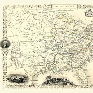
Old Map of Boston United States of America 1851 by John Tallis
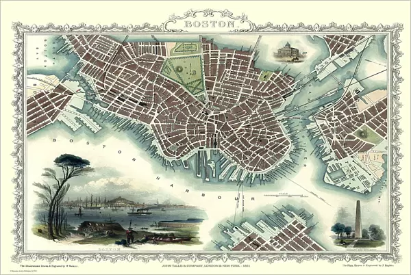
This a most attractive plan of Boston by John Tallis 1851 that includes South Boston Bay, part of South Boston with Charleston Town to the right of the plan. There is a stunning view across Boston Harbour with locals in the foreground. The other illustration is of Bunkers Hill Monument
Welcome to the Mapseeker Image library and enter an historic gateway to one of the largest on-line collections of Historic Maps, Nostalgic Views, Vista's and Panorama's from a World gone by.
Media ID 20347882
Historic Map John Tallis John Tallis Map Old Town Plan Tallis Map Boston City
16"x24" (61x41cm) Metal Print
Discover history with our stunning Metal Prints from Media Storehouse. This particular piece features an Old Map of Boston, USA from 1851 by John Tallis, as seen in MapSeeker. The intricate details of South Boston Bay and the surrounding areas, including South Boston and Charleston Town, come alive in vibrant colors on high-quality metal. Each print is meticulously crafted to bring out the rich textures and depth of the original map. Hang it up in your home or office as a conversation starter and a beautiful addition to your decor. Order now and step back in time with Media Storehouse's Metal Prints.
Made with durable metal and luxurious printing techniques, our metal photo prints go beyond traditional canvases, adding a cool, modern touch to your space. Wall mount on back. Eco-friendly 100% post-consumer recycled ChromaLuxe aluminum surface. The thickness of the print is 0.045". Featuring a Scratch-resistant surface and Rounded corners. Backing hangers are attached to the back of the print and float the print 1/2-inch off the wall when hung, the choice of hanger may vary depending on size and International orders will come with Float Mount hangers only. Finished with a brilliant white high gloss surface for unsurpassed detail and vibrance. Printed using Dye-Sublimation and for best care we recommend a non-ammonia glass cleaner, water, or isopropyl (rubbing) alcohol to prevent harming the print surface. We recommend using a clean, lint-free cloth to wipe off the print. The ultra-hard surface is scratch-resistant, waterproof and weatherproof. Avoid direct sunlight exposure.
Made with durable metal and luxurious printing techniques, metal prints bring images to life and add a modern touch to any space
Estimated Product Size is 61.5cm x 41.2cm (24.2" x 16.2")
These are individually made so all sizes are approximate
Artwork printed orientated as per the preview above, with landscape (horizontal) orientation to match the source image.
FEATURES IN THESE COLLECTIONS
> MapSeeker
> Maps of the Americas
> Maps of the United States of America
> Arts
> Artists
> H
> John Hillers
> Arts
> Artists
> H
> John Hills
> Arts
> Artists
> T
> John Tallis
> Historic
> Monuments and landmarks
> Monuments and memorials
> Maps and Charts
> Related Images
> North America
> United States of America
> Maps
> South America
> Related Images
EDITORS COMMENTS
This print showcases an exquisite piece of history - the "Old Map of Boston United States of America 1851" by John Tallis. A true gem for map enthusiasts and history buffs alike, this plan offers a fascinating glimpse into the past. The intricate details on this map are truly remarkable. From South Boston Bay to Charleston Town, every street and landmark is meticulously depicted, providing a comprehensive view of the city in 1851. The inclusion of locals in the foreground adds life and authenticity to the scene, allowing us to imagine what it was like during that era. One cannot help but be drawn to the stunning view across Boston Harbor captured in this print. It transports us back in time, evoking a sense of wonder as we envision ships sailing through these waters centuries ago. Additionally, another highlight featured on this map is Bunker Hill Monument. This iconic structure stands tall as a testament to one of America's most significant historical events - the Battle of Bunker Hill during the Revolutionary War. Whether you're interested in exploring Boston's rich heritage or simply appreciate beautifully crafted maps, this old town plan by John Tallis is sure to captivate your imagination. Its historic significance combined with its aesthetic appeal make it a must-have for any collector or enthusiast seeking a tangible connection to our past.
MADE IN THE USA
Safe Shipping with 30 Day Money Back Guarantee
FREE PERSONALISATION*
We are proud to offer a range of customisation features including Personalised Captions, Color Filters and Picture Zoom Tools
SECURE PAYMENTS
We happily accept a wide range of payment options so you can pay for the things you need in the way that is most convenient for you
* Options may vary by product and licensing agreement. Zoomed Pictures can be adjusted in the Cart.