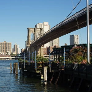
Metal Print > Architecture > Bridges > Brooklyn Bridge
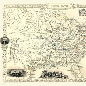
Metal Print : Old Map of New York United States of America 1851 by John Tallis

![]()
Metal Prints from MapSeeker
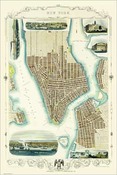
Old Map of New York United States of America 1851 by John Tallis
This is a most attractive yet detailed plan 1851 by John Tallis of New York and districts of Jersey, Panovia, Hoboken, Brooklyn and Williamsburgh in the U.S.A. The numerous, identified ferries are flourishing with increasing traffic across the Hudson and East River, the great bridges have not yet arrived. Many individual docking ports and Packets are named. The plan of New York has been beautifully finished with six illustrations. To the top of the plan a view towards Brooklyn with sailing boats and steamers. To the top right City Hall and the Custom House. At the bottom a panoramic view across to New York from Williamsburg and a view of the Narrows from Fort Hamilton. There is New York Steamer to the top left
Welcome to the Mapseeker Image library and enter an historic gateway to one of the largest on-line collections of Historic Maps, Nostalgic Views, Vista's and Panorama's from a World gone by.
Media ID 20347586
Historic Map John Tallis John Tallis Map Old Town Plan Tallis Map
16"x24" (61x41cm) Metal Print
Step back in time with our captivating Metal Print of the Old Map of New York from John Tallis, dated 1851. This intricately detailed map showcases New York and its surrounding districts, including Jersey, Hoboken, Brooklyn, and Williamsburg. Each contour and line is meticulously preserved in this high-quality Metal Print, creating a stunning visual representation of New York's rich history. Display this vintage map as a conversation starter in your home or office, and let the stories of the past come alive.
Made with durable metal and luxurious printing techniques, our metal photo prints go beyond traditional canvases, adding a cool, modern touch to your space. Wall mount on back. Eco-friendly 100% post-consumer recycled ChromaLuxe aluminum surface. The thickness of the print is 0.045". Featuring a Scratch-resistant surface and Rounded corners. Backing hangers are attached to the back of the print and float the print 1/2-inch off the wall when hung, the choice of hanger may vary depending on size and International orders will come with Float Mount hangers only. Finished with a brilliant white high gloss surface for unsurpassed detail and vibrance. Printed using Dye-Sublimation and for best care we recommend a non-ammonia glass cleaner, water, or isopropyl (rubbing) alcohol to prevent harming the print surface. We recommend using a clean, lint-free cloth to wipe off the print. The ultra-hard surface is scratch-resistant, waterproof and weatherproof. Avoid direct sunlight exposure.
Made with durable metal and luxurious printing techniques, metal prints bring images to life and add a modern touch to any space
Estimated Product Size is 41.2cm x 61.5cm (16.2" x 24.2")
These are individually made so all sizes are approximate
Artwork printed orientated as per the preview above, with portrait (vertical) orientation to match the source image.
FEATURES IN THESE COLLECTIONS
> MapSeeker
> Maps of the Americas
> Maps of the United States of America
> Architecture
> Bridges
> Brooklyn Bridge
> Arts
> Artists
> T
> John Tallis
> Arts
> Photorealistic artworks
> Detailed art pieces
> Masterful detailing in art
> Europe
> United Kingdom
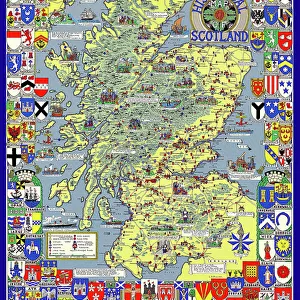
> Scotland
> Strathclyde
> Hamilton
> Maps and Charts
> Related Images
> North America
> United States of America
> New Jersey
> Jersey City
> North America
> United States of America
> New York
> New York
> Bridges
> Brooklyn Bridge
> North America
> United States of America
> New York
> New York
> Bridges
> Related Images
EDITORS COMMENTS
This print showcases an exquisite and meticulously detailed plan of New York City in 1851, crafted by the talented cartographer John Tallis. The map encompasses not only New York but also neighboring districts such as Jersey, Panovia, Hoboken, Brooklyn, and Williamsburgh within the United States of America. As one explores this enchanting piece of history, they will notice the bustling ferries traversing the Hudson and East River, long before the advent of grand bridges that now grace these waters. Every individual docking port and Packet is thoughtfully labeled on this map, providing a glimpse into the thriving maritime activity of that era. Additionally, six beautifully illustrated vignettes adorn this masterpiece: sailing boats and steamers dotting the view towards Brooklyn at its top; City Hall and Custom House majestically positioned to its top right; a panoramic vista across to New York from Williamsburg gracing its bottom section; and finally, a mesmerizing depiction of Fort Hamilton offering a view of the Narrows. Immerse yourself in this historic treasure which offers an insight into how New York City appeared over 150 years ago. With its remarkable attention to detail and artistic flair evident throughout every inch of this work by John Tallis – renowned for his exceptional craftsmanship – it serves as both a testament to our rich past while igniting curiosity about how much has changed since then.
MADE IN THE USA
Safe Shipping with 30 Day Money Back Guarantee
FREE PERSONALISATION*
We are proud to offer a range of customisation features including Personalised Captions, Color Filters and Picture Zoom Tools
SECURE PAYMENTS
We happily accept a wide range of payment options so you can pay for the things you need in the way that is most convenient for you
* Options may vary by product and licensing agreement. Zoomed Pictures can be adjusted in the Cart.