Metal Print > Arts > Photorealistic artworks > Detailed art pieces > Masterful detailing in art
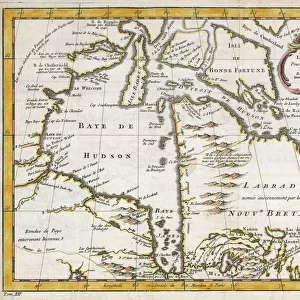
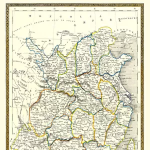
Metal Print : Old Map of Northern India 1852 by Henry George Collins


![]()
Metal Prints from MapSeeker
Old Map of Northern India 1852 by Henry George Collins
This is a finely detailed map of Northern India remastered from a rare Atlas of the World published in 1852 by Henry George Collins. Although these Henry Collins produced maps of the highest quality in his time unfortunately not the same could be said in terms of his business success. His maps were later obtained by the famous Stanford Map Company and used in their publications
Welcome to the Mapseeker Image library and enter an historic gateway to one of the largest on-line collections of Historic Maps, Nostalgic Views, Vista's and Panorama's from a World gone by.
Media ID 20347269
© Mapseeker Publishing Ltd
Collins Collins Atlas Collins Atlas Map Collins Map North India Northern India
16"x24" (61x41cm) Metal Print
Discover history with our exquisite Metal Prints featuring the Old Map of Northern India from 1852 by Henry George Collins. This finely detailed map, remastered from the rare Atlas of the World published by Henry George Collins, showcases the rich cultural and historical landscape of Northern India during that era. Our high-quality Metal Prints bring the intricate lines and vibrant colors of this antique map to life, making it a stunning addition to any home or office decor. Relive history with this unique and captivating piece.
Made with durable metal and luxurious printing techniques, our metal photo prints go beyond traditional canvases, adding a cool, modern touch to your space. Wall mount on back. Eco-friendly 100% post-consumer recycled ChromaLuxe aluminum surface. The thickness of the print is 0.045". Featuring a Scratch-resistant surface and Rounded corners. Backing hangers are attached to the back of the print and float the print 1/2-inch off the wall when hung, the choice of hanger may vary depending on size and International orders will come with Float Mount hangers only. Finished with a brilliant white high gloss surface for unsurpassed detail and vibrance. Printed using Dye-Sublimation and for best care we recommend a non-ammonia glass cleaner, water, or isopropyl (rubbing) alcohol to prevent harming the print surface. We recommend using a clean, lint-free cloth to wipe off the print. The ultra-hard surface is scratch-resistant, waterproof and weatherproof. Avoid direct sunlight exposure.
Made with durable metal and luxurious printing techniques, metal prints bring images to life and add a modern touch to any space
Estimated Product Size is 61.5cm x 41.2cm (24.2" x 16.2")
These are individually made so all sizes are approximate
Artwork printed orientated as per the preview above, with landscape (horizontal) orientation to match the source image.
FEATURES IN THESE COLLECTIONS
> MapSeeker
> Maps of Asia and Middle East
> Maps of Countries in Asia PORTFOLIO
> Arts
> Photorealistic artworks
> Detailed art pieces
> Masterful detailing in art
> Asia
> India
> Related Images
> Maps and Charts
> India
> Maps and Charts
> Related Images
> Maps and Charts
> World
EDITORS COMMENTS
This beautifully preserved print showcases an Old Map of Northern India from 1852, meticulously crafted by the talented cartographer Henry George Collins. Remastered from a rare Atlas of the World published in that era, this map offers a fascinating glimpse into the geographical landscape and political boundaries of Northern India during that time. Henry Collins was renowned for his exceptional craftsmanship and attention to detail when it came to creating maps. His dedication to accuracy is evident in this piece, as every intricate feature is carefully depicted. From rivers and mountain ranges to cities and villages, this map provides an invaluable historical record of Northern India's geography. Despite his undeniable talent, Henry Collins did not achieve great success in terms of business ventures. However, fate smiled upon him when his remarkable maps caught the attention of the esteemed Stanford Map Company. Recognizing their value and quality, they acquired Collins' collection and incorporated them into their own publications. Nowadays, this remastered print serves as a testament to both Henry George Collins' skill as a cartographer and the enduring legacy of his work. It allows us to travel back in time and explore Northern India through the eyes of those who lived there over 150 years ago. A true treasure for history enthusiasts or anyone with an appreciation for fine craftsmanship.
MADE IN THE USA
Safe Shipping with 30 Day Money Back Guarantee
FREE PERSONALISATION*
We are proud to offer a range of customisation features including Personalised Captions, Color Filters and Picture Zoom Tools
SECURE PAYMENTS
We happily accept a wide range of payment options so you can pay for the things you need in the way that is most convenient for you
* Options may vary by product and licensing agreement. Zoomed Pictures can be adjusted in the Cart.