Metal Print > Europe > United Kingdom > England > County Durham > Durham
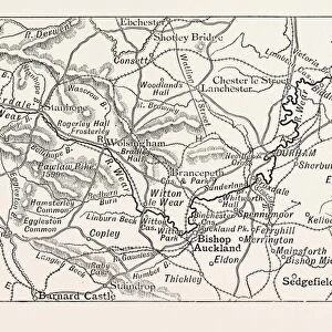
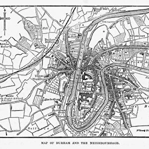
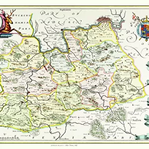
Metal Print : Old County Map of Durham 1648 by Johan Blaeu from the Atlas Novus


![]()
Metal Prints from MapSeeker
Old County Map of Durham 1648 by Johan Blaeu from the Atlas Novus
This detailed and most attractive reproduction map of Durham has been carefully art worked from a scan of an antique original. The famous firm of Dutch cartographers and publishers was established in the late 16th century by Willem Janszoon Blaeu in Amsterdam. Blaeu was a maker of globes and scientific instruments and purchased some of his early map plates from Jodocus Hondius. From this small beginning was to emerge one of the largest and most prolific map publishing houses of the seventeenth century
Welcome to the Mapseeker Image library and enter an historic gateway to one of the largest on-line collections of Historic Maps, Nostalgic Views, Vista's and Panorama's from a World gone by.
Media ID 20347856
Blaeu Blaeu Family Blaue Map County Map County Map Of England English County Map Historic Map Johan Blaeu Johan Blaeu Map Old Blaue Map Old County Map Old English County Map Durham
16"x24" (61x41cm) Metal Print
Discover the rich history of Durham with our exquisite Metal Print of the Old County Map of Durham 1648 by Johan Blaeu from the Atlas Novus, available at Media Storehouse. This meticulously crafted reproduction brings the intricate details of the antique original to life, transporting you back in time. The Old County Map of Durham, created by renowned cartographer Johan Blaeu, offers a captivating glimpse into the geography and architecture of the region during the 17th century. Each Metal Print is carefully art-worked from a high-resolution scan of the original map, ensuring the finest details are preserved. Elevate your home or office décor with this unique and captivating piece of historical art.
Made with durable metal and luxurious printing techniques, our metal photo prints go beyond traditional canvases, adding a cool, modern touch to your space. Wall mount on back. Eco-friendly 100% post-consumer recycled ChromaLuxe aluminum surface. The thickness of the print is 0.045". Featuring a Scratch-resistant surface and Rounded corners. Backing hangers are attached to the back of the print and float the print 1/2-inch off the wall when hung, the choice of hanger may vary depending on size and International orders will come with Float Mount hangers only. Finished with a brilliant white high gloss surface for unsurpassed detail and vibrance. Printed using Dye-Sublimation and for best care we recommend a non-ammonia glass cleaner, water, or isopropyl (rubbing) alcohol to prevent harming the print surface. We recommend using a clean, lint-free cloth to wipe off the print. The ultra-hard surface is scratch-resistant, waterproof and weatherproof. Avoid direct sunlight exposure.
Made with durable metal and luxurious printing techniques, metal prints bring images to life and add a modern touch to any space
Estimated Product Size is 61.5cm x 41.2cm (24.2" x 16.2")
These are individually made so all sizes are approximate
Artwork printed orientated as per the preview above, with landscape (horizontal) orientation to match the source image.
FEATURES IN THESE COLLECTIONS
> MapSeeker
> Maps from the British Isles
> England and Counties PORTFOLIO
> Arts
> Artists
> B
> Willem Blaeu
> Arts
> Artists
> H
> Jodocus Hondius
> Arts
> Photorealistic artworks
> Detailed art pieces
> Masterful detailing in art
> Europe
> United Kingdom
> England
> County Durham
> Durham
> Europe
> United Kingdom
> England
> Durham
> Durham
> Europe
> United Kingdom
> England
> Maps
> Maps and Charts
> Early Maps
> Maps and Charts
> Willem Janszoon Blaeu
EDITORS COMMENTS
This beautifully crafted reproduction of the "Old County Map of Durham 1648" by Johan Blaeu takes us back in time to explore the historical landscape of this English county. Carefully art worked from an antique original, this detailed map showcases the expertise and craftsmanship that made the Dutch cartographers and publishers, Blaeu family, renowned during the seventeenth century. Established by Willem Janszoon Blaeu in Amsterdam, their reputation grew rapidly as they became one of the largest and most prolific map publishing houses of their time. This particular map was created using plates acquired from Jodocus Hondius, further enhancing its authenticity and historical significance. As we delve into this old English county map, we are transported to a bygone era when Durham's boundaries were defined differently than today. The intricate details on this historic piece allow us to trace ancient roads, rivers, towns, and landmarks that have shaped Durham's rich heritage. Whether you're a history enthusiast or simply captivated by cartography's beauty, this print is sure to be a cherished addition to any collection. Its timeless appeal offers a glimpse into centuries past while celebrating Johan Blaeu's remarkable contribution to mapping our world
MADE IN THE USA
Safe Shipping with 30 Day Money Back Guarantee
FREE PERSONALISATION*
We are proud to offer a range of customisation features including Personalised Captions, Color Filters and Picture Zoom Tools
SECURE PAYMENTS
We happily accept a wide range of payment options so you can pay for the things you need in the way that is most convenient for you
* Options may vary by product and licensing agreement. Zoomed Pictures can be adjusted in the Cart.