Metal Print > Arts > Artists > S > John Speed
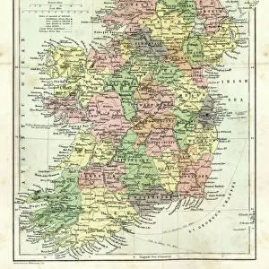
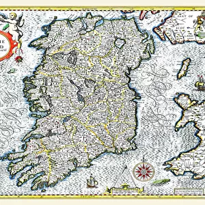
Metal Print : Old Map of Ireland 1611 by John Speed


Metal Prints from MapSeeker
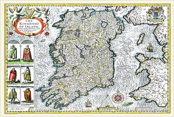
Old Map of Ireland 1611 by John Speed
A facimile of John Speeds historical map of Ireland originally published for the " Theatre of the Empire of Great Britain", an atlas to accompany " a history of Great Britain"
Welcome to the Mapseeker Image library and enter an historic gateway to one of the largest on-line collections of Historic Maps, Nostalgic Views, Vista's and Panorama's from a World gone by.
Media ID 20347933
© Mapseeker Publishing Ltd
Historic Map John Speed Map Speed Map John Speed
16"x24" (61x41cm) Metal Print
Step back in time with our exquisite Metal Print of the Old Map of Ireland 1611 by John Speed from MapSeeker. This meticulously crafted reproduction is a facsimile of the historical map originally published in the "Theatre of the Empire of Great Britain," an atlas accompanying "A History of Great Britain." The intricate details of this vintage map are brought to life on a durable metal print, adding an element of sophistication and history to any space. Explore the rich heritage of Ireland with this stunning piece of decor, perfect for history enthusiasts, collectors, or those who appreciate the beauty of antique cartography.
Made with durable metal and luxurious printing techniques, our metal photo prints go beyond traditional canvases, adding a cool, modern touch to your space. Wall mount on back. Eco-friendly 100% post-consumer recycled ChromaLuxe aluminum surface. The thickness of the print is 0.045". Featuring a Scratch-resistant surface and Rounded corners. Backing hangers are attached to the back of the print and float the print 1/2-inch off the wall when hung, the choice of hanger may vary depending on size and International orders will come with Float Mount hangers only. Finished with a brilliant white high gloss surface for unsurpassed detail and vibrance. Printed using Dye-Sublimation and for best care we recommend a non-ammonia glass cleaner, water, or isopropyl (rubbing) alcohol to prevent harming the print surface. We recommend using a clean, lint-free cloth to wipe off the print. The ultra-hard surface is scratch-resistant, waterproof and weatherproof. Avoid direct sunlight exposure.
Made with durable metal and luxurious printing techniques, metal prints bring images to life and add a modern touch to any space
Estimated Product Size is 61.5cm x 41.2cm (24.2" x 16.2")
These are individually made so all sizes are approximate
Artwork printed orientated as per the preview above, with landscape (horizontal) orientation to match the source image.
FEATURES IN THESE COLLECTIONS
> MapSeeker
> Maps from the British Isles
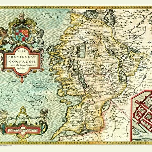
> Ireland and Provinces PORTFOLIO
> Arts
> Artists
> S
> John Speed
> Europe
> Republic of Ireland
> Maps
> Maps and Charts
> British Empire Maps
> Maps and Charts
> Early Maps
> Maps and Charts
> Related Images
EDITORS COMMENTS
This print showcases the remarkable "Old Map of Ireland 1611" by John Speed, a renowned cartographer from the early 17th century. Originally published for his monumental work, "Theatre of the Empire of Great Britain" this map is an exquisite representation of Ireland's historical geography. With intricate details and artistic flair, Speed meticulously crafted this facsimile to accompany his comprehensive history of Great Britain. The map offers a fascinating glimpse into Ireland's past, capturing its diverse landscapes, ancient settlements, and significant landmarks. As you explore this old Irish map, you'll be transported back in time to an era when cartography was both science and art. Every contour line and symbol tells a story about Ireland's rich heritage and cultural tapestry. From the rugged coastlines to lush green valleys, each region is delicately illustrated with precision and care. This historic treasure allows us to trace the footsteps of our ancestors while unraveling centuries-old mysteries that shaped the Emerald Isle. Whether you're an avid historian or simply captivated by maps' beauty, this John Speed masterpiece will undoubtedly ignite your curiosity about Ireland's past. Display it proudly on your wall or use it as a conversation starter among friends – either way; it serves as a testament to Speed's extraordinary talent in documenting history through cartography.
MADE IN THE USA
Safe Shipping with 30 Day Money Back Guarantee
FREE PERSONALISATION*
We are proud to offer a range of customisation features including Personalised Captions, Color Filters and Picture Zoom Tools
SECURE PAYMENTS
We happily accept a wide range of payment options so you can pay for the things you need in the way that is most convenient for you
* Options may vary by product and licensing agreement. Zoomed Pictures can be adjusted in the Cart.